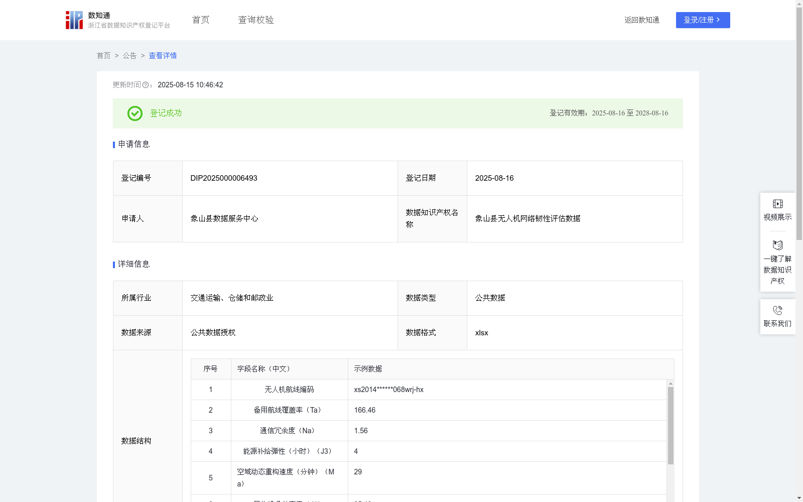
象山县无人机网络韧性评估数据
收藏浙江省数据知识产权登记平台2025-08-15 更新2025-08-16 收录
下载链接:
https://www.zjip.org.cn/home/announce/trends/164931
下载链接
链接失效反馈官方服务:
资源简介:
该数据可显著提升城市低空网络的抗风险能力与持续服务保障水平。通过实时监测通信、能源、空域等多维系统状态,能够提前预警潜在运行风险,并在突发气象变化、设备故障或空域管制等异常情况下,快速生成最优应对方案。模型帮助管理者优化备用资源布局,加强不同厂商设备的协同兼容性,确保在极端条件下仍能维持基础物流服务。同时促进地面交通与低空系统的联动响应,构建起立体化应急保障体系,为城市低空经济的安全稳定发展提供智能化决策支撑。根据无人机调度系统的中主航线中断时可替代路径占比获得备用航线覆盖率(%)Ta;根据基站故障时备用通信链路强度(5G专网强度)获得通信冗余度Na;根据全网络断电后持续运行能力获得能源补给弹性(小时)J3;根据突发管制后新航线生成耗时获得空域动态重构速度(分钟)Ma;根据不同厂商设备协同运行能力获得异构设备兼容率(%)J1;根据实时天气数据获得气象突变响应指数(分)S;根据无人机调度系统中的远程操作修复时的设备自动恢复功能成功率(%)获得故障自愈率(%)J2;根据交通应急物资管理平台的无人机电池储备数据获得应急物资储备指数Ht;所有采集汇总数据通过多因子归一化处理,最终通过线性加权法进行计算:Y=(Ta/100x25+Nax20+J3x15)x(Ma^-0.1+J1/100x10)+(Sx12+J2/100x10)xHt,最终获得象山县无人机网络韧性评估指数,I级,紧急响应(0-2000),立即强制措施:暂停受干扰区域全部航班,启动备用地面网络、基础设施修复:优先恢复通信基站与充电桩运作,通过移动电源车建立临时能源补给节点
、航线重组:基于无人机调度系统生成临时绕飞方案,重构速度需控制在10分钟以内;II级,警戒状态(2001-5000)动态航路调整:按30分钟间隔刷新备选航线覆盖率,确保不低于设计容量的120%、
资源动态调配:将应急物资储备指数提升至1.5以上,部署移动式信号增强设备、协同监控强化:启动陆空联合执勤机制,无人机违规修正响应时延压缩至120秒内;III级,稳健运行(5001-8000)算法持续优化:运用强化学习提升气象突变响应速度,预案完备度目标值提升至90分、异构兼容升级:强制要求新增设备通过多厂商协同认证测试,兼容率保持95%以上、预防性维护:建立电池健康度预测模型,提前48小时预警充电桩故障风险;IV级,卓越韧性(8001+)韧性基建升级、智能进化机制、生态协同建设。
This dataset can significantly enhance the risk resilience and continuous service support capabilities of urban low-altitude networks. By conducting real-time monitoring of multi-dimensional system states including communications, energy, and airspace, it can issue early warnings of potential operational risks and rapidly generate optimal response plans under abnormal scenarios such as sudden meteorological changes, equipment failures, or airspace control. The model aids managers in optimizing the layout of backup resources, enhancing the collaborative compatibility of equipment from different manufacturers, and ensuring that basic logistics services remain operational under extreme conditions. Meanwhile, it promotes the coordinated response between ground transportation and low-altitude systems, builds a three-dimensional emergency support system, and provides intelligent decision-making support for the safe and stable development of the urban low-altitude economy. Obtain the backup route coverage rate (%, denoted as Ta) based on the proportion of alternative paths when the main route in the UAV scheduling system is interrupted; Obtain the communication redundancy Na based on the strength of backup communication links (5G private network strength) when base stations fail; Obtain the energy supply resilience (in hours, denoted as J3) based on the continuous operation capability after the entire network is powered off; Obtain the airspace dynamic reconfiguration speed (in minutes, denoted as Ma) based on the time required to generate new routes after sudden airspace control; Obtain the heterogeneous device compatibility rate (%, denoted as J1) based on the collaborative operation capability of equipment from different manufacturers; Obtain the meteorological sudden change response index (in points, denoted as S) based on real-time weather data; Obtain the fault self-healing rate (%, denoted as J2) based on the success rate of the automatic device recovery function during remote operation and repair in the UAV scheduling system; Obtain the emergency material reserve index Ht based on the UAV battery reserve data from the traffic emergency material management platform. All collected and aggregated data undergo multi-factor normalization processing, and are finally calculated using the linear weighting method: Y=(Ta/100×25 + Na×20 + J3×15)×(Ma^-0.1 + J1/100×10) + (S×12 + J2/100×10)×Ht. The UAV network resilience assessment index for Xiangshan County is finally obtained. Level I, Emergency Response (0-2000): Immediate enforcement measures include suspending all flights in the affected area, activating backup ground networks, and infrastructure restoration: prioritize restoring the operation of communication base stations and charging piles, and establish temporary energy supply nodes via mobile power vehicles; route restructuring: generate temporary detour plans based on the UAV scheduling system, with the reconfiguration speed required to be controlled within 10 minutes. Level II, Alert Status (2001-5000): Dynamic route adjustment: refresh the alternative route coverage rate every 30 minutes to ensure it is no less than 120% of the designed capacity; resource dynamic allocation: raise the emergency material reserve index to above 1.5, deploy mobile signal enhancement equipment; collaborative monitoring enhancement: activate the land-air joint duty mechanism, and compress the response delay for correcting UAV violations to within 120 seconds. Level III, Stable Operation (5001-8000): Continuous algorithm optimization: use reinforcement learning to improve the response speed to sudden meteorological changes, and increase the target value of plan completeness to 90 points; heterogeneous compatibility upgrade: mandate that newly added equipment pass multi-manufacturer collaborative certification tests, and maintain a compatibility rate of over 95%; preventive maintenance: establish a battery health prediction model to early warn of charging pile failure risks 48 hours in advance. Level IV, Excellent Resilience (8001+): Resilient infrastructure upgrading, intelligent evolution mechanism, and ecological collaborative construction.
提供机构:
象山县数据服务中心
创建时间:
2025-05-29
搜集汇总
数据集介绍
背景与挑战
背景概述
该数据集为象山县无人机网络韧性评估数据,包含1001条记录,每季度更新一次,主要用于评估无人机网络的抗风险能力和持续服务保障水平。数据集通过多维度指标(如备用航线覆盖率、通信冗余度、能源补给弹性等)和算法规则,为城市低空经济的安全稳定发展提供智能化决策支撑。
以上内容由遇见数据集搜集并总结生成


