青藏高原边界数据总集
收藏地球大数据科学工程2024-03-04 收录
下载链接:
https://data.casearth.cn/sdo/detail/5feae826819aec33049b7ca9
下载链接
链接失效反馈官方服务:
资源简介:
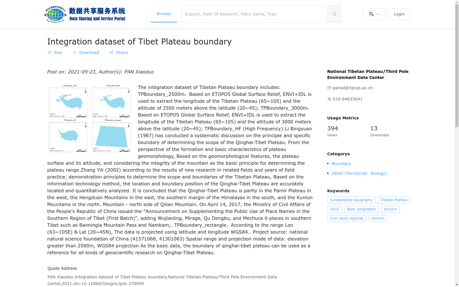
此边界数据总集包含四种类型的边界:
TPBoundary_2500:基于ETOPO5 Global Surface Relief,采用ENVI+IDL 提取青藏高原经度(65~105E),纬度(20~45N)范围内海拔高程2500米的数据;
TPBoundary_3000:基于ETOPO5 Global Surface Relief,采用ENVI+IDL 提取青藏高原经度(65~105E),纬度(20~45N)范围内海拔高程3000米的数据;
TPBoundary_HF(high_frequency):李炳元(1987)曾对确定青藏高原范围的原则与具体界线进行了较系统的讨论,从高原地貌形成和基本特征角度,提出了依据地貌特征、高原面及其海拔高度,同时考虑山体完整性作为确定高原范围的基本原则。张镱锂(2002) 根据相关领域研究的新成果和多年野外实践,论证确定青藏高原范围和界线的原则, 结合信息技术方法对青藏高原范围与界线位置进行了精确的定位和定量分析,得出:青藏高 原在中国境内部分西起帕米尔高原,东至横断山脉,南自喜马拉雅山脉南缘,北迄昆仑山— 祁连山北侧。
2017年4月14日,中华人民共和国民政部发布《关于增补藏南地区公开使用地名(第一批)的公告》,增加了乌间岭、米拉日、曲登嘎布日、梅楚卡、白明拉山口、纳姆卡姆等6个藏南地区地名;
TPBoundary_rectangle:根据范围Lon(63~105E) Lat(20~45N),画取长方形,数据采用经纬度投影WGS84。
青藏高原边界作为基础数据,可以为各类地学数据及科学研究青藏高原作参考依据。
This comprehensive boundary dataset includes four types of boundaries:
TPBoundary_2500: Derived from ETOPO5 Global Surface Relief, this dataset was extracted using ENVI+IDL, targeting the area within 65°E–105°E longitude and 20°N–45°N latitude of the Tibetan Plateau with an elevation of 2500 meters;
TPBoundary_3000: Derived from ETOPO5 Global Surface Relief, this dataset was extracted using ENVI+IDL, targeting the area within 65°E–105°E longitude and 20°N–45°N latitude of the Tibetan Plateau with an elevation of 3000 meters;
TPBoundary_HF (high_frequency): In 1987, Li Bingyuan systematically discussed the principles and specific boundaries for defining the Tibetan Plateau. From the perspective of plateau geomorphology formation and basic characteristics, he proposed the core principles for determining the plateau's scope: geomorphic features, plateau surface and its elevation, as well as the integrity of mountain bodies. In 2002, Zhang Yili demonstrated and determined the principles for defining the Tibetan Plateau's scope and boundaries based on new research achievements in relevant fields and years of fieldwork. Combining with information technology methods, he conducted precise positioning and quantitative analysis on the scope and boundary location of the Tibetan Plateau, and concluded that: the Chinese territory of the Tibetan Plateau starts from the Pamir Plateau in the west, reaches the Hengduan Mountains in the east, extends to the southern edge of the Himalayas in the south, and reaches the northern side of the Kunlun Mountains–Qilian Mountains in the north.
On April 14, 2017, the Ministry of Civil Affairs of the People's Republic of China issued the "Announcement on Adding Publicly Used Place Names in the Southern Tibet Area (First Batch)", adding 6 place names in the southern Tibet area including Wujianling, Milari, Qudenggaburi, Meichuka, Baiming La Pass, and Namkam;
TPBoundary_rectangle: A rectangular boundary drawn based on the coordinate range of Lon(63°E–105°E) and Lat(20°N–45°N), with the data using the WGS84 geographic coordinate projection;
As fundamental data, the Tibetan Plateau boundaries can serve as reference for various geoscience data and scientific research related to the Tibetan Plateau.
提供机构:
国家青藏高原科学数据中心
搜集汇总
数据集介绍
背景与挑战
背景概述
该数据集整合了基于不同海拔高度和方法提取的青藏高原边界数据,包括2500米和3000米海拔边界、高频边界及矩形范围边界,数据格式为shp,适用于各类青藏高原地学研究的参考。
以上内容由遇见数据集搜集并总结生成


