黄土高原生态分区图
收藏国家地球系统科学数据中心2020-12-28 更新2024-03-04 收录
下载链接:
https://www.geodata.cn/data/datadetails.html?dataguid=124754422125364&docId=11751
下载链接
链接失效反馈官方服务:
资源简介:
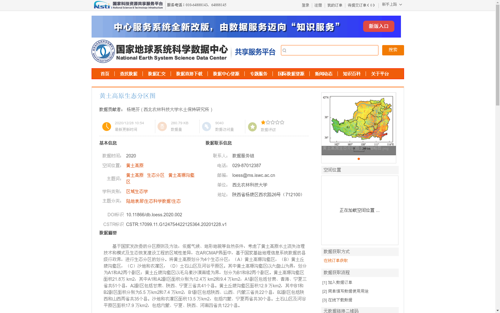
基于国家发改委的分区原则及方法,依据气候、地形地貌等自然条件,考虑了黄土高原水土流失治理技术和模式及生态恢复建设工程的区域性差异,在ARCMAP界面中,基于国家基础地理信息系统数据的县级行政界,进行生态分区的划分。将黄土高原划分为4个生态分区:(A)黄土高塬沟壑区,(B)黄土丘陵沟壑区,(C)沙地和农灌区,(D)土石山区及河谷平原区。其中黄土高塬沟壑区以六盘山为界,划分为A1和A2两个副区;黄土丘陵沟壑区以毛乌素沙漠南缘为界,划分为B1和B2两个副区。黄土高塬沟壑区面积21.8万 km2,其中A1和A2副区面积分别为12.4万 km2和9.4 万km2,A1副区包括甘肃、青海、宁夏三省共51个县,A2副区包括甘肃、陕西、宁夏三省共41个县。黄土丘陵沟壑区面积12.9 万km2,其中B1和B2副区面积分别为5.5 万km2和7.4 万km2,B1副区包括陕西、山西、内蒙三省共22个县,B2副区包括陕西和山西两省共35个县。沙地和农灌区面积13.5 万km2,包括内蒙、宁夏两省共30个县。土石山区及河谷平原区面积17.9 万km2,包括内蒙、宁夏、陕西、河南四省共122个县。
Based on the zoning principles and methods of the National Development and Reform Commission, this study carried out ecological zoning on the Loess Plateau by considering natural conditions including climate and topography, as well as regional disparities in soil erosion control technologies, models and ecological restoration construction projects. The zoning was implemented within the ArcMap interface, using county-level administrative boundary data from the National Fundamental Geographic Information System. The Loess Plateau was divided into four ecological zones: (A) Loess Plateau Gully Region, (B) Loess Hilly Gully Region, (C) Sandy Land and Agricultural Irrigation District, and (D) Rocky Mountain and River Valley Plain Region.
The Loess Plateau Gully Region was further split into two sub-zones, A1 and A2, with the Liupan Mountain as the boundary; the Loess Hilly Gully Region was divided into two sub-zones, B1 and B2, bounded by the southern margin of the Mu Us Desert.
The Loess Plateau Gully Region has a total area of 218,000 km², with sub-zones A1 and A2 covering 124,000 km² and 94,000 km² respectively. Sub-zone A1 encompasses 51 counties across three provinces: Gansu, Qinghai and Ningxia, while sub-zone A2 includes 41 counties in Gansu, Shaanxi and Ningxia.
The Loess Hilly Gully Region spans an area of 129,000 km², with sub-zones B1 and B2 accounting for 55,000 km² and 74,000 km² respectively. Sub-zone B1 covers 22 counties in Shaanxi, Shanxi and Inner Mongolia, and sub-zone B2 includes 35 counties in Shaanxi and Shanxi.
The Sandy Land and Agricultural Irrigation District has an area of 135,000 km², covering 30 counties across Inner Mongolia and Ningxia.
The Rocky Mountain and River Valley Plain Region covers an area of 179,000 km², including 122 counties in Inner Mongolia, Ningxia, Shaanxi and Henan.
提供机构:
西北农林科技大学水土保持研究所
创建时间:
2020-12-28
搜集汇总
数据集介绍
背景与挑战
背景概述
该数据集是2020年发布的黄土高原生态分区图,基于国家发改委的分区原则和方法,结合气候、地形地貌等自然条件以及水土流失治理的区域差异,在ARCMAP中利用县级行政界划分而成。它将黄土高原划分为4个主要生态分区(包括黄土高塬沟壑区、黄土丘陵沟壑区等),并进一步细分为副区,详细提供了各分区的面积、涉及省份和县数,适用于区域生态学研究和生态恢复规划。
以上内容由遇见数据集搜集并总结生成


