南京领航科技鸟瞰数据集
收藏江苏数据知识产权登记系统2025-04-14 更新2025-05-13 收录
下载链接:
https://dataip.jsipp.cn/#/changeDetialCertical?pType=登记&cType=登记&id=008849d97d4d38e125ac88b33497e738
下载链接
链接失效反馈官方服务:
资源简介:
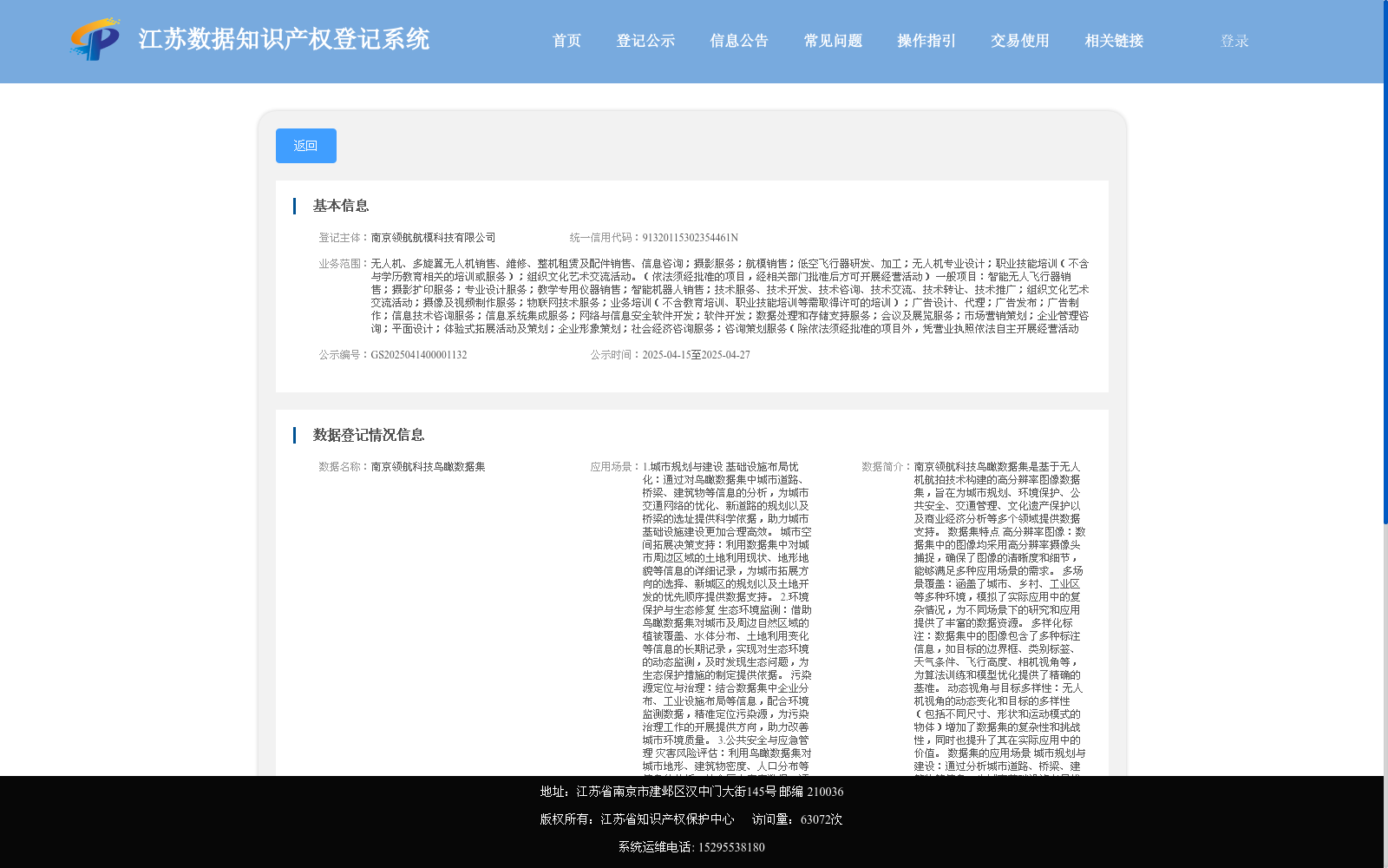
南京领航科技鸟瞰数据集是基于无人机航拍技术构建的高分辨率图像数据集,旨在为城市规划、环境保护、公共安全、交通管理、文化遗产保护以及商业经济分析等多个领域提供数据支持。
数据集特点
高分辨率图像:数据集中的图像均采用高分辨率摄像头捕捉,确保了图像的清晰度和细节,能够满足多种应用场景的需求。
多场景覆盖:涵盖了城市、乡村、工业区等多种环境,模拟了实际应用中的复杂情况,为不同场景下的研究和应用提供了丰富的数据资源。
多样化标注:数据集中的图像包含了多种标注信息,如目标的边界框、类别标签、天气条件、飞行高度、相机视角等,为算法训练和模型优化提供了精确的基准。
动态视角与目标多样性:无人机视角的动态变化和目标的多样性(包括不同尺寸、形状和运动模式的物体)增加了数据集的复杂性和挑战性,同时也提升了其在实际应用中的价值。
数据集的应用场景
城市规划与建设:通过分析城市道路、桥梁、建筑物等信息,为城市基础设施布局优化和城市空间拓展决策提供科学依据。
环境保护与生态修复:利用数据集对城市及周边自然区域的植被覆盖、水体分布、土地利用变化等信息的长期记录,实现生态环境的动态监测。
公共安全与应急管理:评估不同区域的灾害风险等级,为防灾减灾工作提供数据支持,并在灾害发生时快速规划应急救援路径。
交通管理与优化:分析交通流量变化规律,预测交通拥堵点,为交通疏导措施的制定提供支持。
文化遗产保护:对城市中的历史建筑、文化遗址等进行定期监测,及时发现其周边环境变化和自身结构损坏问题。
商业与经济分析:为商业企业选址提供数据支持,分析城市产业发展趋势,为政府制定产业政策提供决策依据。
数据集的创建与更新
创建时间:数据集于2024年首次发布
Nanjing Linghang Technology Aerial View Dataset is a high-resolution image dataset constructed via unmanned aerial vehicle (UAV) aerial photography technology, aiming to provide data support for multiple fields including urban planning, environmental protection, public safety, traffic management, cultural heritage protection, and commercial economic analysis.
### Dataset Features
1. High-resolution images: All images in the dataset are captured with high-resolution cameras, ensuring clear image quality and detailed information to meet the demands of various application scenarios.
2. Multi-scenario coverage: It covers diverse environments such as urban areas, rural regions, and industrial zones, simulating complex scenarios in real-world applications and providing rich data resources for research and applications across different scenarios.
3. Diverse annotations: The images in the dataset contain multiple types of annotation information, including target bounding boxes, category labels, weather conditions, flight altitudes, and camera perspectives, offering accurate benchmarks for algorithm training and model optimization.
4. Dynamic perspectives and diverse targets: The dynamic changes of UAV shooting perspectives and the diversity of targets (including objects with varying sizes, shapes, and motion patterns) increase the complexity and challenge of the dataset, while also enhancing its practical application value.
### Application Scenarios of the Dataset
1. Urban planning and construction: By analyzing information such as urban roads, bridges, and buildings, this dataset provides scientific basis for optimizing the layout of urban infrastructure and making decisions on urban space expansion.
2. Environmental protection and ecological restoration: Leveraging the long-term records of vegetation coverage, water body distribution, and land use changes in urban and surrounding natural areas provided by the dataset, dynamic monitoring of the ecological environment can be implemented.
3. Public safety and emergency management: It can evaluate the disaster risk levels of different regions, provide data support for disaster prevention and mitigation work, and quickly plan emergency rescue routes when disasters occur.
4. Traffic management and optimization: By analyzing the changing rules of traffic flow and predicting traffic congestion points, it provides support for formulating traffic control measures.
5. Cultural heritage protection: Regularly monitoring historical buildings and cultural sites in the city to timely detect changes in their surrounding environments and structural damage issues.
6. Commercial and economic analysis: Providing data support for commercial enterprises' site selection, analyzing urban industrial development trends, and offering decision-making basis for the government to formulate industrial policies.
### Dataset Creation and Update
Creation time: The dataset was first released in 2024.
提供机构:
南京领航航模科技有限公司
搜集汇总
数据集介绍
以上内容由遇见数据集搜集并总结生成


