Annual winter wheat mapping datasets and dynamics in China from 2001 to 2020
收藏DataCite Commons2025-04-27 更新2025-05-18 收录
下载链接:
https://www.scidb.cn/detail?dataSetId=11541911ec3a4d90975a9c88f4371ead
下载链接
链接失效反馈官方服务:
资源简介:
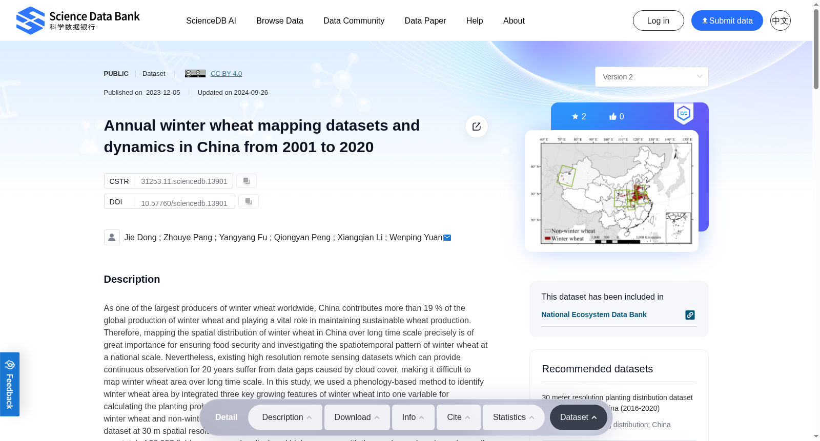
As one of the largest producers of winter wheat worldwide, China contributes more than 19 % of the global production of winter wheat and playing a vital role in maintaining sustainable wheat production. Therefore, mapping the spatial distribution of winter wheat in China over long time scale precisely is of great importance for ensuring food security and investigating the spatiotemporal pattern of winter wheat at a national scale. Nevertheless, existing high resolution remote sensing datasets which can provide continuous observation for 20 years suffer from data gaps caused by cloud cover, making it difficult to map winter wheat area over long time scale. In this study, we used a phenology-based method to identify winter wheat area by integrated three key growing features of winter wheat into one variable for calculating the planting probability of winter wheat, which enlarged phenological differences between winter wheat and non-winter wheat fields. On this basis, we produced a long-term winter wheat mapping dataset at 30 m spatial resolution in China from 2001 to 2020 using the fusion dataset. Validations based on a total of 32,957 field survey samples displayed high accuracy, with the user’s, producer’s, and overall accuracies of 91.17%, 90.92%, and 91.6% in China, respectively. Furthermore, the identified winter wheat area aggregated to the municipal- and county-level exhibited good correlations with the agricultural statistical data. Based on this dataset, we found that the winter wheat planting condition in China exhibited a high frequency of continuous planting, with 54.45% of pixels having continuously planted winter wheat for over 10 years. During the period of 2001–2020, approximately 40% of the winter wheat pixels showed significantly increasing trends, which mainly concentrated in the major production area for winter wheat, such as Shandong, Henan, and Anhui province. Conversely, less than a quarter of winter wheat pixels showed significantly decreasing trends, which distributed in central and western provinces in China.
作为全球最大的冬小麦(winter wheat)生产国之一,中国的冬小麦产量占全球冬小麦总产量的19%以上,在保障全球小麦可持续生产方面发挥着关键作用。因此,精准绘制中国长时间尺度下的冬小麦空间分布,对于保障国家粮食安全以及探究全国尺度冬小麦的时空格局具有重要意义。然而,现有可提供20年连续观测的高分辨率遥感数据集(remote sensing datasets)均存在云覆盖引发的数据缺失问题,难以开展长时间尺度的冬小麦面积遥感制图。本研究采用物候学方法(phenology-based method),将冬小麦的三个关键生长特征整合为单一变量以计算冬小麦种植概率,放大了冬小麦与非冬小麦地块的物候差异。在此基础上,本研究利用遥感融合数据集,生成了2001—2020年中国区域30米空间分辨率的长期冬小麦空间制图数据集。基于总计32957份野外调查样本的精度验证结果表明,本数据集具备较高的分类精度:全国尺度下的用户精度、生产者精度及总体精度分别为91.17%、90.92%与91.6%。此外,汇总至市、县级尺度的冬小麦种植面积,与农业统计数据表现出良好的相关性。基于该数据集,本研究发现中国冬小麦种植呈现出较高的连作频率:54.45%的像素(pixel)连续种植冬小麦的时长超过10年。在2001—2020年期间,约40%的冬小麦像素呈现出显著的增长趋势,主要集中在山东、河南、安徽等冬小麦主产区。与之相反,仅不足四分之一的冬小麦像素呈现出显著的缩减趋势,分布于中国中西部省份。
提供机构:
Science Data Bank
创建时间:
2023-12-05
搜集汇总
数据集介绍
背景与挑战
背景概述
该数据集提供了中国2001年至2020年30米空间分辨率的冬小麦分布图,通过高精度验证和物候学方法生成,揭示了冬小麦种植的长期趋势和空间分布特点。
以上内容由遇见数据集搜集并总结生成


