南极冰盖表面高程时间序列(2002-2019)
收藏国家青藏高原科学数据中心2022-09-13 更新2024-03-01 收录
下载链接:
https://data.tpdc.ac.cn/zh-hans/data/d6e5a95e-01a3-4684-b73b-ddcdc536ecb3
下载链接
链接失效反馈官方服务:
资源简介:
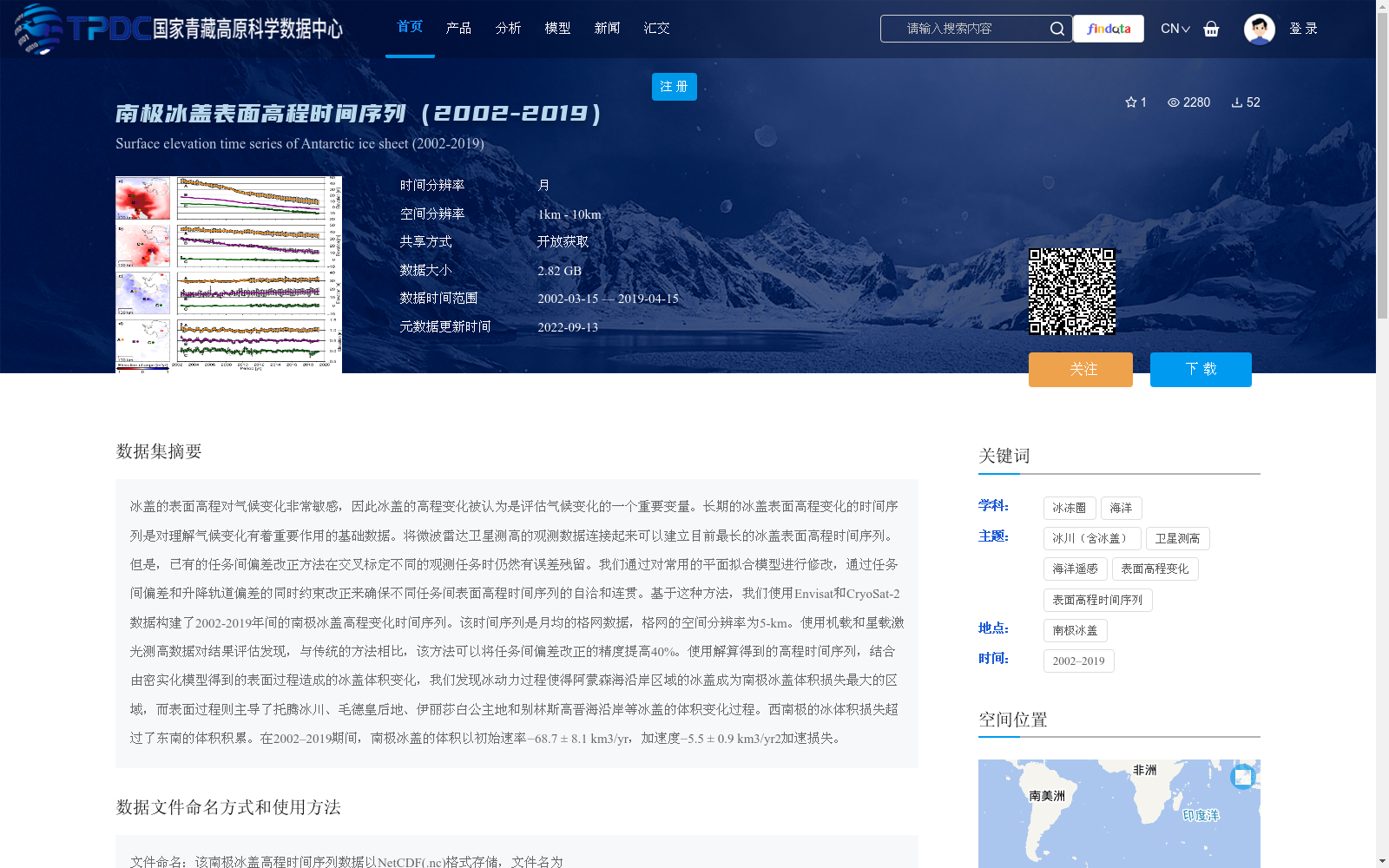
冰盖的表面高程对气候变化非常敏感,因此冰盖的高程变化被认为是评估气候变化的一个重要变量。长期的冰盖表面高程变化的时间序列是对理解气候变化有着重要作用的基础数据。将微波雷达卫星测高的观测数据连接起来可以建立目前最长的冰盖表面高程时间序列。但是,已有的任务间偏差改正方法在交叉标定不同的观测任务时仍然有误差残留。我们通过对常用的平面拟合模型进行修改,通过任务间偏差和升降轨道偏差的同时约束改正来确保不同任务间表面高程时间序列的自洽和连贯。基于这种方法,我们使用Envisat和CryoSat-2数据构建了2002-2019年间的南极冰盖高程变化时间序列。该时间序列是月均的格网数据,格网的空间分辨率为5-km。使用机载和星载激光测高数据对结果评估发现,与传统的方法相比,该方法可以将任务间偏差改正的精度提高40%。使用解算得到的高程时间序列,结合由密实化模型得到的表面过程造成的冰盖体积变化,我们发现冰动力过程使得阿蒙森海沿岸区域的冰盖成为南极冰盖体积损失最大的区域,而表面过程则主导了托腾冰川、毛德皇后地、伊丽莎白公主地和别林斯高晋海沿岸等冰盖的体积变化过程。西南极的冰体积损失超过了东南的体积积累。在2002–2019期间,南极冰盖的体积以初始速率−68.7 ± 8.1 km3/yr,加速度−5.5 ± 0.9 km3/yr2加速损失。
Ice sheet surface elevation is highly sensitive to climate change, so ice sheet elevation change is regarded as a critical variable for climate change assessment. Long-term time series of ice sheet surface elevation changes are fundamental data critical for understanding climate change. Connecting observations from microwave radar satellite altimetry can establish the longest currently available time series of ice sheet surface elevation. However, existing inter-mission bias correction methods still leave residual errors when cross-calibrating different observation missions. We modified the commonly used plane fitting model, and implemented simultaneous constraint correction for both inter-mission bias and ascending/descending orbit bias to ensure the self-consistency and coherence of surface elevation time series across different missions. Using this method, we constructed a time series of Antarctic ice sheet elevation changes between 2002 and 2019 using data from Envisat and CryoSat-2. This time series consists of monthly-averaged gridded data with a spatial resolution of 5 km. Evaluations using airborne and spaceborne laser altimetry data show that, compared with traditional methods, our method improves the accuracy of inter-mission bias correction by 40%. Using the solved elevation time series combined with ice sheet volume changes caused by surface processes derived from compaction models, we found that ice dynamic processes make the ice sheets along the Amundsen Sea Coast the region with the largest ice volume loss in Antarctica, while surface processes dominate the volume change processes of ice sheets along Totten Glacier, Queen Maud Land, Princess Elizabeth Land, and the Bellingshausen Sea Coast. Ice volume loss in West Antarctica exceeds volume accumulation in East Antarctica. During 2002–2019, the Antarctic ice sheet volume experienced accelerating loss at an initial rate of −68.7 ± 8.1 km³/yr and an acceleration of −5.5 ± 0.9 km³/yr².
提供机构:
张保军,王泽民,杨全明,柳景斌,安家春,李斐,耿红
创建时间:
2021-08-26
搜集汇总
数据集介绍
背景与挑战
背景概述
该数据集提供了2002年至2019年间南极冰盖表面高程的月均格网数据,空间分辨率为5公里,用于研究冰盖高程变化及其对气候变化的响应。数据通过改进的任务间偏差改正方法提高了精度,揭示了南极冰盖体积损失的区域差异和加速趋势。
以上内容由遇见数据集搜集并总结生成


