多龙矿集区高分5号遥感蚀变信息分布图(2019)
收藏国家青藏高原科学数据中心2025-04-14 更新2025-04-26 收录
下载链接:
https://data.tpdc.ac.cn/zh-hans/data/82648147-df9b-4a07-9caf-c2f3e6d4aa96
下载链接
链接失效反馈官方服务:
资源简介:
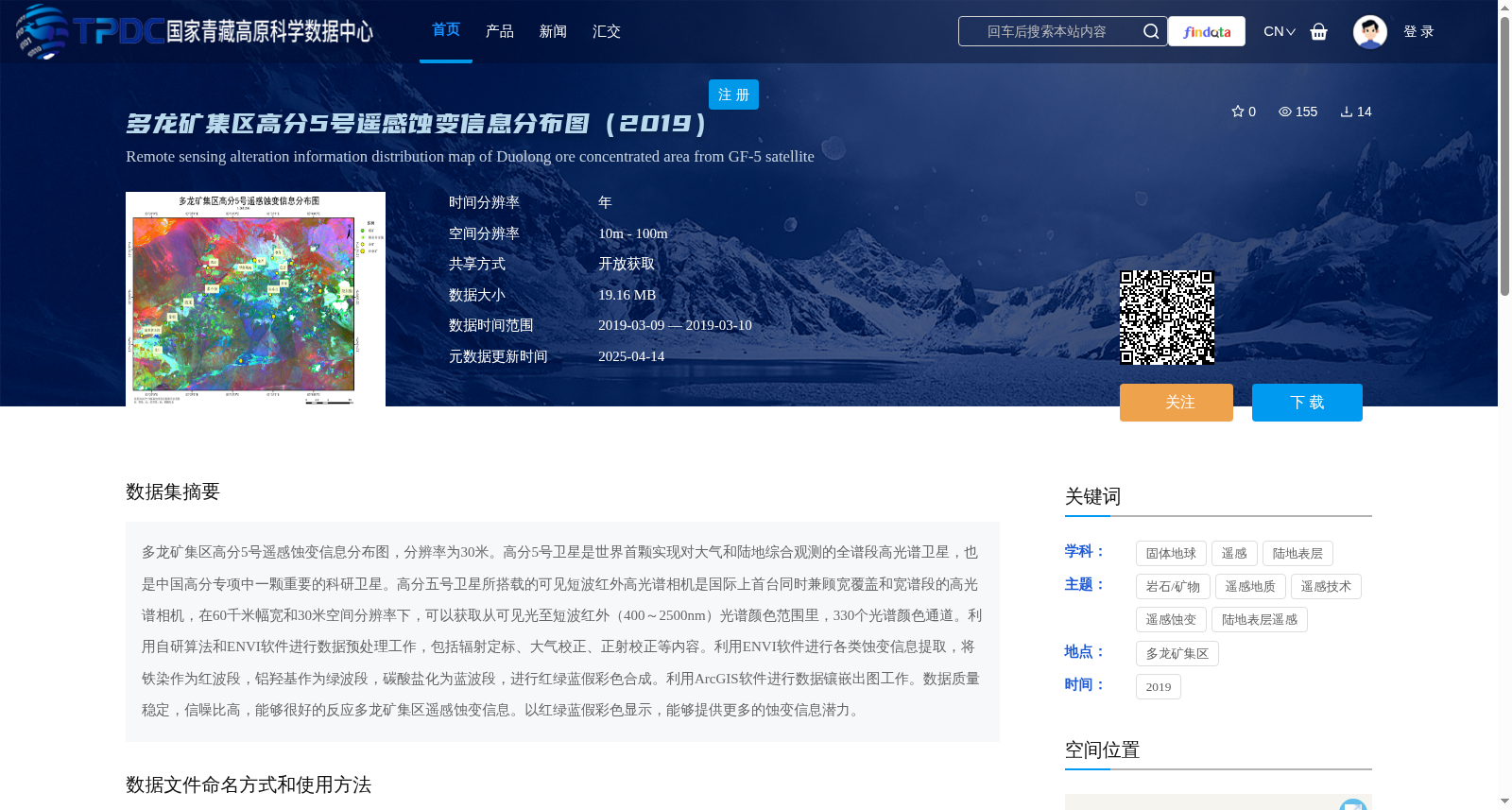
多龙矿集区高分5号遥感蚀变信息分布图,分辨率为30米。高分5号卫星是世界首颗实现对大气和陆地综合观测的全谱段高光谱卫星,也是中国高分专项中一颗重要的科研卫星。高分五号卫星所搭载的可见短波红外高光谱相机是国际上首台同时兼顾宽覆盖和宽谱段的高光谱相机,在60千米幅宽和30米空间分辨率下,可以获取从可见光至短波红外(400~2500nm)光谱颜色范围里,330个光谱颜色通道。利用自研算法和ENVI软件进行数据预处理工作,包括辐射定标、大气校正、正射校正等内容。利用ENVI软件进行各类蚀变信息提取,将铁染作为红波段,铝羟基作为绿波段,碳酸盐化为蓝波段,进行红绿蓝假彩色合成。利用ArcGIS软件进行数据镶嵌出图工作。数据质量稳定,信噪比高,能够很好的反应多龙矿集区遥感蚀变信息。以红绿蓝假彩色显示,能够提供更多的蚀变信息潜力。
Distribution map of remote sensing alteration information in Duolong ore concentration area based on GF-5 satellite, with a spatial resolution of 30 meters. GF-5 satellite is the world's first full-spectrum hyperspectral satellite capable of comprehensive observation of both atmosphere and land, and it is also an important scientific research satellite in China's Gaofen Special Project. The visible-shortwave infrared hyperspectral camera carried by GF-5 satellite is the world's first hyperspectral camera that simultaneously achieves wide coverage and wide spectral range. With a swath width of 60 km and a spatial resolution of 30 m, it can acquire 330 spectral channels in the spectral range from visible light to shortwave infrared (400–2500 nm). Data preprocessing was performed using self-developed algorithms and ENVI software, including radiometric calibration, atmospheric correction, orthorectification and other related procedures. Various alteration information was extracted using ENVI software. False-color composite of red-green-blue (RGB) was generated by assigning iron staining to the red band, aluminum hydroxyl to the green band, and carbonate alteration to the blue band. Data mosaicking and mapping were completed using ArcGIS software. The dataset features stable data quality and high signal-to-noise ratio (SNR), which can accurately reflect the remote sensing alteration information in the Duolong ore concentration area. Displayed in RGB false-color composite, this dataset exhibits great potential for providing abundant alteration information.
提供机构:
荆林海
创建时间:
2025-04-13
搜集汇总
数据集介绍
背景与挑战
背景概述
该数据集是基于高分5号卫星高光谱数据(2019年3月采集)生成的多龙矿集区遥感蚀变信息分布图,分辨率为30米,覆盖可见光至短波红外光谱范围,通过专业算法提取铁染、铝羟基和碳酸盐化蚀变信息,并以假彩色合成显示,数据质量稳定、信噪比高,适用于地质勘查和遥感研究。
以上内容由遇见数据集搜集并总结生成


