基于FY-3/MWRI的中国区域长时间序列地表冻融数据集(2010-2021)
收藏国家青藏高原科学数据中心2023-05-10 更新2024-03-07 收录
下载链接:
https://data.tpdc.ac.cn/zh-hans/data/775fcbe9-a4e3-4c0e-b266-18a3303c8b80
下载链接
链接失效反馈官方服务:
资源简介:
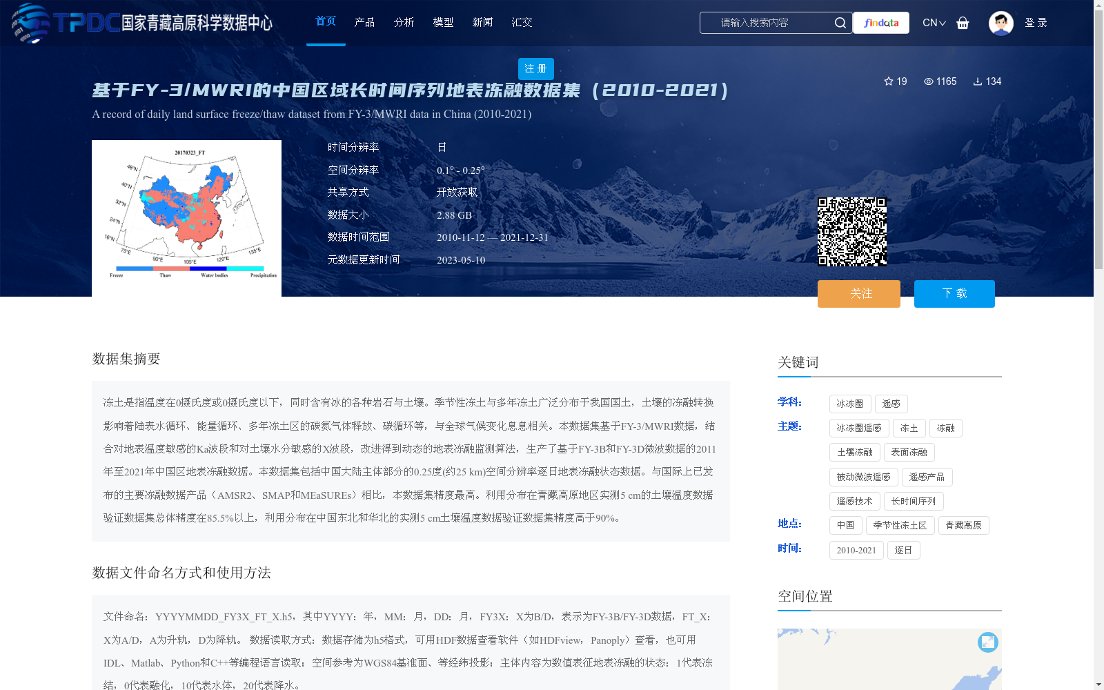
冻土是指温度在0摄氏度或0摄氏度以下,同时含有冰的各种岩石与土壤。季节性冻土与多年冻土广泛分布于我国国土,土壤的冻融转换影响着陆表水循环、能量循环、多年冻土区的碳氮气体释放、碳循环等,与全球气候变化息息相关。本数据集基于FY-3/MWRI数据,结合对地表温度敏感的Ka波段和对土壤水分敏感的X波段,改进得到动态的地表冻融监测算法,生产了基于FY-3B和FY-3D微波数据的2011年至2021年中国区地表冻融数据。本数据集包括中国大陆主体部分的0.25度(约25 km)空间分辨率逐日地表冻融状态数据。与国际上已发布的主要冻融数据产品(AMSR2、SMAP和MEaSUREs)相比,本数据集精度最高。利用分布在青藏高原地区实测5 cm的土壤温度数据验证数据集总体精度在85.5%以上,利用分布在中国东北和华北的实测5 cm土壤温度数据验证数据集精度高于90%。
Frozen soil refers to all types of rocks and soils with a temperature at or below 0°C and containing ice. Seasonally frozen ground and permafrost are widely distributed across China. The freeze-thaw transition of soils affects land surface water cycle, energy cycle, carbon and nitrogen gas emissions in permafrost regions, carbon cycle, and is closely related to global climate change. This dataset is developed based on FY-3/MWRI data. By combining the Ka-band sensitive to surface temperature and the X-band sensitive to soil moisture, we improved a dynamic surface freeze-thaw monitoring algorithm, and produced the surface freeze-thaw data over China from 2011 to 2021 based on FY-3B and FY-3D microwave data. This dataset includes daily surface freeze-thaw status data with a spatial resolution of 0.25 degrees (approximately 25 km) for the main part of mainland China. Compared with major internationally released freeze-thaw data products (AMSR2, SMAP and MEaSUREs), this dataset has the highest accuracy. The overall accuracy of this dataset verified using in-situ 5 cm soil temperature data across the Qinghai-Tibet Plateau is above 85.5%, while the accuracy verified using in-situ 5 cm soil temperature data across Northeast and North China exceeds 90%.
提供机构:
蒋玲梅,王健,武胜利,孙凌,张鹏
创建时间:
2023-04-21
搜集汇总
数据集介绍
背景与挑战
背景概述
该数据集是基于FY-3/MWRI卫星数据生产的中国区域长时间序列地表冻融数据集,覆盖2010年至2021年,具有逐日时间分辨率和0.25度空间分辨率。数据集采用改进的动态冻融监测算法,精度高(总体验证精度超过85.5%,部分地区达90%以上),并提供了冻结、融化、水体和降水等状态分类,数据以HDF5格式存储,大小为2.88 GB,适用于冰冻圈遥感和气候变化研究。
以上内容由遇见数据集搜集并总结生成


