东北多年冻土分布与概率数据集(2000-2020)
收藏国家青藏高原科学数据中心2025-05-14 更新2025-07-12 收录
下载链接:
https://data.tpdc.ac.cn/zh-hans/data/da9e25fd-3deb-4d83-8184-2474480420d5
下载链接
链接失效反馈官方服务:
资源简介:
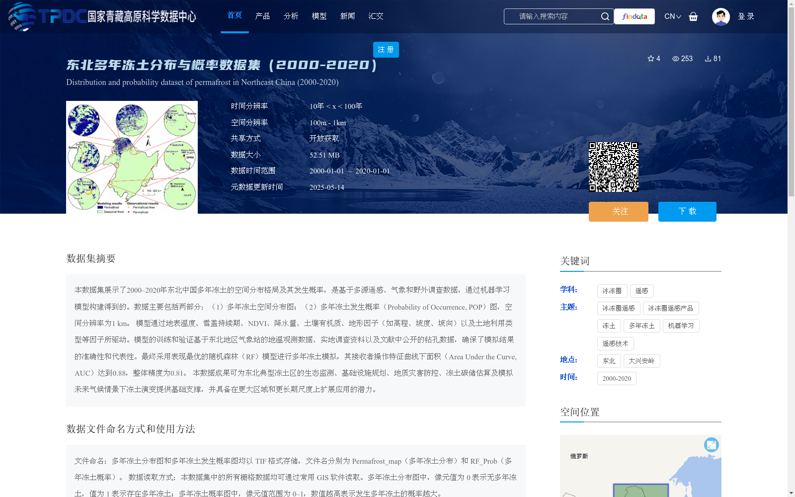
本数据集展示了2000–2020年东北中国多年冻土的空间分布格局及其发生概率,是基于多源遥感、气象和野外调查数据,通过机器学习模型构建得到的。数据主要包括两部分:(1)多年冻土空间分布图;(2)多年冻土发生概率(Probability of Occurrence, POP)图,空间分辨率为1 km。
模型通过地表温度、雪盖持续期、NDVI、降水量、土壤有机质、地形因子(如高程、坡度、坡向)以及土地利用类型等因子所驱动。模型的训练和验证基于东北地区气象站的地温观测数据、实地调查资料以及文献中公开的钻孔数据,确保了模拟结果的准确性和代表性。最终采用表现最优的随机森林(RF)模型进行多年冻土模拟,其接收者操作特征曲线下面积(Area Under the Curve, AUC)达到0.88,整体精度为0.81。
本数据成果可为东北典型冻土区的生态监测、基础设施规划、地质灾害防控、冻土碳储估算及模拟未来气候情景下冻土演变提供基础支撑,并具备在更大区域和更长期尺度上扩展应用的潜力。
This dataset presents the spatial distribution pattern and occurrence probability of permafrost in Northeast China from 2000 to 2020, which was constructed using machine learning models based on multi-source remote sensing, meteorological and field survey data. The dataset mainly includes two parts: (1) Spatial distribution map of permafrost; (2) Map of Permafrost Probability of Occurrence (POP), with a spatial resolution of 1 km.
The model is driven by factors such as land surface temperature, snow cover duration, NDVI, precipitation, soil organic matter, topographic factors (e.g., elevation, slope, aspect) and land use type. The training and validation of the model are based on in-situ ground temperature observation data from meteorological stations in Northeast China, field survey data and publicly available borehole data from literature, ensuring the accuracy and representativeness of the simulation results. Finally, the best-performing Random Forest (RF) model was adopted for permafrost simulation, with its Area Under the Receiver Operating Characteristic Curve (AUC) reaching 0.88 and overall accuracy of 0.81.
This dataset can provide fundamental support for ecological monitoring, infrastructure planning, geological disaster prevention and control, permafrost carbon storage estimation, and simulation of permafrost evolution under future climate scenarios in typical permafrost regions of Northeast China, and has the potential to be expanded for applications in larger regions and longer time scales.
提供机构:
黄帅,金会军
创建时间:
2025-05-12
搜集汇总
数据集介绍
背景与挑战
背景概述
该数据集提供了2000-2020年中国东北地区多年冻土的空间分布和发生概率信息,基于多源数据并通过随机森林机器学习模型构建,空间分辨率为1公里,模型精度较高(AUC 0.88)。数据以TIF格式存储,适用于生态监测、基础设施规划等应用,并支持开放获取。
以上内容由遇见数据集搜集并总结生成


