北极陆地自然灾害风险数据集
收藏国家青藏高原科学数据中心2025-08-13 更新2025-09-06 收录
下载链接:
https://data.tpdc.ac.cn/zh-hans/data/12761848-d7bf-42e2-ba46-f18b28708efa
下载链接
链接失效反馈官方服务:
资源简介:
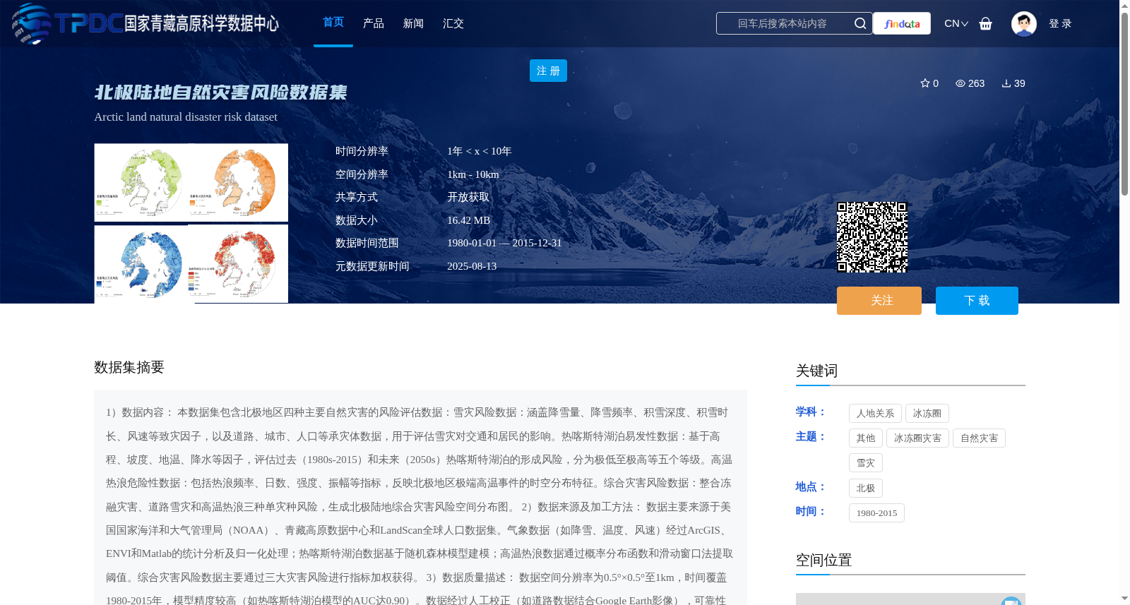
1)数据内容:
本数据集包含北极地区四种主要自然灾害的风险评估数据:
雪灾风险数据:涵盖降雪量、降雪频率、积雪深度、积雪时长、风速等致灾因子,以及道路、城市、人口等承灾体数据,用于评估雪灾对交通和居民的影响。
热喀斯特湖泊易发性数据:基于高程、坡度、地温、降水等因子,评估过去(1980s-2015)和未来(2050s)热喀斯特湖泊的形成风险,分为极低至极高等五个等级。
高温热浪危险性数据:包括热浪频率、日数、强度、振幅等指标,反映北极地区极端高温事件的时空分布特征。
综合灾害风险数据:整合冻融灾害、道路雪灾和高温热浪三种单灾种风险,生成北极陆地综合灾害风险空间分布图。
2)数据来源及加工方法:
数据主要来源于美国国家海洋和大气管理局(NOAA)、青藏高原数据中心和LandScan全球人口数据集。气象数据(如降雪、温度、风速)经过ArcGIS、ENVI和Matlab的统计分析及归一化处理;热喀斯特湖泊数据基于随机森林模型建模;高温热浪数据通过概率分布函数和滑动窗口法提取阈值。综合灾害风险数据主要通过三大灾害风险进行指标加权获得。
3)数据质量描述:
数据空间分辨率为0.5°×0.5°至1km,时间覆盖1980-2015年,模型精度较高(如热喀斯特湖泊模型的AUC达0.90)。数据经过人工校正(如道路数据结合Google Earth影像),可靠性较强。
4)数据应用成果及前景:
该数据集已用于北极灾害风险评估、气候变化研究和区域规划。未来可支持北极基础设施韧性优化、灾害预警系统开发及国际政策制定,为北极可持续发展提供科学依据。
1) Data Content:
This dataset encompasses risk assessment data for four major natural disasters in the Arctic region:
- Snow disaster risk data: Covers hazard-inducing factors including snowfall amount, snowfall frequency, snow depth, snow cover duration, and wind speed, as well as disaster-bearing body data such as roads, urban areas, and population, to evaluate the impacts of snow disasters on transportation and local residents.
- Thermokarst lake susceptibility data: Based on factors such as elevation, slope, ground temperature, and precipitation, it assesses the formation risks of thermokarst lakes during the past period (1980s–2015) and future period (2050s), which is categorized into five levels ranging from extremely low to extremely high.
- High-temperature heatwave hazard data: Includes indicators like heatwave frequency, duration, intensity, and amplitude, reflecting the spatiotemporal distribution characteristics of extreme high-temperature events across the Arctic region.
- Comprehensive disaster risk data: Integrates the risks of three single-type disasters, namely freeze-thaw disasters, road snow disasters, and high-temperature heatwaves, to generate a spatial distribution map of comprehensive disaster risk over Arctic terrestrial areas.
2) Data Sources and Processing Methods:
The dataset is primarily sourced from the National Oceanic and Atmospheric Administration (NOAA), the Qinghai-Tibet Plateau Data Center, and the LandScan Global Population Dataset. Meteorological data (e.g., snowfall, temperature, and wind speed) has undergone statistical analysis and normalization processing using ArcGIS, ENVI, and Matlab; thermokarst lake data is modeled via the Random Forest algorithm; high-temperature heatwave data extracts threshold values using probability distribution functions and the sliding window method. The comprehensive disaster risk data is mainly obtained through index weighting of the three aforementioned single disaster risks.
3) Data Quality Description:
The data has a spatial resolution ranging from 0.5°×0.5° to 1 km, with a temporal coverage spanning from 1980 to 2015. The model accuracy is relatively high, with the AUC of the thermokarst lake model reaching 0.90, for example. The data has been manually corrected (e.g., road data has been verified and aligned with Google Earth imagery), resulting in strong reliability.
4) Data Application Achievements and Prospects:
This dataset has been applied to Arctic disaster risk assessment, climate change research, and regional planning. In the future, it can support the optimization of Arctic infrastructure resilience, the development of disaster early warning systems, and the formulation of international policies, providing scientific evidence for the sustainable development of the Arctic.
提供机构:
刘吉夫,朱文泉
创建时间:
2025-08-12
搜集汇总
数据集介绍
背景与挑战
背景概述
该数据集提供北极地区1980年至2015年的自然灾害风险评估数据,涵盖雪灾、热喀斯特湖泊易发性、高温热浪和综合灾害风险四种类型,空间分辨率为0.5°×0.5°至1km。数据基于多源数据(如NOAA和青藏高原数据中心)通过统计分析(如ArcGIS)和机器学习模型(如随机森林)加工,模型精度高(如热喀斯特湖泊AUC达0.90),适用于北极灾害风险评估、气候变化研究和区域可持续发展规划。
以上内容由遇见数据集搜集并总结生成


