中国土遗址冻融环境区划地图(1970-2022)
收藏国家青藏高原科学数据中心2025-03-22 更新2025-04-19 收录
下载链接:
https://data.tpdc.ac.cn/zh-hans/data/51313fb9-1002-44a7-84d1-459f123aa4bb
下载链接
链接失效反馈官方服务:
资源简介:
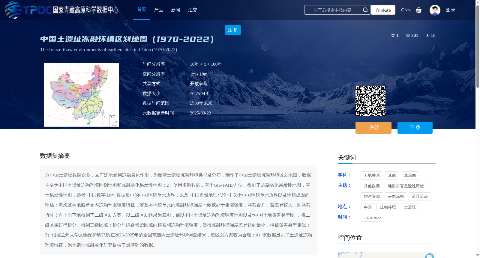
1) 中国土遗址数目众多,且广泛地受到冻融劣化作用,为厘清土遗址冻融环境类型及分布,制作了中国土遗址冻融环境区划地图,数据主要为中国土遗址冻融环境区划地图和冻融劣化易发性地图;2)使用多源数据,基于GIS-FAHP方法,得到了冻融劣化易发性地图,基于易发性地图,参考“中国数字山地”数据集中的中国地貌单元边界,以及“中国自然地理总论”中关于中国地貌单元边界以及地貌成因的论述;考虑基本地貌单元内冻融环境强度特征,若基本地貌单元内冻融环境强度一致或处于相邻强度,将其合并,若差异较大,则将其拆分;自上而下地得到了二级区划方案。以二级区划结果为底图,辅以中国土遗址冻融环境强度地图以及“中国土地覆盖类型图”,将二级区域进行拆分,得到三级区域;拆分时综合考虑区域内植被和冻融环境强度,使得冻融环境强度差异达到最小,植被覆盖类型相似;3)根据兰州大学文物保护研究所在2023-2025年的全国范围内土遗址环境调查结果,该区划方案较为合理;4)该数据显示了土遗址冻融环境特征,为土遗址冻融劣化研究提供了最基础的数据。
1) China boasts a large number of earthen heritage sites, which are extensively affected by freeze-thaw degradation. To clarify the types and distribution of freeze-thaw environments for these sites, a zoning map of freeze-thaw environments for earthen heritage sites across China was compiled. The core data of this dataset include the China Earthen Heritage Site Freeze-Thaw Environment Zoning Map and the Freeze-Thaw Degradation Susceptibility Map.
2) Leveraging multi-source data and the GIS-FAHP method, the Freeze-Thaw Degradation Susceptibility Map was derived. Drawing on this susceptibility map, references were made to the boundaries of China's geomorphic units from the "China Digital Mountain" dataset, as well as the discussions on geomorphic unit boundaries and geomorphic genesis in *General Introduction to Physical Geography of China*. Considering the intensity characteristics of freeze-thaw environments within basic geomorphic units, units with consistent or adjacent freeze-thaw environment intensities were merged, while those with substantial differences were split; a secondary zoning scheme was thus obtained top-down. Taking the secondary zoning results as the base map, and supplemented by the China Earthen Heritage Site Freeze-Thaw Environment Intensity Map and the "China Land Cover Type Map", the secondary regions were further subdivided to generate tertiary regions. During the subdivision process, vegetation cover and freeze-thaw environment intensities within each region were comprehensively considered to minimize the variation in freeze-thaw environment intensities and ensure similar vegetation cover types.
3) This zoning scheme has been verified to be relatively reasonable based on the national earthen heritage site environment survey conducted by the Cultural Heritage Conservation Research Institute of Lanzhou University from 2023 to 2025.
4) This dataset characterizes the freeze-thaw environment features of earthen heritage sites, providing fundamental data for research on freeze-thaw degradation of such sites.
提供机构:
谌文武,王科玉
创建时间:
2025-03-06
搜集汇总
数据集介绍
背景与挑战
背景概述
该数据集提供了1970-2022年中国土遗址冻融环境区划地图和冻融劣化易发性地图,空间分辨率为1m-10m,时间分辨率为10年<x<100年,数据大小为70.75MB,采用开放获取共享方式。数据集基于GIS-FAHP方法制作,结合多源数据,包括中国地貌单元边界、土遗址冻融环境强度地图等,为土遗址冻融劣化研究提供了基础数据。
以上内容由遇见数据集搜集并总结生成


