北半球多年冻土气候-生态系统敏感性分区图(2000-2016)
收藏地球大数据科学工程2024-05-01 收录
下载链接:
https://data.casearth.cn/sdo/detail/6538a136819aec0f2611ce3a
下载链接
链接失效反馈官方服务:
资源简介:
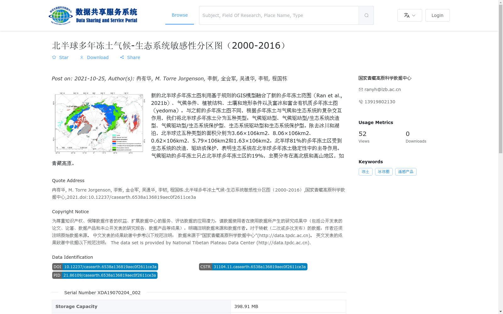
新的北半球多年冻土图利用基于规则的GIS模型融合了新的多年冻土范围(Ran et al., 2021b)、气候条件、植被结构、土壤和地形条件以及富冰和富含有机质多年冻土图(yedoma)。与之前的多年冻土图不同,根据多年冻土与气候和生态系统的复杂交互作用,我们将北半球多年冻土分为五种类型:气候驱动型、气候驱动型/生态系统改造型、气候驱动型/生态系统保护型、生态系统驱动型和生态系统保护型。除去冰川和湖泊,北半球这五种类型的面积分别为3.66×106km2、8.06×106km2、0.62×106km2、5.79×106km2和1.63×106km2。北半球81%的多年冻土区受到生态系统的改造、驱动或保护,表明生态系统在北半球多年冻土稳定性中的主导作用。气候驱动的多年冻土只占北半球多年冻土区的19%,主要分布在高北极和高山地区,如青藏高原。
The new Northern Hemisphere permafrost map integrates new permafrost extent (Ran et al., 2021b), climatic conditions, vegetation structure, soil and topographic conditions, as well as ice-rich and organic-rich permafrost maps (yedoma) using a rule-based GIS model. Unlike previous permafrost maps, we classify Northern Hemisphere permafrost into five types based on the complex interactions between permafrost, climate and ecosystems: climate-driven, climate-driven/ecosystem-modified, climate-driven/ecosystem-protected, ecosystem-driven, and ecosystem-protected. Excluding glaciers and lakes, the areas of these five permafrost types in the Northern Hemisphere are 3.66×10^6 km², 8.06×10^6 km², 0.62×10^6 km², 5.79×10^6 km², and 1.63×10^6 km², respectively. Eighty-one percent of Northern Hemisphere permafrost regions are modified, driven, or protected by ecosystems, indicating the dominant role of ecosystems in the stability of Northern Hemisphere permafrost. Climate-driven permafrost accounts for only 19% of Northern Hemisphere permafrost regions, mainly distributed in the High Arctic and alpine regions such as the Tibetan Plateau.
提供机构:
国家青藏高原科学数据中心
搜集汇总
数据集介绍
背景与挑战
背景概述
该数据集是北半球多年冻土的气候-生态系统敏感性分区图,覆盖2000-2016年,基于GIS模型融合了多年冻土范围、气候、植被和地形等因素,将多年冻土分为五种类型(如气候驱动型和生态系统驱动型),并量化了各类型的面积分布。数据显示北半球81%的多年冻土区受生态系统影响,突显了生态系统在多年冻土稳定性中的关键作用;数据集以矢量格式(shp)提供,空间分辨率为1km-10km,适用于冰冻圈和遥感研究。
以上内容由遇见数据集搜集并总结生成


