DIDLM: A SLAM Dataset for Difficult Scenarios Featuring Infrared, Depth Cameras, LIDAR, 4D Radar, and Others under Adverse Weather, Low Light Conditions, and Rough Roads
收藏DataCite Commons2026-03-18 更新2025-04-16 收录
下载链接:
https://www.scidb.cn/detail?dataSetId=282344289e1546b7a8f8ba2a34338a8c
下载链接
链接失效反馈官方服务:
资源简介:
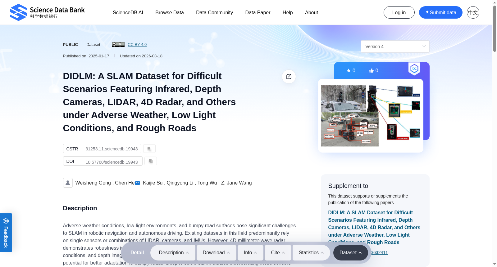
Adverse weather conditions, low-light environments, and bumpy road surfaces pose significant challenges to SLAM in robotic navigation and autonomous driving. Existing datasets in this field predominantly rely on single sensors or combinations of LiDAR, cameras, and IMUs. However, 4D millimeter-wave radar demonstrates robustness in adverse weather, infrared cameras excel in capturing details under low-light conditions, and depth images provide richer spatial information. Multi-sensor fusion methods also show potential for better adaptation to bumpy roads. Despite some SLAM studies incorporating these sensors and conditions, there remains a lack of comprehensive datasets addressing low-light environments and bumpy road conditions, or featuring a sufficiently diverse range of sensor data.In this study, we introduce a multi-sensor dataset covering challenging scenarios such as snowy weather, rainy weather, nighttime conditions, speed bumps, and rough terrains. The dataset includes rarely utilized sensors for extreme conditions, such as 4D millimeter-wave radar, infrared cameras, and depth cameras, alongside 3D LiDAR, RGB cameras, GPS, and IMU. It supports both autonomous driving and ground robot applications and provides reliable GPS/INS ground truth data, covering structured and semi-structured terrains.We evaluated various SLAM algorithms using this dataset, including RGB images, infrared images, depth images, LiDAR, and 4D millimeter-wave radar. The dataset spans a total of 18.5 km, 69 minutes, and approximately 660 GB, offering a valuable resource for advancing SLAM research under complex and extreme conditions.
恶劣天气、低光照环境与颠簸路面,对机器人导航与自动驾驶领域中的同步定位与建图(Simultaneous Localization and Mapping,SLAM)构成了显著挑战。该领域现有数据集大多依赖单传感器,或激光雷达(LiDAR)、相机与惯性测量单元(Inertial Measurement Unit,IMU)的组合方案。然而,4D毫米波雷达(4D millimeter-wave radar)在恶劣天气下展现出优异鲁棒性,红外相机(infrared camera)擅长在低光照条件下捕捉细节信息,深度图像(depth image)则可提供更丰富的空间特征。多传感器融合方法也具备更强的颠簸路面适配潜力。尽管已有部分SLAM研究引入了上述传感器并覆盖相关场景,但目前仍缺乏针对低光照环境与颠簸路面的综合性数据集,或是传感器数据种类足够丰富的数据集。
本研究推出一款多传感器数据集,涵盖降雪、降雨、夜间场景、减速带与崎岖地形等复杂工况。该数据集纳入了极端场景下鲜有应用的传感器,包括4D毫米波雷达、红外相机与深度相机,同时搭配三维激光雷达(3D LiDAR)、RGB相机、全球定位系统(Global Positioning System,GPS)与惯性测量单元(IMU)。本数据集可适配自动驾驶与地面机器人两类应用场景,并提供可靠的GPS/惯性导航系统(Inertial Navigation System,INS)真值数据,覆盖结构化与半结构化地形。
我们基于本数据集对多款SLAM算法开展了评测,涵盖RGB图像、红外图像、深度图像、激光雷达与4D毫米波雷达等输入模态。该数据集总里程达18.5公里,总时长69分钟,总数据量约660GB,可为复杂极端场景下的SLAM研究提供极具价值的支撑资源。
提供机构:
Science Data Bank
创建时间:
2025-01-17
搜集汇总
数据集介绍
背景与挑战
背景概述
DIDLM是一个专注于困难场景的SLAM多传感器数据集,覆盖雪天、雨天、夜间、减速带和粗糙地形等恶劣条件,旨在弥补现有数据集在低光环境和颠簸道路方面的不足。数据集包含4D毫米波雷达、红外相机、深度相机、3D LiDAR、RGB相机、GPS和IMU等多种传感器,提供GPS/INS地面真值数据,总规模达970.64GB,支持自动驾驶和地面机器人应用,为复杂极端条件下的SLAM研究提供宝贵资源。
以上内容由遇见数据集搜集并总结生成


