基于卫星重力的中国区域陆地水和地下水储量变化产品(2002-2022)
收藏国家青藏高原科学数据中心2024-06-06 更新2024-03-06 收录
下载链接:
https://data.tpdc.ac.cn/zh-hans/data/7fe70fa6-5e34-497c-ac01-729c602e4663
下载链接
链接失效反馈官方服务:
资源简介:
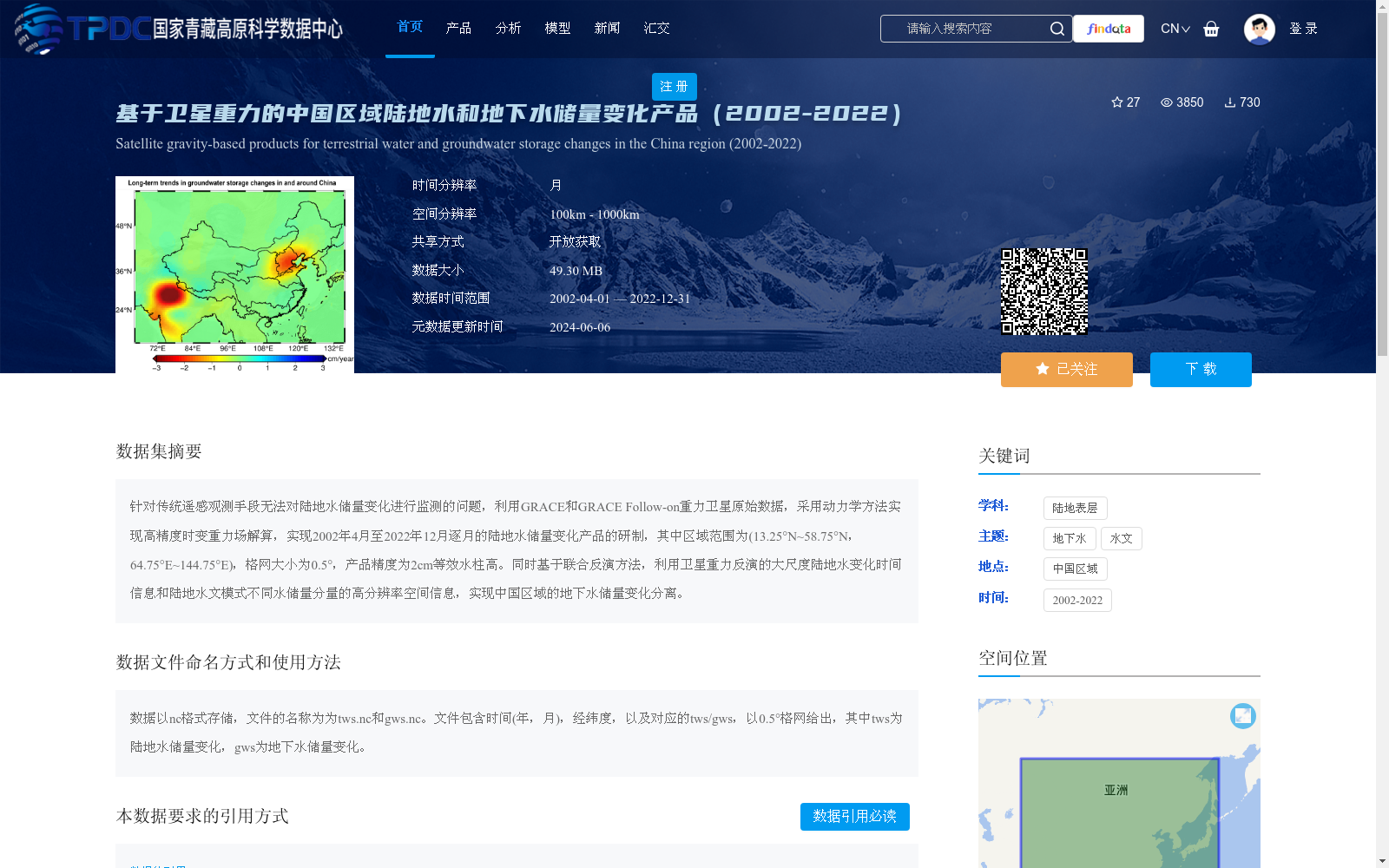
针对传统遥感观测手段无法对陆地水储量变化进行监测的问题,利用GRACE和GRACE Follow-on重力卫星原始数据,采用动力学方法实现高精度时变重力场解算,实现2002年4月至2022年12月逐月的陆地水储量变化产品的研制,其中区域范围为(13.25°N~58.75°N,64.75°E~144.75°E),格网大小为0.5°,产品精度为2cm等效水柱高。同时基于联合反演方法,利用卫星重力反演的大尺度陆地水变化时间信息和陆地水文模式不同水储量分量的高分辨率空间信息,实现中国区域的地下水储量变化分离。
To address the limitation that traditional remote sensing observation techniques cannot monitor terrestrial water storage changes, this dataset uses raw data from the GRACE and GRACE Follow-on gravity satellites, adopts dynamic methods to derive high-precision time-variable gravity field solutions, and develops monthly terrestrial water storage change products covering the period from April 2002 to December 2022. The spatial scope of the products is (13.25°N to 58.75°N, 64.75°E to 144.75°E), with a grid resolution of 0.5°, and the product accuracy is 2 cm equivalent water height. Meanwhile, based on the joint inversion method, by utilizing the large-scale temporal information of terrestrial water changes retrieved from satellite gravity and the high-resolution spatial information of various water storage components from land hydrological models, the separation of groundwater storage changes over China is achieved.
提供机构:
熊宇昊,冯伟
创建时间:
2023-07-05
搜集汇总
数据集介绍
背景与挑战
背景概述
该数据集是基于GRACE和GRACE Follow-on重力卫星数据研制的中国区域陆地水和地下水储量变化产品,覆盖2002年4月至2022年12月,提供逐月、0.5°格网分辨率的变化信息,精度达2cm等效水柱高。它通过动力学方法和联合反演技术,不仅监测大尺度陆地水储量变化,还分离出地下水储量变化,以nc格式存储,适用于水文和环境研究。
以上内容由遇见数据集搜集并总结生成


