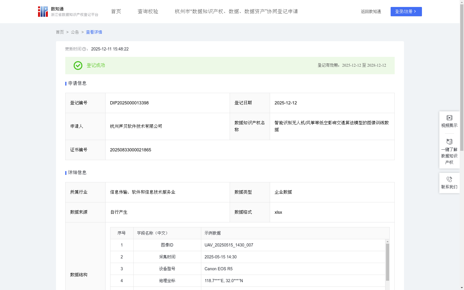
智能识别无人机/风筝等低空影响交通算法模型的图像训练数据
收藏浙江省数据知识产权登记平台2025-12-11 更新2025-12-13 收录
下载链接:
https://www.zjip.org.cn/home/announce/trends/8412839
下载链接
链接失效反馈官方服务:
资源简介:
本数据集主要用于提升AI模型对低空飞行物影响交通行为的识别能力与精确性。通过对该数据集的训练,使AI模型能够精准识别无人机、风筝、气球等低空飞行物,并可应用于机场净空区、城市主干道、高速公路等重点交通区域的监控场景。同时,本数据集可为低空安全管理、交通预警等智慧城市建设项目提供决策依据,提升航空与道路交通安全保障能力。
1.数据采集
通过企业自有摄像设备自行采集无人机、风筝等飞行物图像,同步记录图像ID、采集时间、设备型号、地理坐标、光照条件、天气状况等数据。
2.数据预处理与标注
通过数据清洗剔除模糊、重复图像。按7:2:1比例划分训练集/验证集/测试集。设置多级标注体系:
一级标签:无飞行物/有飞行物
二级标签:无人机/风筝/气球/其他飞行物
辅助标注:飞行物边界框坐标。
3.模型选择与初始化
采用YOLOv8预训练模型,初始化参数并优化超参数:学习率0.001-0.0001动态调整,批量大小1-16动态调整,锚框参数适配各类飞行物形态;集成运动轨迹分析模块提升识别准确率。
4.模型训练
基于PyTorch实施分布式训练,采用混合精度训练(FP16)提升效率。设置训练时长,数据增强模拟复杂场景,添加云层干扰、强光反射等特效,模拟不同天气条件。设置早停机制(patience=15),梯度裁剪:max_norm=1.0。
5.模型评估
在训练模型的过程中,使用验证集调整超参数,训练完成后在测试集上评估模型表现,评估指标包含:
基础性能指标:mAP@0.5、误报率
场景鲁棒性测试:复杂背景干扰下的识别准确率
并设置渐进式测试:单一飞行物识别→多飞行物场景,静止状态→高速移动状态
This dataset is primarily designed to enhance the recognition capability and accuracy of AI models in identifying low-altitude flying objects and their impacts on traffic behaviors. Trained on this dataset, AI models can accurately recognize low-altitude flying objects such as drones, kites, balloons and other similar targets, and the dataset can be applied to monitoring scenarios in key traffic areas including airport clearance zones, urban main roads and expressways. Meanwhile, this dataset can provide decision-making support for smart city construction projects such as low-altitude safety management and traffic early warning, thereby improving the guarantee capability of aviation and road traffic safety.
1. Data Collection
Images of flying objects such as drones and kites are collected using the enterprise's own camera equipment, while data including image ID, collection time, device model, geographic coordinates, lighting conditions and weather conditions are synchronously recorded.
2. Data Preprocessing and Annotation
Blurred and duplicate images are removed via data cleaning. The dataset is split into training, validation and test sets at a ratio of 7:2:1. A multi-level annotation system is established:
- Primary labels: "No flying object / Flying object present"
- Secondary labels: "Drone / Kite / Balloon / Other flying objects"
- Auxiliary annotations: Bounding box coordinates of flying objects
3. Model Selection and Initialization
A pre-trained YOLOv8 model is adopted, with initialized parameters and optimized hyperparameters: dynamically adjusted learning rate ranging from 0.001 to 0.0001, dynamically adjusted batch size ranging from 1 to 16, anchor box parameters adapted to various flying object shapes; a motion trajectory analysis module is integrated to improve recognition accuracy.
4. Model Training
Distributed training is implemented based on PyTorch, with mixed-precision training (FP16) adopted to improve efficiency. Training duration is set, and data augmentation is used to simulate complex scenarios, including adding effects such as cloud interference and strong light reflection to simulate different weather conditions. An early stopping mechanism (patience=15) is set, and gradient clipping is applied with max_norm=1.0.
5. Model Evaluation
During model training, the validation set is used to adjust hyperparameters. After training is completed, model performance is evaluated on the test set. The evaluation metrics include:
- Basic performance indicators: mAP@0.5, false positive rate
- Scene robustness test: Recognition accuracy under complex background interference
- Progressive testing: Single flying object recognition → Multiple flying object scenarios, static state → high-speed moving state
提供机构:
杭州声贝软件技术有限公司
创建时间:
2025-08-03
搜集汇总
数据集介绍
背景与挑战
背景概述
该数据集是一个用于训练AI模型识别低空飞行物(如无人机、风筝、气球)的图像训练数据,包含584条记录,每日更新,数据结构涵盖图像ID、采集时间、标签和性能指标等字段。它专为提升交通监控场景中的识别精确性设计,适用于机场净空区、城市主干道等区域,支持低空安全管理和智慧城市应用,并基于YOLOv8模型实现,评估指标显示mAP@0.5达到0.90、误报率为3.8%。
以上内容由遇见数据集搜集并总结生成


