青藏高原边界数据总集
收藏国家青藏高原科学数据中心2022-04-18 更新2024-03-01 收录
下载链接:
https://data.tpdc.ac.cn/zh-hans/data/61701a2b-31e5-41bf-b0a3-607c2a9bd3b3
下载链接
链接失效反馈官方服务:
资源简介:
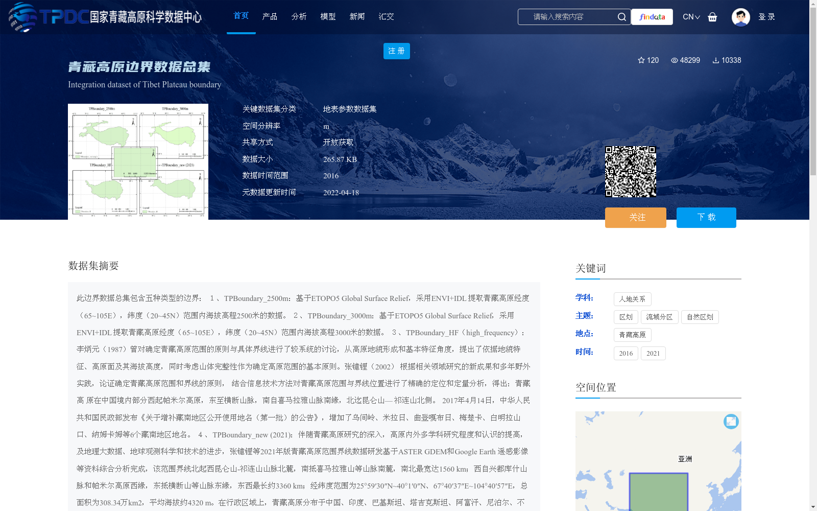
此边界数据总集包含五种类型的边界:
1、TPBoundary_2500m:基于ETOPO5 Global Surface Relief,采用ENVI+IDL 提取青藏高原经度(65~105E),纬度(20~45N)范围内海拔高程2500米的数据。
2、TPBoundary_3000m:基于ETOPO5 Global Surface Relief,采用ENVI+IDL 提取青藏高原经度(65~105E),纬度(20~45N)范围内海拔高程3000米的数据。
3、TPBoundary_HF(high_frequency):李炳元(1987)曾对确定青藏高原范围的原则与具体界线进行了较系统的讨论,从高原地貌形成和基本特征角度,提出了依据地貌特征、高原面及其海拔高度,同时考虑山体完整性作为确定高原范围的基本原则。张镱锂(2002) 根据相关领域研究的新成果和多年野外实践,论证确定青藏高原范围和界线的原则, 结合信息技术方法对青藏高原范围与界线位置进行了精确的定位和定量分析,得出:青藏高 原在中国境内部分西起帕米尔高原,东至横断山脉,南自喜马拉雅山脉南缘,北迄昆仑山— 祁连山北侧。
2017年4月14日,中华人民共和国民政部发布《关于增补藏南地区公开使用地名(第一批)的公告》,增加了乌间岭、米拉日、曲登嘎布日、梅楚卡、白明拉山口、纳姆卡姆等6个藏南地区地名。
4、TPBoundary_new (2021):伴随青藏高原研究的深入,高原内外多学科研究程度和认识的提高,及地理大数据、地球观测科学和技术的进步,张镱锂等2021年版青藏高原范围界线数据研发基于ASTER GDEM和Google Earth 遥感影像等资料综合分析完成,该范围界线北起西昆仑山-祁连山山脉北麓,南抵喜马拉雅山等山脉南麓,南北最宽达1560 km;西自兴都库什山脉和帕米尔高原西缘,东抵横断山等山脉东缘,东西最长约3360 km;经纬度范围为25°59′30″N~40°1′0″N、67°40′37″E~104°40′57″E,总面积为308.34万km2,平均海拔约4320 m。在行政区域上,青藏高原分布于中国、印度、巴基斯坦、塔吉克斯坦、阿富汗、尼泊尔、不丹、缅甸、吉尔吉斯斯坦等9个国家。
5、TPBoundary_rectangle:根据范围Lon(63~105E) Lat(20~45N),画取长方形,数据采用经纬度投影WGS84。
青藏高原边界作为基础数据,可以为各类地学数据及科学研究青藏高原作参考依据。
This comprehensive boundary dataset contains five types of boundaries:
1. TPBoundary_2500m: Based on ETOPO5 Global Surface Relief, ENVI+IDL was utilized to extract data with an elevation of 2500 meters within the longitude range (65~105°E) and latitude range (20~45°N) of the Qinghai-Tibet Plateau.
2. TPBoundary_3000m: Based on ETOPO5 Global Surface Relief, ENVI+IDL was utilized to extract data with an elevation of 3000 meters within the longitude range (65~105°E) and latitude range (20~45°N) of the Qinghai-Tibet Plateau.
3. TPBoundary_HF (high_frequency): Li Bingyuan (1987) systematically discussed the principles and specific boundaries for defining the scope of the Qinghai-Tibet Plateau, and proposed the core principles for determining the plateau's scope based on geomorphic traits, plateau surfaces and their elevations, alongside the integrity of mountain massifs, from the perspective of plateau geomorphic formation and basic characteristics. Zhang Yili (2002) demonstrated the principles for confirming the scope and boundaries of the Qinghai-Tibet Plateau based on new research achievements in relevant fields and years of field practice, and conducted precise positioning and quantitative analysis of the scope and boundary locations of the Qinghai-Tibet Plateau by combining information technology methods, concluding that the Chinese portion of the Qinghai-Tibet Plateau starts from the Pamir Plateau in the west, reaches the Hengduan Mountains in the east, begins at the southern margin of the Himalayas in the south, and ends at the northern side of the Kunlun-Qilian Mountains in the north.
On April 14, 2017, the Ministry of Civil Affairs of the People's Republic of China released the "Announcement on Supplementing Publicly Used Place Names in Southern Tibet (First Batch)", adding six place names in southern Tibet including Wujianling, Milari, Qudenggaburi, Meichuka, Baimingla Pass, and Namkam.
4. TPBoundary_new (2021): With the deepening of Qinghai-Tibet Plateau research, the enhancement of multi-disciplinary research depth and understanding both within and outside the plateau, and the advancement of geospatial big data, Earth observation science and technologies, the 2021 version of the Qinghai-Tibet Plateau scope boundary data developed by Zhang Yili et al. was completed via comprehensive analysis using data such as ASTER GDEM and Google Earth remote sensing imagery. This boundary extends from the northern foot of the West Kunlun-Qilian Mountains in the north to the southern foot of the Himalayas and other mountain ranges in the south, with a maximum north-south width of 1560 km; it spans from the western edge of the Hindu Kush Mountains and Pamir Plateau in the west to the eastern edge of the Hengduan Mountains and other mountain ranges in the east, with a maximum east-west length of approximately 3360 km. Its geographic coordinate range is 25°59′30″N~40°1′0″N and 67°40′37″E~104°40′57″E, with a total area of 3.0834 million km² and an average elevation of approximately 4320 m. Administratively, the Qinghai-Tibet Plateau spans across nine countries including China, India, Pakistan, Tajikistan, Afghanistan, Nepal, Bhutan, Myanmar, and Kyrgyzstan.
5. TPBoundary_rectangle: A rectangle was delineated based on the range Lon (63~105°E) and Lat (20~45°N), with the data using the WGS84 geographic coordinate projection.
The boundaries of the Qinghai-Tibet Plateau serve as basic foundational data, providing reference supports for various geoscience datasets and scientific research focused on the Qinghai-Tibet Plateau.
提供机构:
张镱锂
创建时间:
2019-06-11
搜集汇总
数据集介绍
背景与挑战
背景概述
该数据集整合了青藏高原的五种边界定义,包括基于海拔2500米和3000米的边界、基于地貌特征和历史研究的边界、2021年新版边界以及矩形边界,覆盖了不同研究视角下的高原范围。作为基础地理数据,它适用于地学研究和科学参考,支持开放获取,数据量较小(265.87 KB),便于使用和共享。
以上内容由遇见数据集搜集并总结生成


