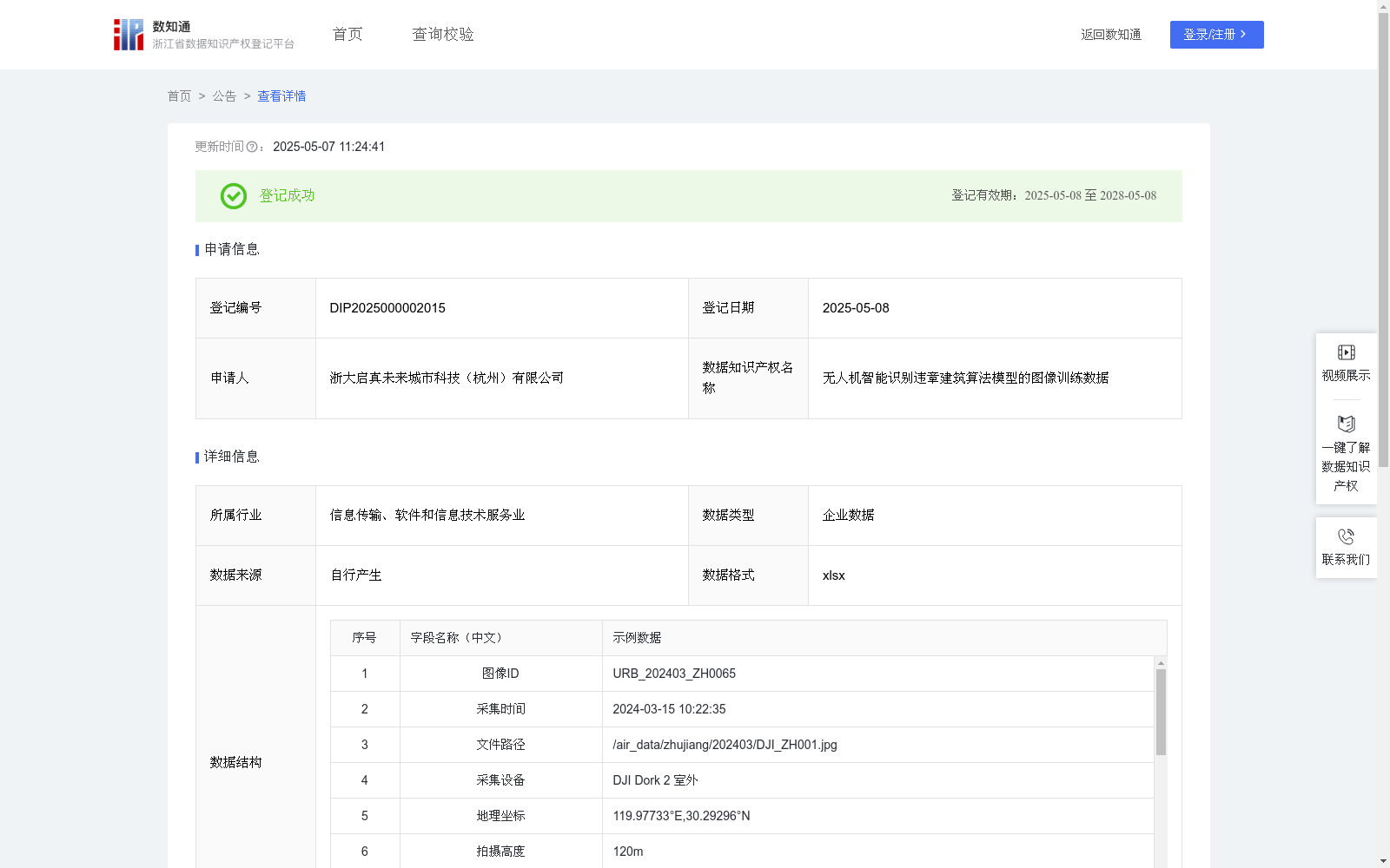
无人机智能识别违章建筑算法模型的图像训练数据
收藏浙江省数据知识产权登记平台2025-05-07 更新2025-05-08 收录
下载链接:
https://www.zjip.org.cn/home/announce/trends/127891
下载链接
链接失效反馈官方服务:
资源简介:
无人机智能识别违章建筑算法模型的图像训练数据的应用场景主要集中在提升AI模型对违章建筑的识别能力和准确度。通过对这些数据的训练,AI模型能够更有效地支撑无人机在国土空间治理中的智能化监测任务,基于地理坐标与二级标注体系,AI模型能区分未批先建/超面积建设/非法改建等违建形态,可应用于山地村落违建排查、工业园区超容建设监测等场景,可应用于支撑相关管理部门对违法建设行为的早发现、精定位、快处置闭环管理需求。1、数据来源:原始数据通过自有智能无人机拍摄采集,记录图像ID、采集时间、文件路径、采集设备、地理坐标、拍摄高度、环境参数、边界框组等数据,通过数据清洗,保证数据质量。
2、数据预处理与标注:①对原始数据按7:2:1比例划分训练集/验证集/测试集;②采用多级标注体系:一级标签(违建/合规)、二级标签(未批先建/超面积建设/非法改建等)。③关联要素包含用地性质、产权范围等信息。
3、模型选择和初始化:采用YOLOv5预训练模型,并初始化模型参数,设置合理的超参数:学习率0.002-0.0001动态调整,批量大小16,锚框参数根据拍摄图像特征优化;同时集成注意力机制增强小目标检测能力。
4、模型训练:使用PyTorch框架实施分布式训练,设置训练时长,采用迁移学习策略,冻结底层特征提取层参数,引入Mosaic数据增强提升复杂场景适应能力,设置早停机制(patience=15)防止过拟合。
5、模型评估:① 构建多维评估体系:基础指标(mAP@0.5)、夜间检测率、误报率、漏报率。② 设置渐进式测试:单体建筑→建筑群→混合功能区→历史保护区四阶段测试。
6、模型优化:优化推理引擎,保障推理速度,并建立区域特征库机制。
The application scenarios of the image training data for the UAV-based intelligent illegal construction recognition algorithm model mainly focus on improving the AI model's recognition capability and accuracy for illegal constructions. Through training with this dataset, the AI model can effectively support the intelligent monitoring tasks of UAVs in land spatial governance. Based on geographic coordinates and the two-level annotation system, the model can distinguish various types of illegal construction forms including construction without prior approval, over-area construction, unlawful reconstruction, etc. It can be applied to scenarios such as illegal construction inspection in mountain villages, over-capacity construction monitoring in industrial parks, and meet the closed-loop management needs of relevant management departments for early detection, precise positioning and rapid disposal of illegal construction behaviors.
1. Data Source: The original data is collected via self-developed intelligent UAVs, recording data items such as image ID, acquisition time, file path, acquisition equipment, geographic coordinates, shooting altitude, environmental parameters and bounding box sets. Data cleaning is conducted to ensure data quality.
2. Data Preprocessing and Annotation: ① Split the original data into training, validation and test sets at a 7:2:1 ratio; ② Adopt a two-level annotation system: first-level labels (illegal/legal), second-level labels (construction without prior approval, over-area construction, unlawful reconstruction, etc.); ③ Associated elements include land use nature, property right scope and other relevant information.
3. Model Selection and Initialization: Adopt the pre-trained YOLOv5 model and initialize its parameters, with reasonable hyperparameters set: learning rate dynamically adjusted between 0.002 and 0.0001, batch size of 16, anchor box parameters optimized based on the characteristics of captured images; meanwhile, integrate the attention mechanism to enhance the detection capability for small targets.
4. Model Training: Implement distributed training using the PyTorch framework, set the training duration, adopt the transfer learning strategy, freeze the parameters of the bottom feature extraction layer, introduce Mosaic data augmentation to improve the adaptability to complex scenarios, and set the early stopping mechanism (patience=15) to prevent overfitting.
5. Model Evaluation: ① Construct a multi-dimensional evaluation system: basic metrics (mAP@0.5), nighttime detection rate, false positive rate and false negative rate; ② Carry out progressive testing in four stages: single building → building cluster → mixed functional zone → historical protection area.
6. Model Optimization: Optimize the inference engine to ensure inference speed, and establish a regional feature database mechanism.
提供机构:
浙大启真未来城市科技(杭州)有限公司
创建时间:
2025-04-07
搜集汇总
数据集介绍
背景与挑战
背景概述
该数据集包含684条无人机拍摄的图像数据,用于训练智能识别违章建筑的算法模型。数据每日更新,具有详细的结构化信息和多级标签,支持多种违建形态的识别,适用于国土空间治理中的智能化监测。
以上内容由遇见数据集搜集并总结生成


