County Distribution Dataset of vascular Plants in Northeast China
收藏DataCite Commons2025-02-02 更新2025-04-16 收录
下载链接:
https://www.scidb.cn/en/detail?dataSetId=50e0731bbbf0497bb7e179470c1dd886
下载链接
链接失效反馈官方服务:
资源简介:
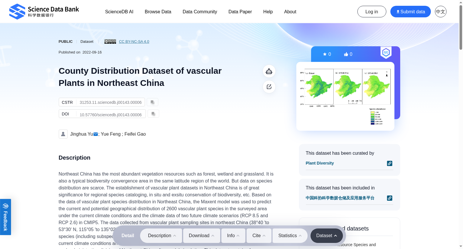
Northeast China has the most abundant vegetation resources such as forest, wetland and grassland. It is also a typical biodiversity convergence area in the same latitude region of the world. But data on species distribution are scarce. The establishment of vascular plant datasets in Northeast China is of great significance for regional species cataloging, in situ and exsitu conservation of biodiversity, etc. Based on the data of vascular plant species distribution in Northeast China, the Maxent model was used to predict the current and potential geographical distribution of 2600 vascular plant species in the surveyed area under the current climate conditions and the climate data of two future climate scenarios (RCP 8.5 and RCP 2.6) in CMIP5. The data collected from vascular plant sampling sites in northeast China (38°40 'to 53°30' N, 115°05 'to 135°02' E) contained 144 076 longitude and latitude records, with a total of 2600 species (including subspecific units). The potential distribution of 2600 vascular plant species under current climate conditions and RCP 2.6 and RCP 8.5 scenarios in 2070 were obtained at county level in each administrative division of Northeast China after model simulation. This dataset contains four subsets, namely: (1) A dataset of the actual distribution of vascular plants in Northeast China, (2) Predicted distribution of vascular plants in Northeast China under current climatic conditions, (3) Potential distribution of vascular plants in Northeast China in 2070 under RCP 2.6 scenario and (4) Potential distribution of vascular plants in Northeast China in 2070 under RCP 8.5 scenario. The data is stored in .csv format. The total amount of data is 11.21 MB. This dataset provides a scientific basis for analyzing the distribution pattern of plant richness in Northeast China under climate change, determining the distribution of priority areas for conservation, and establishing a scientific and advanced construction and management system for protected areas.
中国东北地区拥有最为丰富的森林、湿地与草原等植被资源,同时也是全球同纬度地区典型的生物多样性汇聚区域,但该区域的物种分布数据却较为匮乏。构建东北地区维管植物(vascular plant)数据集,对于区域物种名录编制、生物多样性原位(in situ)与迁地(ex situ)保护等工作具有重要意义。基于东北地区维管植物物种分布数据,本研究采用Maxent模型,在当前气候条件以及CMIP5(Coupled Model Intercomparison Project Phase 5,耦合模式比较计划第五阶段)的两种未来气候情景(RCP 8.5与RCP 2.6,RCP为典型浓度路径Representative Concentration Pathway的缩写)下,预测了研究区内2600种维管植物的当前及潜在地理分布。本次采集的东北地区维管植物样点数据,地理范围介于北纬38°40′至53°30′、东经115°05′至135°02′,共包含144076条经纬度记录,涵盖2600个物种(含种下单元)。经模型模拟后,得到了当前气候条件下,以及2070年RCP 2.6、RCP 8.5情景下东北地区各县级行政区内2600种维管植物的潜在分布数据。本数据集包含四个子数据集,分别为:(1) 东北地区维管植物实际分布数据集;(2) 当前气候条件下东北地区维管植物潜在分布预测数据集;(3) 2070年RCP 2.6情景下东北地区维管植物潜在分布数据集;(4) 2070年RCP 8.5情景下东北地区维管植物潜在分布数据集。所有数据以.csv格式存储,总数据量为11.21 MB。本数据集可为分析气候变化背景下东北地区植物丰富度分布格局、确定保护优先区域、构建科学先进的保护区建设与管理体系提供科学依据。
提供机构:
Science Data Bank
创建时间:
2022-09-16
搜集汇总
数据集介绍
背景与挑战
背景概述
该数据集涵盖了中国东北地区2600种维管植物的实际分布及在RCP 2.6和RCP 8.5两种未来气候情景下的2070年潜在分布预测,数据以.csv格式存储,总大小为11.21 MB。数据集由中国科学院应用生态研究所的研究团队编制,旨在为区域物种编目、生物多样性保护和保护区管理提供科学依据。
以上内容由遇见数据集搜集并总结生成


