欧亚大陆温性草地类型时空变异图—草地类型分类图(2010S)
收藏国家青藏高原科学数据中心2023-06-10 更新2024-03-06 收录
下载链接:
https://data.tpdc.ac.cn/zh-hans/data/26a3ca11-8125-456f-9caf-12aaa50edd3c
下载链接
链接失效反馈官方服务:
资源简介:
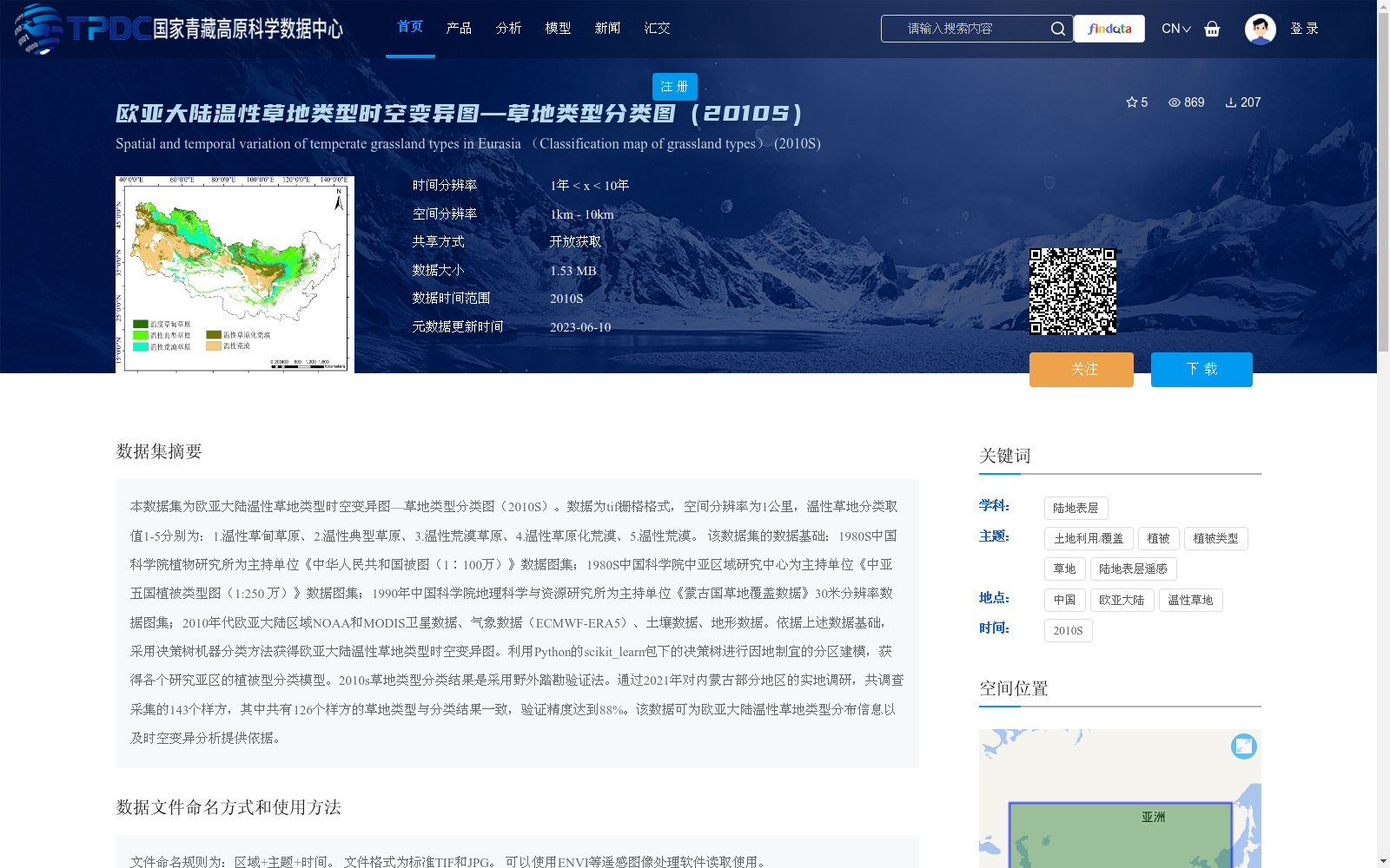
本数据集为欧亚大陆温性草地类型时空变异图—草地类型分类图(2010S)。数据为tif栅格格式,空间分辨率为1公里,温性草地分类取值1-5分别为:1.温性草甸草原、2.温性典型草原、3.温性荒漠草原、4.温性草原化荒漠、5.温性荒漠。 该数据集的数据基础:1980S中国科学院植物研究所为主持单位《中华人民共和国被图(1∶100万)》数据图集;1980S中国科学院中亚区域研究中心为主持单位《中亚五国植被类型图(1:250 万)》数据图集;1990年中国科学院地理科学与资源研究所为主持单位《蒙古国草地覆盖数据》30米分辨率数据图集;2010年代欧亚大陆区域NOAA和MODIS卫星数据、气象数据(ECMWF-ERA5)、土壤数据、地形数据。依据上述数据基础,采用决策树机器分类方法获得欧亚大陆温性草地类型时空变异图。利用Python的scikit_learn包下的决策树进行因地制宜的分区建模,获得各个研究亚区的植被型分类模型。2010s草地类型分类结果是采用野外踏勘验证法。通过2021年对内蒙古部分地区的实地调研,共调查采集的143个样方,其中共有126个样方的草地类型与分类结果一致,验证精度达到88%。该数据可为欧亚大陆温性草地类型分布信息以及时空变异分析提供依据。
This dataset is the spatio-temporal variation map of temperate grassland types in Eurasia — grassland type classification map (2010s). The data is in TIFF raster format with a spatial resolution of 1 km. The classification values 1 to 5 for temperate grasslands correspond to: 1. Temperate meadow steppe, 2. Temperate typical steppe, 3. Temperate desert steppe, 4. Temperate steppe-desert, 5. Temperate desert.
The foundational data sources of this dataset include: 1) The "Vegetation Map of the People's Republic of China (1:1,000,000)" dataset, hosted by the Institute of Botany, Chinese Academy of Sciences (CAS) in the 1980s; 2) The "Vegetation Type Map of the Five Central Asian Countries (1:2,500,000)" dataset, hosted by the Central Asia Research Center, Chinese Academy of Sciences in the 1980s; 3) The 30-meter resolution Mongolian grass cover dataset, hosted by the Institute of Geographic Sciences and Natural Resources Research, CAS in 1990; 4) Regional NOAA and MODIS satellite data, meteorological data (ECMWF-ERA5), soil data and topographic data across Eurasia in the 2010s.
Based on the above data foundations, the spatio-temporal variation map of temperate grassland types in Eurasia was generated using decision tree machine classification. Decision tree models from the Python scikit-learn package were utilized to conduct site-specific regionalized modeling, yielding vegetation type classification models for each research sub-region.
The 2010s grassland type classification results were validated via field reconnaissance surveys. In 2021, field investigations were conducted in parts of Inner Mongolia, with a total of 143 quadrats sampled. Among these, 126 quadrats matched the classification results, achieving a validation accuracy of 88%. This dataset can provide a reliable basis for analyzing the distribution information and spatio-temporal variation patterns of temperate grassland types in Eurasia.
提供机构:
唐家奎,徐雪峰,张安安,张娜
创建时间:
2023-05-24
搜集汇总
数据集介绍
背景与挑战
背景概述
本数据集是欧亚大陆温性草地类型分类图(2010S),以1公里空间分辨率的TIF栅格格式呈现,将温性草地划分为5种类型(如温性草甸草原、温性典型草原等)。它基于多源历史植被数据和2010年代遥感、气象等信息,采用决策树机器学习方法生成,并通过实地验证达到88%的精度,适用于草地分布和时空变异分析。
以上内容由遇见数据集搜集并总结生成


