东昆仑-祁漫塔格铁铅锌铜矿集区地质矿产数据集(2021.11-2024.10)
收藏国家青藏高原科学数据中心2025-04-21 更新2025-07-12 收录
下载链接:
https://data.tpdc.ac.cn/zh-hans/data/468e2c41-2f95-468c-8d21-51a56babb0ef
下载链接
链接失效反馈官方服务:
资源简介:
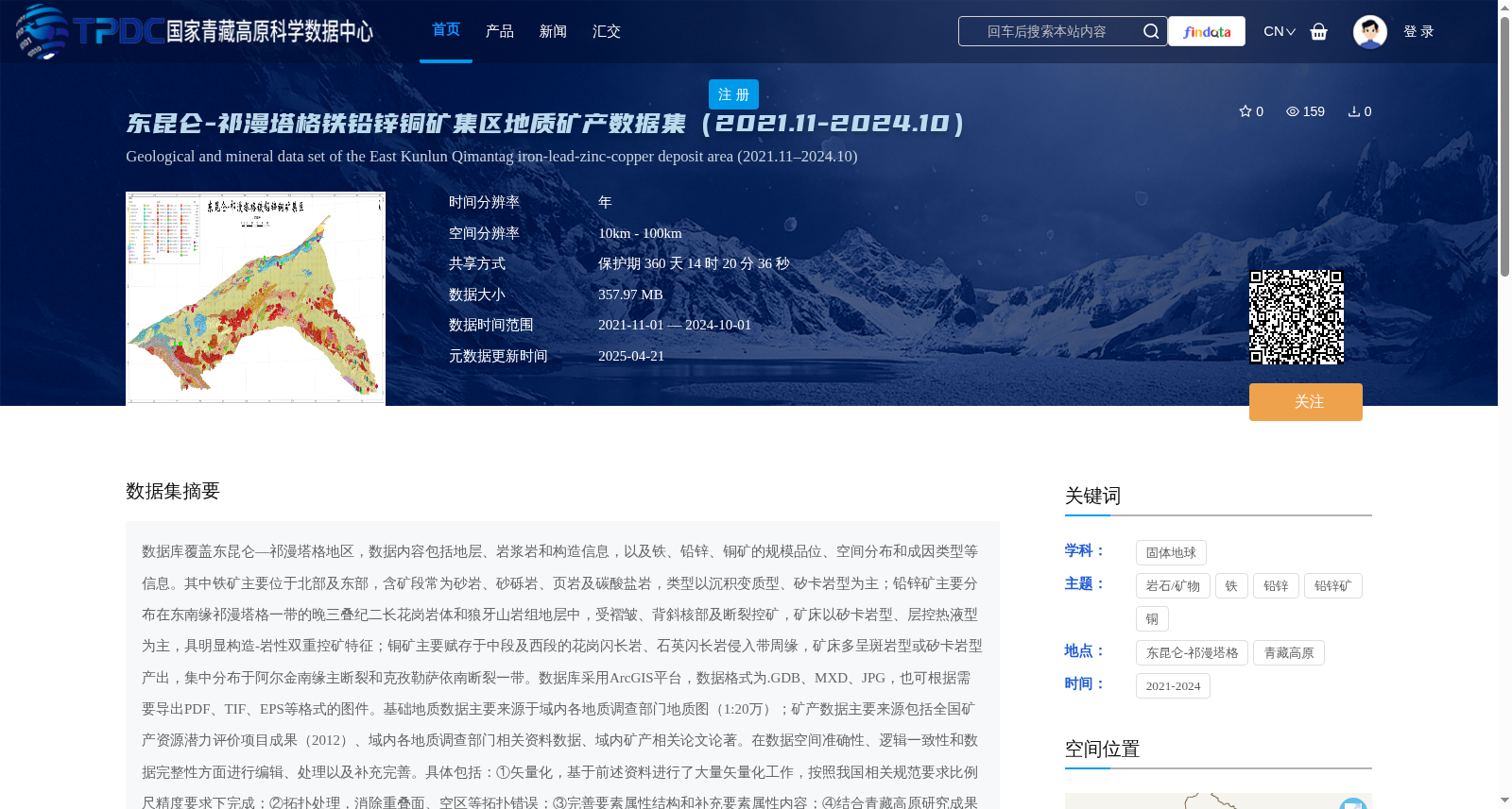
数据库覆盖东昆仑—祁漫塔格地区,数据内容包括地层、岩浆岩和构造信息,以及铁、铅锌、铜矿的规模品位、空间分布和成因类型等信息。其中铁矿主要位于北部及东部,含矿段常为砂岩、砂砾岩、页岩及碳酸盐岩,类型以沉积变质型、矽卡岩型为主;铅锌矿主要分布在东南缘祁漫塔格一带的晚三叠纪二长花岗岩体和狼牙山岩组地层中,受褶皱、背斜核部及断裂控矿,矿床以矽卡岩型、层控热液型为主,具明显构造-岩性双重控矿特征;铜矿主要赋存于中段及西段的花岗闪长岩、石英闪长岩侵入带周缘,矿床多呈斑岩型或矽卡岩型产出,集中分布于阿尔金南缘主断裂和克孜勒萨依南断裂一带。数据库采用ArcGIS平台,数据格式为.GDB、MXD、JPG,也可根据需要导出PDF、TIF、EPS等格式的图件。基础地质数据主要来源于域内各地质调查部门地质图(1:20万);矿产数据主要来源包括全国矿产资源潜力评价项目成果(2012)、域内各地质调查部门相关资料数据、域内矿产相关论文论著。在数据空间准确性、逻辑一致性和数据完整性方面进行编辑、处理以及补充完善。具体包括:①矢量化,基于前述资料进行了大量矢量化工作,按照我国相关规范要求比例尺精度要求下完成;②拓扑处理,消除重叠面、空区等拓扑错误;③完善要素属性结构和补充要素属性内容;④结合青藏高原研究成果和认识,对数据内容进行了持续修改和完善。主要服务于1:25万地质矿产图,以及岩性、地质年代、地层分区等信息交互提取、分析及专题图件编制。
The database covers the East Kunlun-Qimantag region. Its data content includes stratigraphic, magmatic rock, and structural information, as well as information such as the scale, grade, spatial distribution, and genetic types of iron, lead-zinc, and copper deposits. Among them, iron deposits are mainly located in the northern and eastern parts; their ore-bearing horizons are mostly sandstone, glutenite, shale, and carbonate rocks, and the main deposit types are sedimentary metamorphic and skarn types. Lead-zinc deposits are mainly distributed in the Late Triassic monzonitic granite bodies and Langyashan Formation strata in the Qimantag area of the southeastern margin. They are controlled by folds, anticline cores and faults, with the main deposit types being skarn and strata-bound hydrothermal types, showing obvious dual ore-controlling characteristics of structure and lithology. Copper deposits are mainly hosted in the periphery of granodiorite and quartz diorite intrusion zones in the middle and western sections. Most deposits occur as porphyry or skarn types, and are concentrated in the areas of the main southern Altyn Tagh fault and the southern Kezilesayi fault. The database is built on the ArcGIS platform, with data formats including .GDB, .MXD and .JPG. Map files in formats such as PDF, TIF and EPS can also be exported as needed. Basic geological data mainly comes from 1:200000 geological maps from various regional geological survey departments; mineral data sources mainly include the results of the National Mineral Resource Potential Evaluation Project (2012), relevant data from various regional geological survey departments, and papers and monographs related to regional minerals. Edits, processing and supplementary improvements have been carried out to ensure spatial accuracy, logical consistency and data integrity of the data. The specific work includes: ① Vectorization: A large amount of vectorization work has been completed based on the aforementioned data, meeting the scale accuracy requirements specified by relevant Chinese standards; ② Topological processing: Eliminating topological errors such as overlapping polygons and empty areas; ③ Improving feature attribute structures and supplementing feature attribute contents; ④ Continuously modifying and improving the data content based on research results and understandings of the Qinghai-Tibet Plateau. It is mainly used for compiling 1:250000 geological and mineral maps, as well as for interactive extraction, analysis and thematic map compilation of information such as lithology, geological age and stratigraphic division.
提供机构:
刘琰
创建时间:
2025-04-05
搜集汇总
数据集介绍
背景与挑战
背景概述
该数据集覆盖东昆仑-祁漫塔格地区,提供2021年至2024年的地质矿产信息,包括地层、岩浆岩、构造以及铁、铅锌、铜矿的分布、规模和成因类型,数据经过专业编辑处理,适用于地质矿产图编制和专题分析。数据集以ArcGIS格式为主,来源于权威地质调查和科研项目,服务于区域矿产资源研究和勘探工作。
以上内容由遇见数据集搜集并总结生成


