积雪物理过程模型支持的全球AMSR2被动微波雪深反演数据集(2013-2020)
收藏国家青藏高原科学数据中心2023-02-02 更新2024-03-01 收录
下载链接:
https://data.tpdc.ac.cn/zh-hans/data/c3b7d80c-a43b-4b0b-a09e-a38f837fb921
下载链接
链接失效反馈官方服务:
资源简介:
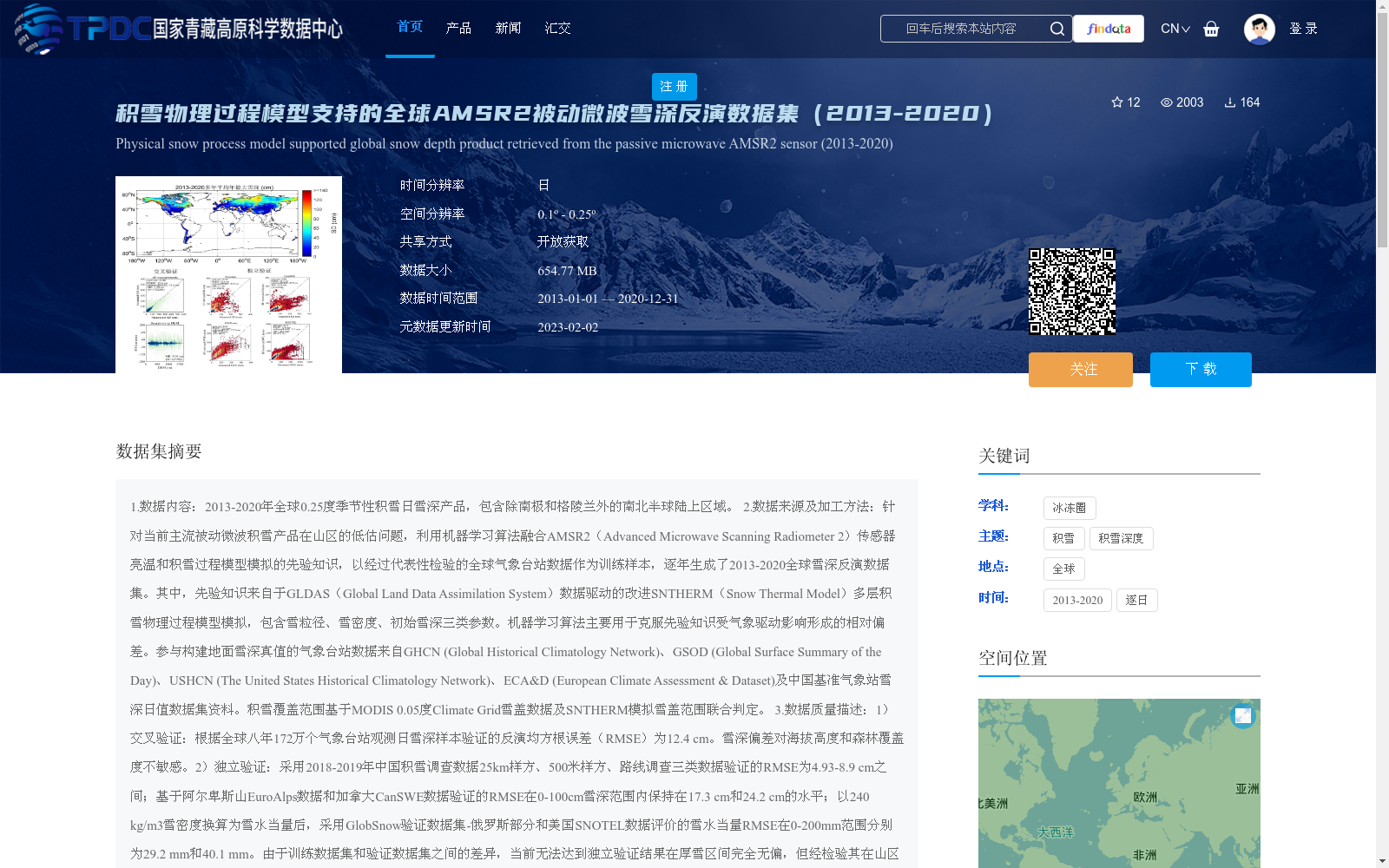
1.数据内容:2013-2020年全球0.25度季节性积雪日雪深产品,包含除南极和格陵兰外的南北半球陆上区域。
2.数据来源及加工方法:针对当前主流被动微波积雪产品在山区的低估问题,利用机器学习算法融合AMSR2(Advanced Microwave Scanning Radiometer 2)传感器亮温和积雪过程模型模拟的先验知识,以经过代表性检验的全球气象台站数据作为训练样本,逐年生成了2013-2020全球雪深反演数据集。其中,先验知识来自于GLDAS(Global Land Data Assimilation System)数据驱动的改进SNTHERM(Snow Thermal Model)多层积雪物理过程模型模拟,包含雪粒径、雪密度、初始雪深三类参数。机器学习算法主要用于克服先验知识受气象驱动影响形成的相对偏差。参与构建地面雪深真值的气象台站数据来自GHCN (Global Historical Climatology Network)、GSOD (Global Surface Summary of the Day)、USHCN (The United States Historical Climatology Network)、ECA&D (European Climate Assessment & Dataset)及中国基准气象站雪深日值数据集资料。积雪覆盖范围基于MODIS 0.05度Climate Grid雪盖数据及SNTHERM模拟雪盖范围联合判定。
3.数据质量描述:1)交叉验证:根据全球八年172万个气象台站观测日雪深样本验证的反演均方根误差(RMSE)为12.4 cm。雪深偏差对海拔高度和森林覆盖度不敏感。2)独立验证:采用2018-2019年中国积雪调查数据25km样方、500米样方、路线调查三类数据验证的RMSE为4.93-8.9 cm之间;基于阿尔卑斯山EuroAlps数据和加拿大CanSWE数据验证的RMSE在0-100cm雪深范围内保持在17.3 cm和24.2 cm的水平;以240 kg/m3雪密度换算为雪水当量后,采用GlobSnow验证数据集-俄罗斯部分和美国SNOTEL数据评价的雪水当量RMSE在0-200mm范围分别为29.2 mm和40.1 mm。由于训练数据集和验证数据集之间的差异,当前无法达到独立验证结果在厚雪区间完全无偏,但经检验其在山区或山区边缘的表现优于AMSR2官方产品和GlobSnow产品。注意:当前验证结果基于有代表性的观测数据,代表性评价标准请参看论文。
4.数据应用成果及前景:积雪时空分布研究;为冰冻圈其它要素研究提供雪深参考信息;当前阶段需求偏差更小的山区粗分辨率雪深产品的研究者。
5.其它:我们对研究所用各类原始数据的提供者表示感谢,请参考论文获取致谢及原始数据相关信息。
1. Data Content: Global 0.25° seasonal daily snow depth product from 2013 to 2020, covering terrestrial areas of the Northern and Southern Hemispheres except Antarctica and Greenland.
2. Data Sources and Processing Methods: To address the underestimation issue of mainstream passive microwave snow products in mountainous areas, we adopted machine learning algorithms to fuse the brightness temperature data from the AMSR2 (Advanced Microwave Scanning Radiometer 2) sensor and the prior knowledge simulated by the snow process model, using the globally representative-validated meteorological station data as training samples, and generated the global snow depth inversion dataset for 2013-2020 on an annual basis. Specifically, the prior knowledge was derived from simulations of the improved multi-layer snow physical process model SNTHERM (Snow Thermal Model) driven by GLDAS (Global Land Data Assimilation System) data, including three types of parameters: snow grain size, snow density, and initial snow depth. The machine learning algorithms were primarily used to correct the relative biases caused by meteorological driving effects in the prior knowledge. The meteorological station data used to construct the ground-truth snow depth were sourced from GHCN (Global Historical Climatology Network), GSOD (Global Surface Summary of the Day), USHCN (The United States Historical Climatology Network), ECA&D (European Climate Assessment & Dataset), and the daily snow depth dataset of China's national reference meteorological stations. Snow cover extent was jointly determined based on the MODIS 0.05° Climate Grid snow cover data and the snow cover extent simulated by SNTHERM.
3. Data Quality Description: 1) Cross-validation: The inversion root mean square error (RMSE) verified using 1.72 million daily snow depth samples from global meteorological stations over 8 years was 12.4 cm. The snow depth bias is insensitive to elevation and forest cover. 2) Independent validation: The RMSE verified using three types of China's snow survey data (25 km quadrat, 500 m quadrat, and route survey) from 2018 to 2019 ranged from 4.93 to 8.9 cm. The RMSE verified using EuroAlps data from the Alps and CanSWE data from Canada remained at 17.3 cm and 24.2 cm respectively within the snow depth range of 0-100 cm. After converting to snow water equivalent (SWE) using a snow density of 240 kg/m³, the RMSE of SWE evaluated using the Russian portion of the GlobSnow validation dataset and US SNOTEL data was 29.2 mm and 40.1 mm respectively within the 0-200 mm range. Due to the differences between the training and validation datasets, it is currently impossible to achieve completely unbiased independent validation results in the thick snow interval. However, tests have shown that its performance in mountainous areas or mountain margins is better than that of the official AMSR2 product and the GlobSnow product. Note: The current validation results are based on representative observational data; please refer to the paper for the representative evaluation criteria.
4. Data Application Achievements and Prospects: Research on the spatiotemporal distribution of snow; Providing reference snow depth information for studies on other components of the cryosphere; Serving researchers who require mountainous coarse-resolution snow depth products with smaller biases at the current stage.
5. Others: We would like to express our gratitude to the providers of all types of raw data used in this study. Please refer to the paper for acknowledgments and relevant information about the raw data.
提供机构:
潘金梅,杨建卫,蒋玲梅,熊川,潘方博,施建成,高晓文
创建时间:
2022-11-24
搜集汇总
数据集介绍
背景与挑战
背景概述
该数据集提供了2013-2020年全球0.25度季节性积雪日雪深产品,覆盖除南极和格陵兰外的南北半球陆上区域。通过融合AMSR2传感器亮温和积雪物理过程模型模拟的先验知识,结合全球气象台站数据作为训练样本,优化了山区雪深反演的准确性,其均方根误差(RMSE)在不同验证条件下表现优于同类产品。
以上内容由遇见数据集搜集并总结生成


