青藏高原土壤冻融深度数据集(2011-2020)
收藏国家青藏高原科学数据中心2025-05-13 更新2025-06-07 收录
下载链接:
https://data.tpdc.ac.cn/zh-hans/data/d9b7445c-caac-4504-a003-cacfab2299f8
下载链接
链接失效反馈官方服务:
资源简介:
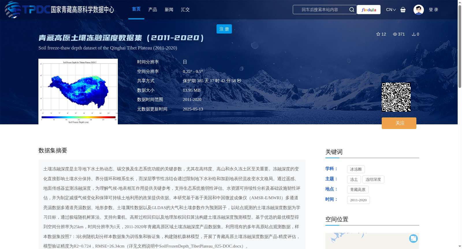
土壤冻融深度是主导地下水土热动态、碳交换及生态系统功能的关键参数,尤其在高纬度、高山和永久冻土区至关重要。冻融深度的变化直接影响土壤水分保持、养分循环和根系生长,而深层季节性冻结会通过限制地下水补给和加剧地表径流改变水文格局。通过遥感、地面传感器监测冻融深度,为理解气候-地表相互作用提供关键参考,支持生态系统脆弱性评估、水资源可持续性分析及基础设施韧性评估,并为制定减缓气候变化和保障可持续土地利用的政策提供依据。本研究基于基于美国和中国微波成像仪(AMSR-E/MWRI)多通道亮温数据多通道亮温数据、地形参数、土壤属性数据以及GLDAS的大气和土壤参数作为预测因子,以站点观测的土壤冻融深度数据为学习目标,通过极端随机树算法、支持向量机、高斯过程回归以及地理加权回归算法构建土壤冻融深度预测模型。基于优选的最优模型得到空间分辨率为25km,时间分辨率为1天,2011-2020年青藏高原区域土壤冻融深度产品数据集。利用现有的多年高原站点观测数据,样本数据集按照7:3比例随机划分样本数据集为训练集和验证集,构建随机森林模型,开展了青藏高原土壤冻融深度数据产品-精度评估,模型验证精度为R2=0.724,RMSE=26.34cm(详见文档说明中SoilFrozenDepth_TibetPlateau_025-DOC.docx)。
Soil freeze-thaw depth is a key parameter governing subsurface hydrothermal dynamics, carbon exchange, and ecosystem functions, and is particularly critical in high-latitude, alpine, and permafrost regions. Changes in freeze-thaw depth directly affect soil water retention, nutrient cycling, and root growth, while deep seasonal freezing alters hydrological regimes by restricting groundwater recharge and exacerbating surface runoff. Monitoring freeze-thaw depth via remote sensing and ground-based sensors provides critical references for understanding climate-surface interactions, supports assessments of ecosystem vulnerability, water resource sustainability, and infrastructure resilience, and offers a basis for formulating policies to mitigate climate change and ensure sustainable land use.
This study used multi-channel brightness temperature data from the American and Chinese microwave imagers (AMSR-E/MWRI), topographic parameters, soil property data, and atmospheric and soil parameters from GLDAS as predictors, with in-situ observed soil freeze-thaw depth data as the learning target, to construct soil freeze-thaw depth prediction models using Extremely Randomized Trees algorithm, Support Vector Machine, Gaussian Process Regression, and Geographically Weighted Regression algorithms. Based on the optimized best-performing model, a soil freeze-thaw depth product dataset for the Tibetan Plateau was generated, with a spatial resolution of 25 km, temporal resolution of 1 day, covering the period 2011–2020.
Using existing long-term in-situ observed data from the plateau, the sample dataset was randomly divided into training and validation sets at a 7:3 ratio. A Random Forest model was constructed to conduct accuracy assessment of the Tibetan Plateau soil freeze-thaw depth data product, with model validation accuracy of R²=0.724 and RMSE=26.34 cm (see SoilFrozenDepth_TibetPlateau_025-DOC.docx in the document description for details).
提供机构:
胡皓
创建时间:
2025-03-24
搜集汇总
数据集介绍
背景与挑战
背景概述
该数据集提供了2011-2020年青藏高原区域土壤冻融深度的日值数据,空间分辨率为0.25° - 0.5°,基于多源数据和多种算法构建,模型验证精度较高(R2=0.724)。数据以NetCDF格式存储,适用于研究土壤冻融深度对气候、水文和生态系统的影响。
以上内容由遇见数据集搜集并总结生成


