BU-3DFE (Binghamton University 3D Facial Expression)|面部表情识别数据集|3D数据数据集
收藏www.cs.binghamton.edu2024-11-01 收录
下载链接:
http://www.cs.binghamton.edu/~lijun/Research/3DFE/3DFE_Analysis.html
下载链接
链接失效反馈资源简介:
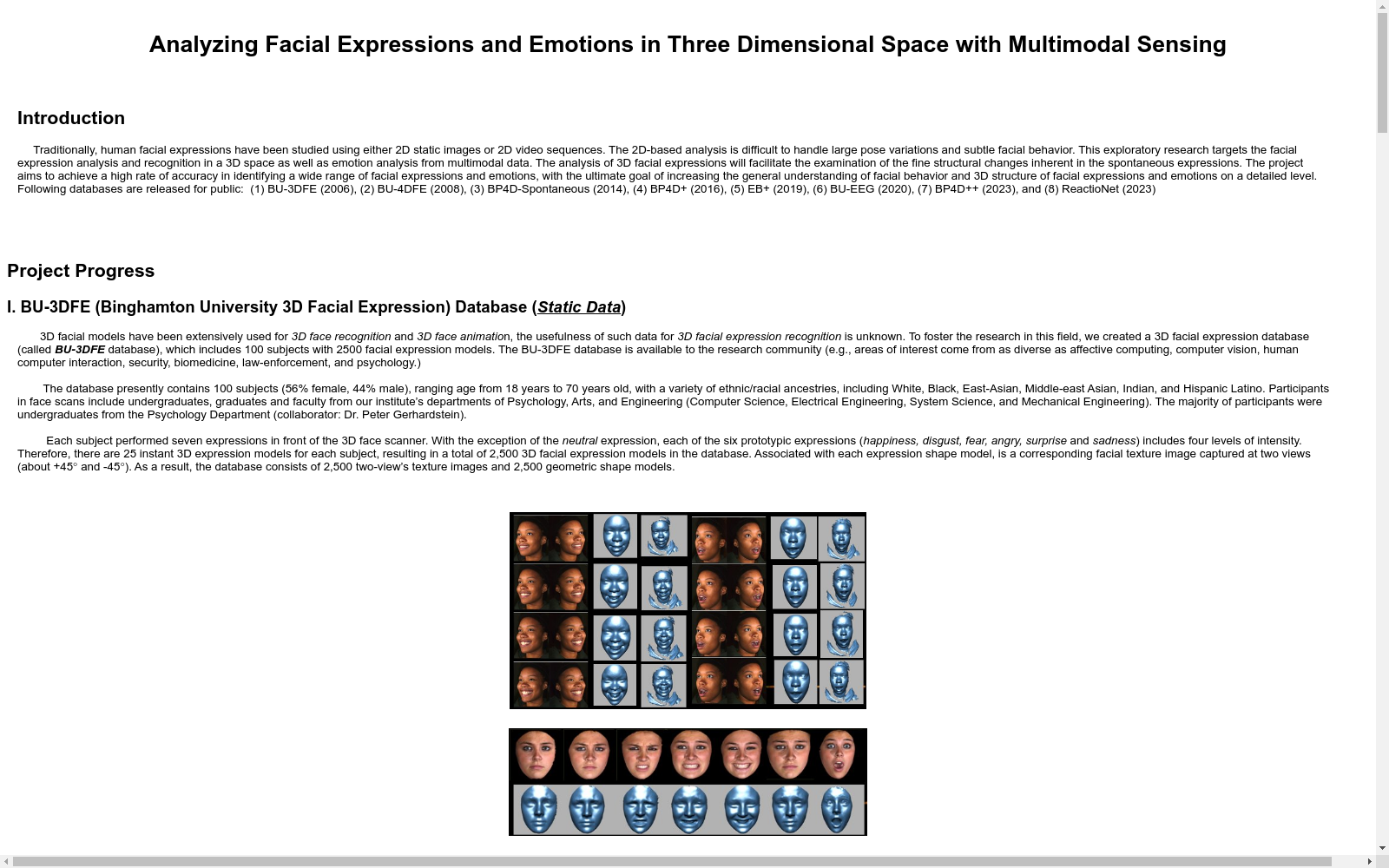
BU-3DFE数据集包含100名志愿者的3D面部表情数据,每个志愿者展示了6种基本情绪(愤怒、厌恶、恐惧、快乐、悲伤、惊讶)和一种中性表情。数据集包括每个表情的3D面部模型和相应的2D图像。
提供机构:
www.cs.binghamton.edu
AI搜集汇总
数据集介绍
构建方式
BU-3DFE数据集由Binghamton大学精心构建,旨在提供一个全面的三维面部表情数据库。该数据集通过高精度的三维扫描技术,捕捉了100名不同性别和种族的成年人的面部表情。每个参与者被要求展示六种基本情绪(愤怒、厌恶、恐惧、快乐、悲伤和惊讶)以及中性表情,每种表情在不同强度下被记录。此外,数据集还包括了光照条件和头部姿态的变化,以模拟真实世界的多样性。
使用方法
BU-3DFE数据集适用于多种计算机视觉和人工智能研究领域,如面部表情识别、情感计算和人机交互。研究人员可以通过该数据集训练和验证算法,以提高对复杂面部表情的理解和分类能力。此外,数据集的多维度特性也使其成为开发和测试光照不变性和姿态鲁棒性算法的理想选择。使用者可以通过访问Binghamton大学的官方网站获取数据集,并遵循其使用许可协议进行研究和开发。
背景与挑战
背景概述
BU-3DFE(Binghamton University 3D Facial Expression)数据集由Binghamton大学的研究人员于2006年创建,专注于三维面部表情分析。该数据集包含了100名志愿者的三维面部扫描数据,涵盖了六种基本情绪(愤怒、厌恶、恐惧、快乐、悲伤、惊讶)以及中性表情。每个表情均在不同强度下进行记录,共计2500个三维面部模型。BU-3DFE数据集的推出,极大地推动了计算机视觉和情感计算领域的发展,为研究人员提供了丰富的数据资源,促进了面部表情识别技术的进步。
当前挑战
尽管BU-3DFE数据集在三维面部表情分析领域具有重要地位,但其构建和应用过程中仍面临诸多挑战。首先,数据集的多样性受限于样本数量和种族背景,可能导致模型在不同人群中的泛化能力不足。其次,三维面部数据的获取和处理技术复杂,需要高精度的扫描设备和复杂的算法支持,增加了数据处理的难度和成本。此外,面部表情识别在实际应用中还需应对光照变化、头部姿态变化等环境因素的影响,这些都为模型的鲁棒性和准确性提出了更高的要求。
发展历史
创建时间与更新
BU-3DFE数据集由美国宾厄姆顿大学于2006年创建,旨在为3D面部表情分析提供标准化的数据资源。该数据集自创建以来未有公开的更新记录。
重要里程碑
BU-3DFE数据集的发布标志着3D面部表情研究领域的一个重要里程碑。它首次提供了包含600个3D面部模型的数据集,涵盖了250名不同性别和种族的参与者,每个模型展示了6种基本表情和3种强度级别。这一数据集极大地推动了3D面部表情识别和分析技术的发展,为后续研究提供了坚实的基础。
当前发展情况
尽管BU-3DFE数据集自创建以来未有更新,但其对3D面部表情研究领域的贡献依然显著。该数据集被广泛应用于计算机视觉、模式识别和人工智能等多个领域,为研究人员提供了丰富的实验数据和基准测试资源。随着深度学习和大数据技术的进步,BU-3DFE数据集的影响力持续扩大,成为3D面部表情分析领域不可或缺的经典数据集之一。
发展历程
- BU-3DFE数据集首次发表,由Binghamton大学的研究团队创建,旨在提供一个标准化的3D面部表情数据库,用于研究和开发面部表情识别算法。
- BU-3DFE数据集首次应用于学术研究,特别是在计算机视觉和模式识别领域,为研究人员提供了一个重要的基准数据集。
- 随着深度学习技术的发展,BU-3DFE数据集被广泛用于训练和验证深度学习模型,特别是在面部表情识别任务中。
- BU-3DFE数据集的扩展版本发布,增加了更多的样本和表情类别,进一步丰富了数据集的内容和多样性。
- BU-3DFE数据集被多个国际会议和期刊引用,成为面部表情分析领域的重要参考数据集之一。
- BU-3DFE数据集的应用范围进一步扩大,不仅在学术研究中继续发挥重要作用,还在商业应用中得到了实际应用,如情感计算和人机交互领域。
常用场景
经典使用场景
在计算机视觉领域,BU-3DFE数据集以其丰富的三维面部表情模型而著称。该数据集包含了100名不同性别和种族的参与者,每个参与者在不同情绪状态下(如愤怒、恐惧、快乐等)的面部三维扫描数据。这些数据为研究人员提供了宝贵的资源,用于开发和验证基于三维面部表情识别的算法。通过分析这些三维模型,研究者能够深入理解面部表情与情绪状态之间的复杂关系,从而推动情感计算和人脸识别技术的发展。
解决学术问题
BU-3DFE数据集在解决面部表情识别中的多变性和复杂性问题方面具有重要意义。传统的二维图像数据集在处理光照、姿态和遮挡等问题时存在局限性,而三维数据能够提供更为全面和准确的面部信息。该数据集帮助研究者克服了这些挑战,推动了情感计算和人脸识别领域的进步。通过利用BU-3DFE数据集,研究者能够开发出更为鲁棒和精确的面部表情识别算法,这对于理解人类情感和行为具有深远的学术价值。
实际应用
BU-3DFE数据集在实际应用中展现出广泛的前景。例如,在人机交互领域,基于该数据集开发的面部表情识别系统可以用于情感辅助技术,帮助自闭症儿童理解和表达情感。此外,在安全监控和法医鉴定中,该数据集支持的面部表情分析技术能够提高识别和判断的准确性。医疗领域也可受益于该数据集,通过分析患者的面部表情变化,辅助诊断和治疗心理健康问题。这些应用不仅提升了技术的实用性,还为多个行业带来了创新解决方案。
数据集最近研究
最新研究方向
在人脸表情分析领域,BU-3DFE数据集因其丰富的三维表情样本而备受关注。最新研究方向主要集中在利用深度学习和三维几何特征,提升表情识别的准确性和鲁棒性。相关研究不仅探索了如何从三维数据中提取更具判别力的特征,还致力于解决光照变化、姿态差异等实际应用中的挑战。此外,该数据集还被广泛应用于情感计算和虚拟现实交互中,推动了人机交互技术的进步。这些前沿研究不仅提升了表情识别的精度,也为情感智能的发展提供了坚实的基础。
相关研究论文
- 1BU-3DFE (Binghamton University 3D Facial Expression Database): A 3D Facial Expression Database for Biometric ApplicationsBinghamton University · 2006年
- 23D Facial Expression Recognition Using a Dynamic Texture-Based MethodUniversity of Oulu · 2010年
- 3A Comprehensive Study on 3D Facial Expression RecognitionUniversity of Trento · 2015年
- 4Deep Learning for 3D Facial Expression Recognition: A SurveyUniversity of Surrey · 2020年
- 53D Facial Expression Recognition Using Convolutional Neural NetworksUniversity of California, Irvine · 2018年
以上内容由AI搜集并总结生成


