青藏高原冈底斯西段革吉镇南矿区成矿要素图
收藏国家青藏高原科学数据中心2025-06-16 更新2025-07-12 收录
下载链接:
https://data.tpdc.ac.cn/zh-hans/data/54c697b7-eef8-4bc1-9938-82684fd88bd0
下载链接
链接失效反馈官方服务:
资源简介:
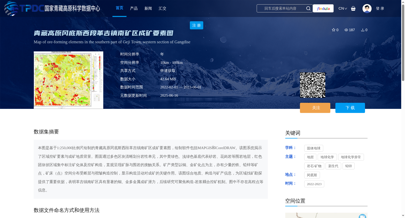
本图是基于1:250,000比例尺绘制的青藏高原冈底斯西段革吉镇南矿区成矿要素图,绘制软件包括MAPGIS和CorelDRAW。该图系统揭示了区域控矿要素与成矿地质背景。图面通过多色区块清晰划分岩性单元,其中黄绿色、浅绿色基底代表砂岩、花岗岩等围岩地层,红色团块状区域集中标注矿化体及控矿构造,直观呈现矿脉与围岩的接触关系。矿产类型以铜、金矿化点为主,亦有少量的铁、铅锌等矿点,矿床(点)空间分布受断层与褶皱构造控制,显示构造活动对成矿的关键作用。该图综合地质、构造与矿产信息,为区域找矿勘探提供了重要依据,表明革吉镇南矿区具有显著的铜、金多金属成矿潜力,后续研究可聚焦构造-岩浆耦合控矿机制。图中不存在高程点等信息。
This map is a metallogenic element map of the southern mining area of Geji Town, western segment of the Gangdise Mountains, Qinghai-Tibet Plateau, compiled at a scale of 1:250,000 using MAPGIS and CorelDRAW. It systematically reveals regional ore-controlling factors and the geological background of mineralization. The map clearly divides lithological units via multicolored blocks: the yellow-green and light green bases represent surrounding rock strata such as sandstone and granite, while the red massive areas are marked with mineralized bodies and ore-controlling structures, intuitively displaying the contact relationship between ore veins and surrounding rocks. The main mineral types are copper and gold mineralization occurrences, with a small number of iron, lead-zinc and other mineral occurrences. The spatial distribution of deposits (occurrences) is controlled by faults and fold structures, demonstrating the critical role of tectonic activity in mineralization. This map integrates geological, structural and mineral resources information, providing an important basis for regional mineral prospecting and exploration, indicating that the southern mining area of Geji Town has significant Cu-Au polymetallic mineralization potential. Future research can focus on the ore-controlling mechanism of tectonic-magmatic coupling. No elevation point or other similar information is included in this map.
提供机构:
杨竹森
创建时间:
2025-05-30
搜集汇总
数据集介绍
背景与挑战
背景概述
该数据集为青藏高原冈底斯西段革吉镇南矿区的成矿要素图,基于1:250,000比例尺绘制,使用MAPGIS和CorelDRAW软件。它系统揭示了区域控矿要素与成矿地质背景,以铜、金矿化点为主,显示矿产分布受断层与褶皱构造控制,为区域找矿勘探提供重要依据,表明该区具有显著的铜、金多金属成矿潜力。数据时间范围为2022年2月至2023年6月,空间分辨率为10km-100km,数据大小为42.64 MB。
以上内容由遇见数据集搜集并总结生成


