喀喇昆仑中部区域冰流场数据集(V1.0)(1999-2003)
收藏地球大数据科学工程2024-03-04 收录
下载链接:
https://data.casearth.cn/sdo/detail/65432beb819aec3beb1bbf7a
下载链接
链接失效反馈官方服务:
资源简介:
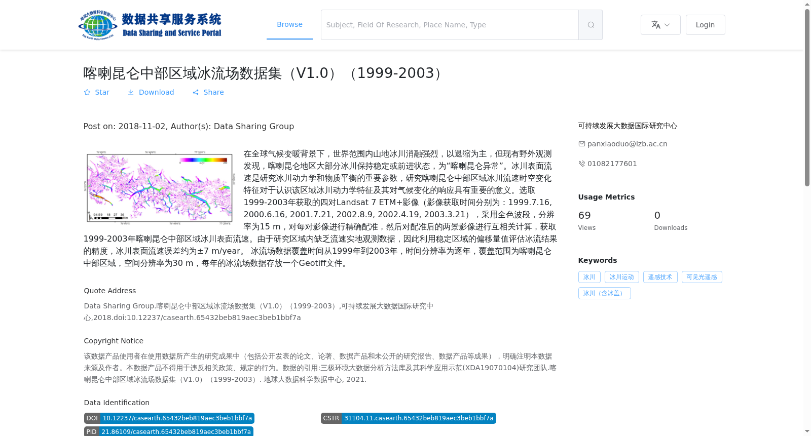
在全球气候变暖背景下,世界范围内山地冰川消融强烈,以退缩为主,但现有野外观测发现,喀喇昆仑地区大部分冰川保持稳定或前进状态,为“喀喇昆仑异常”。冰川表面流速是研究冰川动力学和物质平衡的重要参数,研究喀喇昆仑中部区域冰川流速时空变化特征对于认识该区域冰川动力学特征及其对气候变化的响应具有重要的意义。选取1999-2003年获取的四对Landsat 7 ETM+影像(影像获取时间分别为:1999.7.16, 2000.6.16, 2001.7.21, 2002.8.9, 2002.4.19, 2003.3.21),采用全色波段,分辨率为15 m,对每对影像进行精确配准,然后对配准后的两景影像进行互相关计算,获取1999-2003年喀喇昆仑中部区域冰川表面流速。由于研究区域内缺乏流速实地观测数据,因此利用稳定区域的偏移量值评估冰流结果的精度,冰川表面流速误差约为±7 m/year。
冰流场数据覆盖时间从1999年到2003年,时间分辨率为逐年,覆盖范围为喀喇昆仑中部区域,空间分辨率为30 m,每年的冰流场数据存放一个Geotiff文件。
Against the backdrop of global warming, mountain glaciers worldwide undergo intense ablation and mostly retreat. However, existing field observations have found that most glaciers in the Karakoram region remain stable or even advance, which is known as the "Karakoram Anomaly". Glacier surface velocity is a critical parameter for studying glacier dynamics and mass balance. Investigating the spatiotemporal variation characteristics of glacier velocity in the central Karakoram region is of great significance for understanding the glacier dynamics in this area and their response to climate change.
We selected four pairs of Landsat 7 ETM+ images acquired between 1999 and 2003 (the acquisition dates are: 1999.7.16, 2000.6.16, 2001.7.21, 2002.8.9, 2002.4.19, 2003.3.21). The panchromatic band with a spatial resolution of 15 m was used. For each pair of images, accurate co-registration was performed first, then cross-correlation calculation was conducted on the two co-registered image scenes to obtain the glacier surface velocity in the central Karakoram region from 1999 to 2003.
Given the lack of in-situ velocity observation data in the study area, the offset values in stable regions were used to assess the accuracy of the ice flow results, with the glacier surface velocity error being approximately ±7 m/year.
The ice flow field data covers the period from 1999 to 2003, with an annual temporal resolution. The coverage spans the central Karakoram region, with a spatial resolution of 30 m. Each year's ice flow field data is stored as a single GeoTIFF file.
提供机构:
可持续发展大数据国际研究中心
搜集汇总
数据集介绍
背景与挑战
背景概述
该数据集提供了1999年至2003年喀喇昆仑中部区域冰川表面流速的逐年观测数据,基于Landsat 7 ETM+影像通过互相关计算生成,空间分辨率为30米,以GeoTiff格式存储。数据集旨在研究'喀喇昆仑异常'现象,帮助理解冰川动力学及其对气候变化的响应,流速误差约为±7米/年,适用于冰川运动和遥感技术相关分析。
以上内容由遇见数据集搜集并总结生成


