中国1:1000万冻土区划及类型图(2000)
收藏国家青藏高原科学数据中心2021-04-20 更新2024-03-01 收录
下载链接:
https://data.tpdc.ac.cn/zh-hans/data/15bf484c-e4bc-4990-b01b-c26da686e254
下载链接
链接失效反馈官方服务:
资源简介:
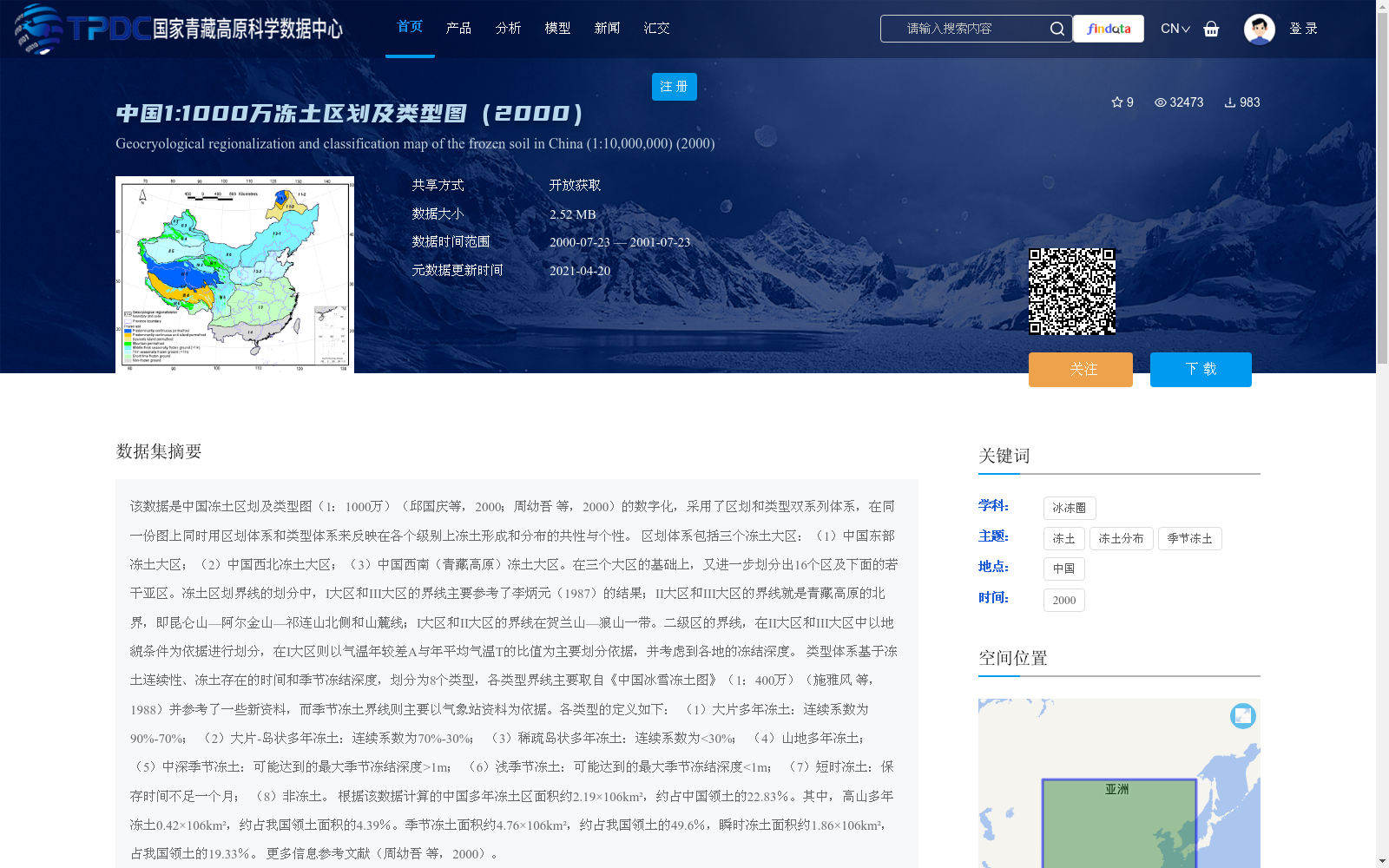
该数据是中国冻土区划及类型图(1:1000万)(邱国庆等,2000;周幼吾 等,2000)的数字化,采用了区划和类型双系列体系,在同一份图上同时用区划体系和类型体系来反映在各个级别上冻土形成和分布的共性与个性。
区划体系包括三个冻土大区:(1)中国东部冻土大区;(2)中国西北冻土大区;(3)中国西南(青藏高原)冻土大区。在三个大区的基础上,又进一步划分出16个区及下面的若干亚区。冻土区划界线的划分中,I大区和III大区的界线主要参考了李炳元(1987)的结果;II大区和III大区的界线就是青藏高原的北界,即昆仑山—阿尔金山—祁连山北侧和山麓线;I大区和II大区的界线在贺兰山—狼山一带。二级区的界线,在II大区和III大区中以地貌条件为依据进行划分,在I大区则以气温年较差A与年平均气温T的比值为主要划分依据,并考虑到各地的冻结深度。
类型体系基于冻土连续性、冻土存在的时间和季节冻结深度,划分为8个类型,各类型界线主要取自《中国冰雪冻土图》(1:400万)(施雅风 等,1988)并参考了一些新资料,而季节冻土界线则主要以气象站资料为依据。各类型的定义如下:
(1)大片多年冻土:连续系数为90%-70%;
(2)大片-岛状多年冻土:连续系数为70%-30%;
(3)稀疏岛状多年冻土:连续系数为<30%;
(4)山地多年冻土;
(5)中深季节冻土:可能达到的最大季节冻结深度>1m;
(6)浅季节冻土:可能达到的最大季节冻结深度<1m;
(7)短时冻土:保存时间不足一个月;
(8)非冻土。
根据该数据计算的中国多年冻土区面积约2.19×10⁶km²,约占中国领土的22.83%。其中,高山多年冻土0.42×10⁶km²,约占我国领土面积的4.39%。季节冻土面积约4.76×10⁶km²,约占我国领土的49.6%,瞬时冻土面积约1.86×10⁶km²,占我国领土的19.33%。
更多信息参考文献(周幼吾 等,2000)。
This dataset is the digitization of the 1:10 million Map of Frozen Soil Regionalization and Types in China (Qiu et al., 2000; Zhou et al., 2000), which adopts a dual framework of regionalization and classification. The two systems are used together on the same map to reflect the commonalities and distinct characteristics of frozen soil formation and distribution across all hierarchical levels.
The regionalization framework comprises three major frozen soil regions: (1) Eastern China Frozen Soil Region; (2) Northwestern China Frozen Soil Region; (3) Southwestern China (Qinghai-Tibet Plateau) Frozen Soil Region. Based on these three major regions, 16 secondary regions and several subordinate sub-regions are further delineated.
For the delimitation of frozen soil regionalization boundaries, the boundary between Region I and Region III primarily draws on the results of Li (1987). The boundary between Region II and Region III is the northern limit of the Qinghai-Tibet Plateau, namely the northern foot and piedmont lines of the Kunlun, Altun and Qilian Mountains. The boundary between Region I and Region II runs along the Helan and Langshan Mountains.
The boundaries of secondary regions are delineated based on geomorphic conditions in Regions II and III, while in Region I, the ratio of annual temperature range (A) to annual mean temperature (T) serves as the primary delimitation criterion, with consideration of local freezing depths.
The classification system is divided into 8 types based on three criteria: permafrost continuity, duration of frozen soil existence, and seasonal freezing depth. The boundaries of most types are primarily sourced from the 1:4 million Map of Snow and Frozen Soil in China (Shi et al., 1988) with reference to recent data, whereas the boundaries of seasonally frozen soil types are mainly based on meteorological station observations. The definitions of each type are as follows:
1. Extensive permafrost: continuous coverage coefficient of 90%–70%;
2. Extensive-island permafrost: continuous coverage coefficient of 70%–30%;
3. Sparse island permafrost: continuous coverage coefficient <30%;
4. Mountain permafrost;
5. Moderately deep seasonally frozen soil: maximum possible seasonal freezing depth >1 m;
6. Shallow seasonally frozen soil: maximum possible seasonal freezing depth <1 m;
7. Temporary frozen soil: duration of existence less than one month;
8. Non-frozen soil.
Based on this dataset, the calculated area of permafrost regions in China is approximately 2.19×10⁶ km², accounting for about 22.83% of China's total territorial area. Of this, alpine permafrost covers an area of 0.42×10⁶ km², accounting for approximately 4.39% of China's territorial area. The area of seasonally frozen soil is approximately 4.76×10⁶ km², making up 49.6% of China's territorial area, while the area of transient frozen soil is approximately 1.86×10⁶ km², accounting for 19.33% of China's total territorial area.
For additional information, please refer to Zhou et al. (2000).
提供机构:
周幼吾,郭东信,邱国庆
创建时间:
2011-09-25
搜集汇总
数据集介绍
背景与挑战
背景概述
该数据集是中国1:1000万冻土区划及类型图的数字化版本(2000年),采用区划和类型双系列体系,全面反映中国冻土的分布特征。区划体系将中国冻土划分为东部、西北和西南(青藏高原)三个大区,并细分为16个区及亚区;类型体系基于冻土连续性、存在时间和季节冻结深度,定义了8种冻土类型,如大片多年冻土、季节冻土等。根据数据计算,中国多年冻土区面积约2.19×10^6 km²,占国土面积的22.83%,季节冻土和瞬时冻土分别占49.6%和19.33%,为冻土研究提供了重要基础数据。
以上内容由遇见数据集搜集并总结生成


