青藏高原东北部祁连山地区250m分辨率多年冻土空间分带指数图(2023)
收藏国家青藏高原科学数据中心2023-10-08 更新2024-03-07 收录
下载链接:
https://data.tpdc.ac.cn/zh-hans/data/10c8b90f-8fec-43ca-b6ab-605cd7fa3c31
下载链接
链接失效反馈官方服务:
资源简介:
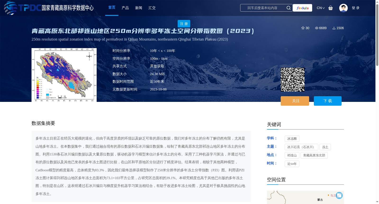
多年冻土目前正在经历大规模的退化,但由于高度异质的环境以及缺乏可靠的原位数据,我们对多年冻土的分布了解仍然有限,尤其是山地多年冻土。在本数据集中,我们通过融合现有的原位数据和石冰川编目数据集,绘制了青藏高原东北部祁连山地区多年冻土的分布图。利用1530条石冰川编目数据以及大量原位数据,驱动机器学习模型来估计多年冻土的分布。采用了三种机器学习算法,并通过与已有的原位数据以及其他已发表的多年冻土图进行比较,在山区和平原地区分别进行了精度评估。结果表明,相较于其他两种模型,CatBoost模型的精度最高,总体精度为83.3%,因此我们最终选择该模型制作了250米分辨率的多年冻土分带指数(PZI)图。利用该PZI冻土图计算得到祁连山地区多年冻土总面积为73.1×10³平方公里,占研究区总面积的39.1%。本研究精度也高于其他已出版的多年冻土图,特别是在山区,这表明通过石冰川编目与梯度提升机器学习算法相结合,有助于改进多年冻土绘图,尤其是对于极具挑战性的山地多年冻土。
Permafrost is currently undergoing widespread degradation, but our understanding of its distribution remains limited, particularly for mountain permafrost, due to highly heterogeneous environments and the lack of reliable in-situ data. In this dataset, we mapped permafrost distribution in the Qilian Mountains of the northeastern Tibetan Plateau by fusing existing in-situ data and rock glacier inventory datasets. We utilized 1,530 rock glacier inventory entries and extensive in-situ data to train machine learning models for estimating permafrost distribution. Three machine learning algorithms were employed, and accuracy assessments were conducted separately for mountainous and plain regions by comparing with existing in-situ data and other published permafrost maps. The results demonstrate that the CatBoost model achieved the highest accuracy, with an overall accuracy of 83.3%, outperforming the other two models. Therefore, we ultimately selected this model to generate a 250-meter resolution Permafrost Zonation Index (PZI) map. Using this PZI permafrost map, we calculated that the total permafrost area in the Qilian Mountains is 73.1 × 10³ km², accounting for 39.1% of the total study area. The accuracy of this study is also higher than that of other published permafrost maps, especially in mountainous areas, suggesting that combining rock glacier inventories with gradient-boosted machine learning algorithms can facilitate improved permafrost mapping, particularly for the highly challenging mountain permafrost.
提供机构:
胡仲毅,闫德昭,冯敏,徐瑾昊
创建时间:
2023-08-05
搜集汇总
数据集介绍
背景与挑战
背景概述
该数据集提供了青藏高原东北部祁连山地区250米分辨率的多年冻土空间分带指数图(2023),通过融合原位数据和石冰川编目数据集,采用CatBoost机器学习算法制作,总体精度为83.3%。数据集显示该地区多年冻土总面积为73.1×10³平方公里,占研究区总面积的39.1%,适用于冰冻圈研究,特别是山地多年冻土分布分析。
以上内容由遇见数据集搜集并总结生成


