中国 1:400万植被图(1979)
收藏国家青藏高原科学数据中心2021-11-28 更新2024-03-01 收录
下载链接:
https://data.tpdc.ac.cn/zh-hans/data/6d9d92f7-854d-4314-bf0f-e24ec02527e2
下载链接
链接失效反馈官方服务:
资源简介:
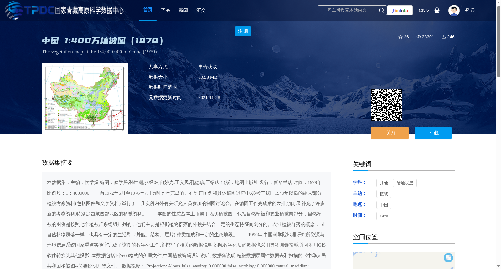
本数据集:主编:侯学煜
编图:候学煜,孙世洲,张经炜,何妙光.王义凤,孔德珍,王绍庆
出版:地图出版社
发行:新华书店
时间:1979年
比例尺:1:4000000
自1972年5月至1976年7月历时五年完成的。在制订图例和具体编图过程中,参考了我国1949年以后的绝大部分植被考察资料(包括图件和文字资料),举行了十几次所内外有关研究人员参加的制图讨论会。在编图工作完成后的发排期间,又补充了许多新的考察资料,特别是西藏西部地区的植被资料。
本图的性质基本上市属于现状植被图,包括自然植被和农业植被两部分,自然植被的图例是按照七个植被群系纲组排列的,他们主要是根据植物群落的外貌并结合一定的生态特征而划分的。农业植被群落的概念,同自然植物群落一样,也具有一定的生活型(外貌、结构、层片),种类组成和一定的生态地段。
1990年,中国科学院地理研究所资源与环境信息系统国家重点实验室完成了该图的数字化工作,并撰写了相关的数据说明文档,数字化后的数据也采用等积圆锥投影,并可利用GIS软件转换为其他投影.
本数据包括1个e00格式的矢量文件,中国植被编码设计说明, 数据集说明,植被数据层属性数据表和扫描的《中华人民共和国植被图--简要说明》等文件。
数据投影:
Projection: Albers
false_easting: 0.000000
false_northing: 0.000000
central_meridian: 110.000000
standard_parallel_1: 25.000000
standard_parallel_2: 47.000000
latitude_of_origin: 0.000000
Linear Unit: Meter (1.000000)
Geographic Coordinate System: Unknown
Angular Unit: Degree (0.017453292519943299)
Prime Meridian: Greenwich (0.000000000000000000)
Datum: D_Unknown
Spheroid: Clarke_1866
Semimajor Axis: 6378206.400000000400000000
Semiminor Axis: 6356583.799999999800000000
Inverse Flattening: 294.978698213901000000
Dataset Editor: Hou Xueyu
Cartographic Compilation: Hou Xueyu, Sun Shizhou, Zhang Jingwei, He Miaoguang, Wang Yifeng, Kong Dezhen, Wang Shaoqing
Publisher: Cartographic Publishing House
Distributor: Xinhua Bookstore
Publication Year: 1979
Scale: 1:4000000
This dataset was completed over a five-year period from May 1972 to July 1976. During the development of the cartographic legend and specific compilation work, most of China's post-1949 vegetation survey data (including maps and written materials) were referenced, and over ten cartographic seminars attended by relevant researchers from inside and outside the institute were held. During the typesetting stage after the completion of the cartographic work, numerous new survey data were supplemented, especially vegetation data from western Tibet.
This map is essentially a current vegetation map, comprising two parts: natural vegetation and agricultural vegetation. The legend for natural vegetation is arranged according to seven vegetation formation groups, which are primarily classified based on the physiognomy of plant communities combined with specific ecological characteristics. The concept of agricultural vegetation communities, similar to natural plant communities, also possesses defined life forms (physiognomy, structure, synusia), species composition, and specific ecological sites.
In 1990, the State Key Laboratory of Resources and Environmental Information System, Institute of Geographic Sciences and Natural Resources Research, Chinese Academy of Sciences completed the digitization of this map and compiled relevant data description documents. The digitized data adopted the equal-area conic projection and can be converted to other projections using GIS software.
This dataset includes one vector file in e00 format, the design description of China's vegetation coding, dataset description, attribute data table of vegetation data layers, and scanned documents such as *Brief Introduction to the Vegetation Map of the People's Republic of China*.
Data Projection:
Projection: Albers
false_easting: 0.000000
false_northing: 0.000000
central_meridian: 110.000000
standard_parallel_1: 25.000000
standard_parallel_2: 47.000000
latitude_of_origin: 0.000000
Linear Unit: Meter (1.000000)
Geographic Coordinate System: Unknown
Angular Unit: Degree (0.017453292519943299)
Prime Meridian: Greenwich (0.000000000000000000)
Datum: D_Unknown
Spheroid: Clarke_1866
Semimajor Axis: 6378206.400000000400000000
Semiminor Axis: 6356583.799999999800000000
Inverse Flattening: 294.978698213901000000
提供机构:
侯学煜,孙世洲,张经炜,何妙光,王义凤,孔德珍,王绍庆
创建时间:
2012-04-01
搜集汇总
数据集介绍
背景与挑战
背景概述
中国1:400万植被图(1979)是由侯学煜等人主编,历时五年完成的现状植被图,包括自然植被和农业植被两部分,采用等积圆锥投影,数字化后可用于GIS软件转换。数据集包含e00格式矢量文件、植被编码设计说明、属性数据表等文件。
以上内容由遇见数据集搜集并总结生成


