中亚-西亚地区资源环境基础地理数据集
收藏地球大数据科学工程2024-03-04 收录
下载链接:
https://data.casearth.cn/sdo/detail/5feae825819aec33049b7bf6
下载链接
链接失效反馈官方服务:
资源简介:
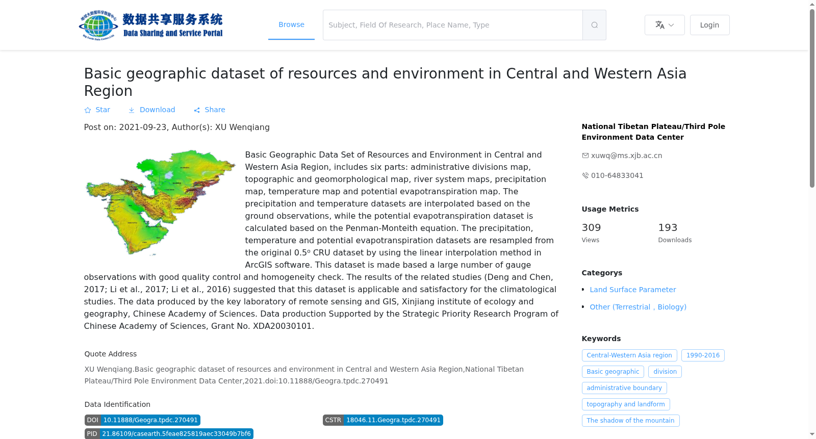
中亚-西亚地区资源环境基础地理数据集主要包括6部分:中亚-西亚地区行政区划图、地形地貌图、水系图、年累积降水图、年平均温度图和潜在蒸散发分布图。其中行政区划图为最新的国家边界数据,地形地貌图DEM分辨率为90米,水系图为最新的一级河流矢量数据。年累积降水图和年平均温度图中降水和温度数据由长时间序列的站点数据插值得到,而潜在蒸散发分布图中的潜在蒸散数据是基于Penman-Monteith公式计算得到,降水、温度和潜在蒸散数据均由原始0.5°的CRU数据基于ArcGIS软件的双线性插值方法重采样为0.25°得到,且数据集经过严格的质量控制和一致性检查,相关研究(Deng and Chen, 2017; Li et al., 2017; Li et al., 2016)表明该数据集在中西亚地区对气候相关研究具有很好的适用性。数据由中国科学院新疆生态与地理研究所遥感与GIS重点实验室生产,生产费用由“中国科学院战略性先导科技专项XDA20030101资助”。
The Geospatial Basic Resource and Environment Dataset for Central and West Asia comprises six core components: the administrative division map, topographic and geomorphic map, drainage map, annual cumulative precipitation map, annual average temperature map, and potential evapotranspiration distribution map of Central and West Asia. Specifically, the administrative division map utilizes the latest national boundary dataset; the DEM of the topographic and geomorphic map has a resolution of 90 meters; and the drainage map adopts the latest first-order river vector data. The precipitation and temperature data for the annual cumulative precipitation map and annual average temperature map are interpolated from long-term time series station observations. The potential evapotranspiration data in the distribution map is calculated via the Penman-Monteith equation. All precipitation, temperature and potential evapotranspiration datasets are resampled from the original 0.5° resolution CRU data to a 0.25° spatial resolution using the bilinear interpolation method implemented in ArcGIS software. Additionally, the entire dataset has undergone rigorous quality control and consistency checks. Relevant studies (Deng and Chen, 2017; Li et al., 2017; Li et al., 2016) have verified that this dataset exhibits excellent applicability for climate-related research in Central and West Asia. This dataset was developed and produced by the Key Laboratory of Remote Sensing and GIS, Xinjiang Institute of Ecology and Geography, Chinese Academy of Sciences, with funding support from the Strategic Priority Research Program of the Chinese Academy of Sciences (Grant No. XDA20030101).
提供机构:
国家青藏高原科学数据中心
搜集汇总
数据集介绍
背景与挑战
背景概述
中亚-西亚地区资源环境基础地理数据集包含六类基础地理信息图,数据基于地面观测和CRU数据集插值计算,适用于气候学研究,由中国科学院相关实验室生产。
以上内容由遇见数据集搜集并总结生成


