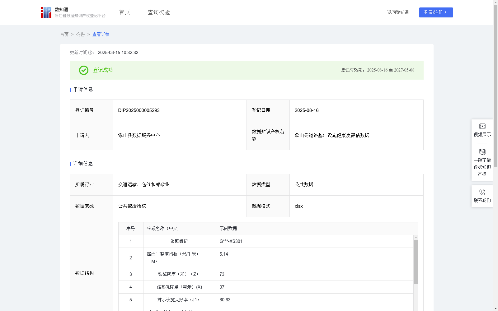
象山县道路基础设施健康度评估数据
收藏浙江省数据知识产权登记平台2025-08-15 更新2025-08-16 收录
下载链接:
https://www.zjip.org.cn/home/announce/trends/164900
下载链接
链接失效反馈官方服务:
资源简介:
象山县道路健康度评估结果可以驱动养护决策系统自动生成维修工单,优先处置桥梁伸缩缝异常位移区域与隧道照明薄弱路段,同步向导航平台推送路况预警信息。针对雨季易涝点,系统可联动排水管网控制系统预降水位,并结合历史健康度变化趋势优化资金投放优先级。这种模式突破传统人工巡检的时空局限,构建起覆盖道路全生命周期的健康监护网络,有力支撑韧性城市建设目标,助力城市基础设施的精细化管理与科学决策。通过持续监测道路结构健康状态,辅助管理部门精准识别护栏缺损、路基渗水等潜在风险点,及时排除交通安全隐患。借助多源数据融合分析,可优化养护资源配置,优先处理桥隧关键节点病害,延长道路服役周期。根据国际平整度测量方法获得路面平整度指数(IRI)(米/千米)M;根据每公里纵向裂缝总长度获得裂缝密度(米)Z;根据路面检测报告中的检测点位最大沉降深度获得路基沉降量(米)X;根据道路设施信息获得排水设施完好率(%);根据逆反射系数测量值获得标线清晰度(毫坎德拉)S;根据路面检测报告中的每公里护栏缺损的变形点位数量获得J2;根据位移量与允许阈值的百分比获得桥梁伸缩位移Wa;根据隧道检测报告中的照度检测合格区段占比获得隧道照明达标率(%)Sa;根据道路路龄与设计使用年限比值获得服役年限系数Ya;将所有采集汇总数据采用缺陷累积扣分法,通过线性加权叠加法进行计算:Y=MAX(0,MIN(100,100-(Mx1.0+Zx0.2+Xx0.3+(100-J1)x1.2+(550-S)x0.02+J2x3.5+Wax0.15+(100-Sa)x0.8+Yax5))),最终获得综合风险值,当值在0-30区间时,为高危风险道路,应立即对该段道路重新做详细的道路安全检查解决所存在安全风险;当值在31-60区间时,为正常风险道路,说明该道路可以正常进行日常行驶,造成磨损是随时间正比上升的;当值在61-100区间时,为轻微风险道路,说明该道路可能是新服役道路,或者是日常维护工作是否到位等。
The road health assessment results of Xiangshan County can drive the maintenance decision-making system to automatically generate maintenance work orders, prioritize the treatment of areas with abnormal displacement of bridge expansion joints and sections with weak tunnel lighting, and simultaneously push traffic condition warnings to navigation platforms. For waterlogging-prone sections in rainy seasons, the system can link with the drainage pipe network control system to preemptively lower the water level, and optimize the priority of fund allocation by combining historical health change trends. This model breaks through the temporal and spatial limitations of traditional manual inspections, builds a health monitoring network covering the full life cycle of roads, strongly supports the goal of resilient city construction, and facilitates refined management and scientific decision-making for urban infrastructure. Through continuous monitoring of road structural health conditions, it assists management departments in accurately identifying potential risk points such as guardrail defects and subgrade water seepage, and timely eliminates traffic safety hazards. With the help of multi-source data fusion analysis, the allocation of maintenance resources can be optimized, diseases at key bridge and tunnel nodes can be prioritized for treatment, and the service life of roads can be prolonged. Obtain the International Roughness Index (IRI) (m/km) as M based on the international roughness measurement method; obtain the crack density (m) as Z based on the total length of longitudinal cracks per kilometer; obtain the subgrade settlement (m) as X based on the maximum settlement depth of detection points in the pavement inspection report; obtain the drainage facility integrity rate (%) based on road facility information; obtain the marking clarity (millicandela) as S based on the retroreflectance coefficient measurements; obtain J2 based on the number of deformed points with guardrail defects per kilometer in the pavement inspection report; obtain the bridge expansion displacement Wa based on the percentage of displacement relative to the allowable threshold; obtain the tunnel lighting compliance rate (%) as Sa based on the proportion of qualified sections in illumination detection in the tunnel inspection report; obtain the service life coefficient Ya based on the ratio of road age to the designed service life. All collected and aggregated data are calculated using the defect cumulative deduction method and linear weighted superposition: $Y= ext{MAX}(0, ext{MIN}(100,100-(M imes1.0+Z imes0.2+X imes0.3+(100-J1) imes1.2+(550-S) imes0.02+J2 imes3.5+Wa imes0.15+(100-Sa) imes0.8+Ya imes5)))$, and the comprehensive risk value is finally obtained. When the value is in the range of 0-30, it is a high-risk road, and a detailed road safety inspection of this section should be carried out immediately to resolve the existing safety risks; when the value is in the range of 31-60, it is a normal-risk road, indicating that the road can normally be used for daily driving, and the wear increases proportionally with time; when the value is in the range of 61-100, it is a slightly risky road, indicating that the road may be a newly commissioned road or whether daily maintenance work is properly implemented, etc.
提供机构:
象山县数据服务中心
创建时间:
2025-05-14
搜集汇总
数据集介绍
背景与挑战
背景概述
该数据集包含象山县道路基础设施健康度评估数据,涵盖路面平整度、裂缝密度、路基沉降量等11个关键指标,共1001条记录,每月更新一次。数据应用于道路健康度评估、养护决策系统及路况预警,支持城市基础设施的精细化管理与科学决策。
以上内容由遇见数据集搜集并总结生成


