第三极未来1 km季节冻土最大冻结深度数据集(2050s和2090s)
收藏国家青藏高原科学数据中心2023-03-21 更新2024-02-29 收录
下载链接:
https://data.tpdc.ac.cn/zh-hans/data/6f5ea59d-38a2-4c1e-9ff2-451f51d7381a
下载链接
链接失效反馈官方服务:
资源简介:
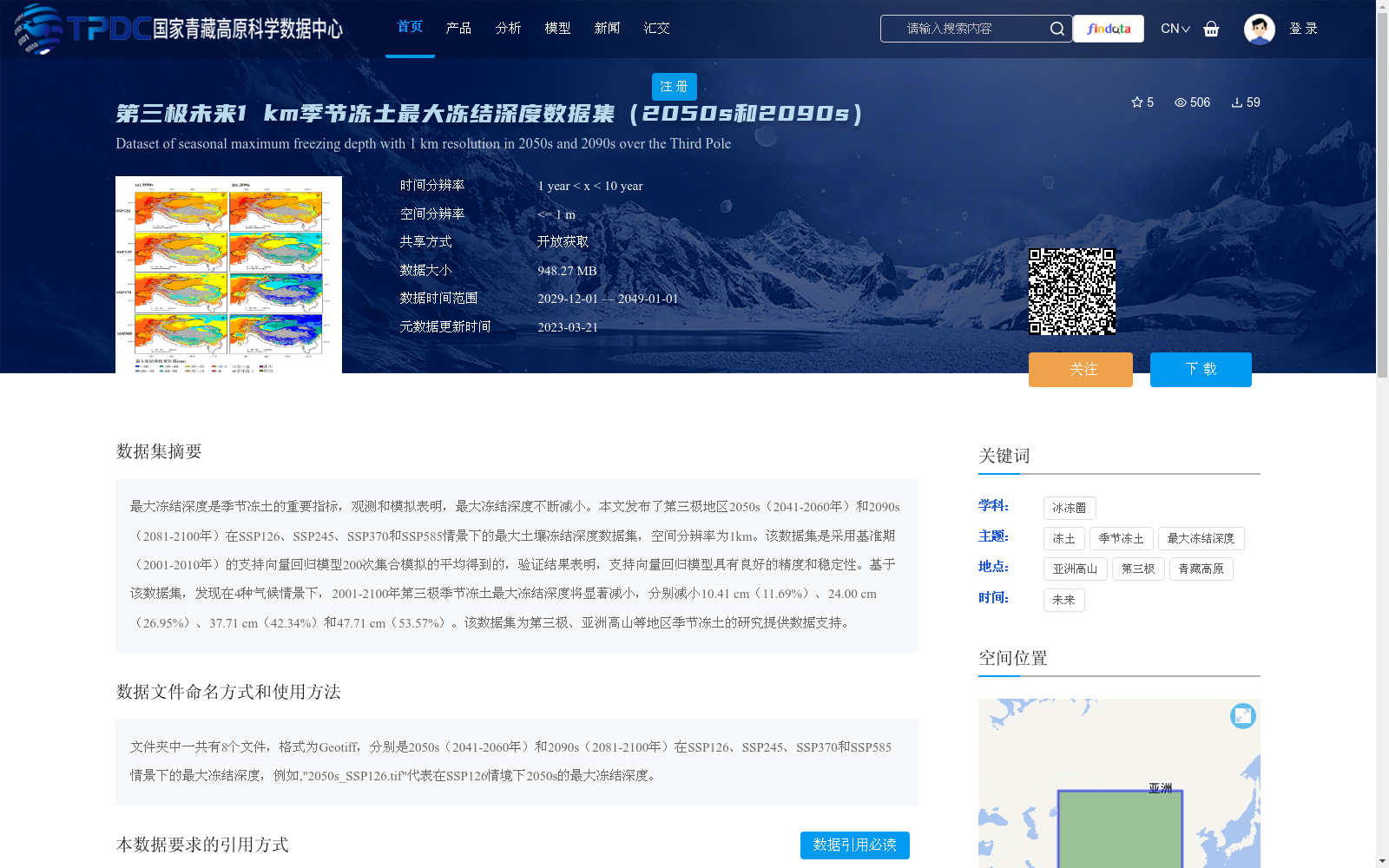
最大冻结深度是季节冻土的重要指标,观测和模拟表明,最大冻结深度不断减小。本文发布了第三极地区2050s(2041-2060年)和2090s(2081-2100年)在SSP126、SSP245、SSP370和SSP585情景下的最大土壤冻结深度数据集,空间分辨率为1km。该数据集是采用基准期(2001-2010年)的支持向量回归模型200次集合模拟的平均得到的,验证结果表明,支持向量回归模型具有良好的精度和稳定性。基于该数据集,发现在4种气候情景下,2001-2100年第三极季节冻土最大冻结深度将显著减小,分别减小10.41 cm(11.69%)、24.00 cm(26.95%)、37.71 cm(42.34%)和47.71 cm(53.57%)。该数据集为第三极、亚洲高山等地区季节冻土的研究提供数据支持。
Maximum frost depth is a critical indicator of seasonally frozen ground. Observations and simulations have shown that maximum frost depth has been decreasing continuously. This study releases a dataset of maximum soil frost depth over the Third Pole region for the 2050s (2041–2060) and 2090s (2081–2100) under four Shared Socioeconomic Pathway (SSP) scenarios: SSP126, SSP245, SSP370, and SSP585, with a spatial resolution of 1 km. This dataset is derived from the average of 200 ensemble simulations using a Support Vector Regression (SVR) model trained on the baseline period (2001–2010). Validation results demonstrate that the SVR model exhibits excellent accuracy and stability. Based on this dataset, it is found that the maximum frost depth of seasonally frozen ground over the Third Pole region will decrease remarkably during 2001–2100 under the four climate scenarios, with reductions of 10.41 cm (11.69%), 24.00 cm (26.95%), 37.71 cm (42.34%), and 47.71 cm (53.57%), respectively. This dataset provides valuable data support for studies on seasonally frozen ground in the Third Pole, the Asian High Mountains and other relevant regions.
提供机构:
王冰泉,冉有华
创建时间:
2022-12-05
搜集汇总
数据集介绍
背景与挑战
背景概述
该数据集提供了第三极地区未来季节冻土最大冻结深度的预测数据,覆盖2050s(2041-2060年)和2090s(2081-2100年)两个时期,包含SSP126、SSP245、SSP370和SSP585四种气候情景,空间分辨率为1公里。数据基于支持向量回归模型模拟生成,验证表明模型精度良好,预测显示在2001-2100年间,四种情景下最大冻结深度将显著减小10.41至47.71厘米,为研究第三极冻土变化提供关键支持。
以上内容由遇见数据集搜集并总结生成


