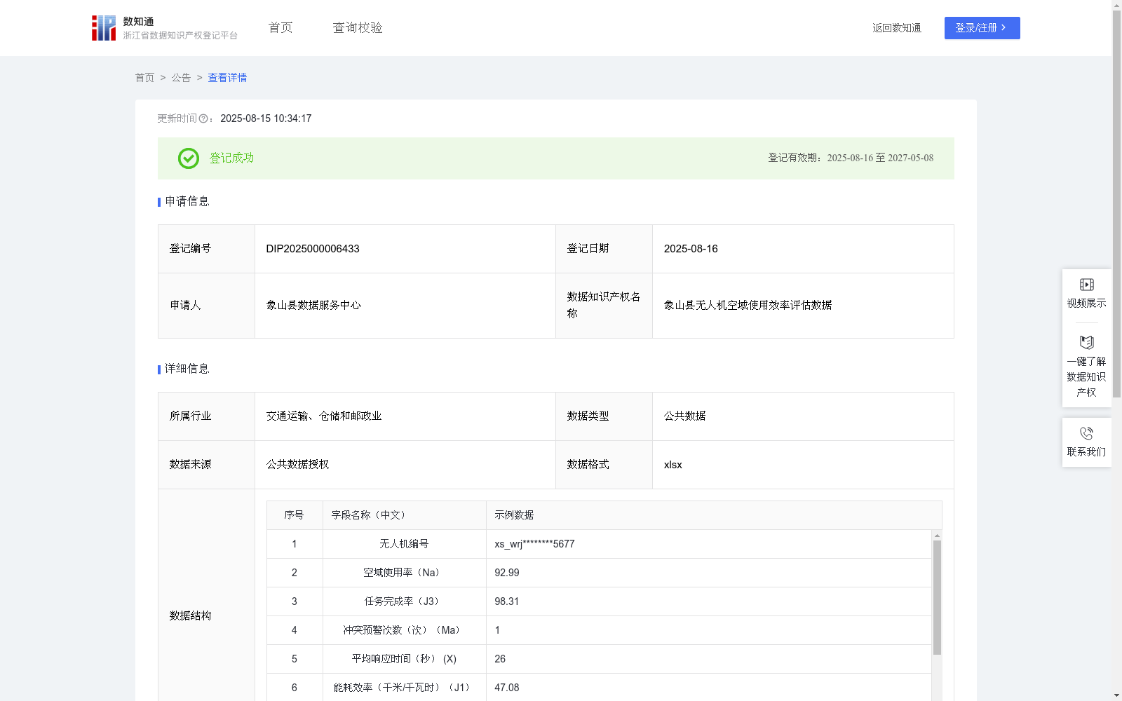
象山县无人机空域使用效率评估数据
收藏浙江省数据知识产权登记平台2025-08-15 更新2025-08-16 收录
下载链接:
https://www.zjip.org.cn/home/announce/trends/164911
下载链接
链接失效反馈官方服务:
资源简介:
无人机空域使用效率评估数据可为城市低空交通管理提供智能化决策支持。通过量化分析空域资源利用、飞行安全合规性和运营效益等核心维度,帮助交通管理部门动态优化空域分配方案,识别高风险运营主体,并为无人机企业提供精准的效率改进方向。模型实施后能显著提升空域资源周转率,降低飞行冲突风险,同时通过数据驱动的绩效评估,促进运营商加强设备维护、优化航线规划并完善应急预案,最终实现低空经济安全高效发展。这套评估体系既强化了监管部门的精细化管控能力,也为行业健康有序竞争建立了标准化参照依据。根据无人机厂家唯一编号加县特殊标记获得无人机编号;根据ADS-B监测数据获得空域使用率(%)Na;根据营运平台统计数据获得任务完成率(%)J3;根据空管系统记录获得冲突预警次数(次)Ma;根据任务执行日志获得平均响应时间(秒)X;根据无人机电池管理API获得能耗效率(千米/千瓦时)J1;根据气象API数据和无人机飞行记录获得气象适应指数S;根据无人机运维检测系统数据获得设备完好率(%)J2;根据营运平台统计数据获得违规操作次数Ac;所有采集汇总数据先通过线性加权法进行计算:Y=Nax0.25+J3x0.3-Max2-Xx0.1+J1x0.15+Sx3+J2x0.2-Acx5,最终获得象山县无人机空域使用效率评估值,当评估值>=80分,为优秀,可申请扩大空域权限;当评估值在70-79分,维持当前运营规模;当评估值在60-69分,需提交无人机飞行航线优化方案;当评估值<60分,触发监管审查,排查无人机设备、无人机操作人员记录、无人机航线管理等。
UAV airspace utilization efficiency assessment data provides intelligent decision support for urban low-altitude traffic management. By quantitatively analyzing core dimensions including airspace resource utilization, flight safety compliance and operational benefits, it helps traffic management departments dynamically optimize airspace allocation plans, identify high-risk operating entities, and provide precise efficiency improvement directions for UAV enterprises. After the model is deployed, it can significantly improve airspace resource turnover rate and reduce flight conflict risks. Meanwhile, through data-driven performance evaluation, it promotes operators to strengthen equipment maintenance, optimize route planning and improve emergency response plans, ultimately realizing the safe and efficient development of the low-altitude economy. This assessment system not only strengthens the refined management and control capabilities of regulatory authorities, but also establishes standardized reference bases for the healthy and orderly competition of the industry. UAV identification numbers are generated based on the unique manufacturer number plus the county-specific marker; Airspace utilization rate (%, marked as Na) is obtained from ADS-B monitoring data; Task completion rate (%, marked as J3) is acquired from operation platform statistics; Conflict warning times (unit: times, marked as Ma) are derived from air traffic control (ATC) system records; Average response time (unit: seconds, marked as X) is obtained from task execution logs; Energy consumption efficiency (unit: kilometers per kilowatt-hour, marked as J1) is acquired from the UAV battery management API; Meteorological adaptation index (marked as S) is obtained from meteorological API data and UAV flight records; Equipment integrity rate (%, marked as J2) is collected from the UAV operation and maintenance detection system data; Number of violation operations (marked as Ac) is acquired from operation platform statistics. All collected and aggregated data are calculated via the linear weighting method: Y = Na × 0.25 + J3 × 0.3 - Ma × 2 - X × 0.1 + J1 × 0.15 + S × 3 + J2 × 0.2 - Ac × 5, to obtain the final UAV airspace utilization efficiency assessment value for Xiangshan County. The corresponding rating criteria are as follows: 1. Excellent grade: When the assessment score is ≥ 80, the operator may apply for expanded airspace authorization; 2. Maintain current operation scale: When the score is between 70 and 79 (inclusive), the operator shall retain the current operation scale; 3. Submit route optimization plan: When the score is between 60 and 69 (inclusive), the operator shall submit a UAV flight route optimization plan; 4. Trigger regulatory review: When the score is < 60, regulatory review shall be initiated to inspect UAV equipment, UAV operator records, UAV route management and other related aspects.
提供机构:
象山县数据服务中心
创建时间:
2025-05-28
搜集汇总
数据集介绍
以上内容由遇见数据集搜集并总结生成


