闪电河流域土壤温湿度无线传感器网络观测数据集(2019)
收藏国家青藏高原科学数据中心2021-06-10 更新2024-03-01 收录
下载链接:
https://data.tpdc.ac.cn/zh-hans/data/c6504fb2-98dd-42f7-9f0d-b714ca1fafaf
下载链接
链接失效反馈官方服务:
资源简介:
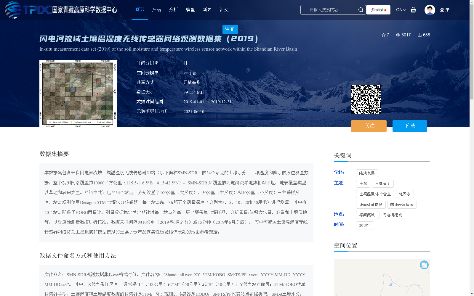
本数据集包含来自闪电河流域土壤温湿度无线传感器网络(以下简称SMN-SDR)的34个站点的土壤水分、土壤温度和降水的原位测量数据。整个观测网络覆盖约10000平方公里(115.5-116.5°E,41.5-42.5°N)。SMN-SDR 所覆盖的闪电河流域地势相对平坦,地表覆盖类型以草地和农田为主。网络中共计包含34个站点,分别设置了100公里(大尺度)、50公里(中尺度)和10公里(小尺度)三种采样尺度。站点观测使用Decagon 5TM 土壤水分传感器,每个站点统一按照五个测量深度(分别为3、5、10、20和50厘米)进行测量,其中有20个站点配备了HOBO雨量计。测量数据稳定后定期针对每个站点的每一层土壤采集土壤样品,分析重量/体积含水量、容重和土壤质地等,以对原始测量数据进行校准。数据采样间隔为10分钟(2019年6月之前)或15分钟(2019年6月之后)。
闪电河流域土壤温湿度无线传感器网络将为卫星反演和模型模拟的土壤水分产品真实性检验提供长期的地面参考数据。
This dataset contains in-situ measured data of soil moisture, soil temperature and precipitation from 34 stations of the Soil Temperature and Moisture Wireless Sensor Network in the Shandian River Basin (hereinafter referred to as SMN-SDR). The entire observation network covers an area of approximately 10,000 square kilometers, spanning 115.5–116.5°E and 41.5–42.5°N. The Shandian River Basin covered by SMN-SDR features relatively flat terrain, with grassland and farmland as its dominant land cover types. The network consists of 34 stations in total, which are deployed with three sampling scales: 100 km (large-scale), 50 km (mesoscale), and 10 km (small-scale). Soil moisture observations at each station adopt Decagon 5TM soil moisture sensors, and uniform measurements are conducted at five depths: 3 cm, 5 cm, 10 cm, 20 cm, and 50 cm. Among these stations, 20 are equipped with HOBO rain gauges. After the measurement data stabilizes, soil samples are periodically collected from each soil layer at every station for analyses of gravimetric/volumetric water content, bulk density, soil texture and other relevant parameters, so as to calibrate the original measured data. The data sampling interval is 10 minutes prior to June 2019, and 15 minutes after that time.
The SMN-SDR in the Shandian River Basin will provide long-term ground reference data for the validation of satellite-retrieved and model-simulated soil moisture products.
提供机构:
赵天杰,姬大彬,蒋玲梅,崔倩,陈德清,郑景耀,张子谦,胡路,施建成
创建时间:
2021-06-09
搜集汇总
数据集介绍
背景与挑战
背景概述
该数据集是2019年闪电河流域土壤温湿度无线传感器网络的观测数据,包含34个站点的土壤水分、土壤温度和降水原位测量,覆盖约10000平方公里,采用多尺度采样(100公里、50公里、10公里)和五个测量深度(3至50厘米),数据采样间隔为10或15分钟。其主要特点是为卫星反演和模型模拟的土壤水分产品提供长期地面验证数据,支持水循环和能量平衡研究。
以上内容由遇见数据集搜集并总结生成


