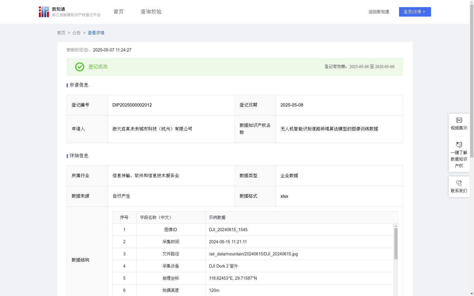
无人机智能识别道路坍塌算法模型的图像训练数据
收藏浙江省数据知识产权登记平台2025-05-07 更新2025-05-08 收录
下载链接:
https://www.zjip.org.cn/home/announce/trends/127890
下载链接
链接失效反馈官方服务:
资源简介:
无人机智能识别道路坍塌算法模型的图像训练数据的应用场景主要集中在提升AI模型对道路坍塌的识别能力和准确度。通过对这些数据的训练,AI模型能够更有效地支撑无人机在复杂地形环境下的全天候灾害监测任务,包括山区公路的路基沉降预警、矿区运输道路的路面裂缝检测、山体滑坡等场景。基于多边形标注与地质数据库的联动分析,能够为道路养护单位、应急管理部门提供塌方范围三维可视化报告,支撑交通管制决策、灾后应急通道规划及基础设施安全评估,显著提升地质灾害响应时效性。1、数据来源:原始数据通过自有智能无人机拍摄采集,记录图像ID、采集时间、文件路径、采集设备、地理坐标、拍摄高度、环境参数、多边形标注区域等数据,采用三维点云融合技术清洗异常数据。
2、数据预处理与标注:①对原始数据按7:2:1比例划分训练集/验证集/测试集;②采用多级标注体系:一级标签(坍塌/正常),二级标签(路基沉降/路面裂缝/山体滑坡等)。③关关联要素标注包含地质结构、排水系统状况、护栏变形量等关键特征。
3、模型选择和初始化:采用YOLOv5预训练模型,并初始化模型参数,设置合理的超参数:学习率0.001-0.0001动态调整,批量大小16,锚框参数根据拍摄图像特征优化;同时集成注意力机制增强小目标检测能力。
4、模型训练:使用PyTorch框架实施分布式训练,设置训练时长,采用迁移学习策略,冻结底层特征提取层参数,引入Mosaic数据增强提升复杂场景适应能力,设置早停机制(patience=15)防止过拟合。
5、模型评估:① 构建多维评估体系:基础指标(mAP@0.5)、夜间检测率、误报率、漏报率。② 设置渐进式测试:单点坍塌→连续路段损毁→复杂地形(桥梁/隧道)→地质灾害联动四阶段验证。
6、模型优化:优化多光谱融合推理引擎,保障推理速度,并构建区域性地质特征库。
The application scenarios of the image training data for the UAV intelligent road collapse recognition algorithm model mainly focus on improving the recognition capability and accuracy of the AI model for road collapse. Through training on this data, the AI model can more effectively support the all-weather disaster monitoring missions of UAVs in complex terrain environments, including subgrade settlement warning of mountainous highways, pavement crack detection of mining area transportation roads, and landslide scenarios. Based on the joint analysis of polygon annotations and geological databases, it can provide three-dimensional visualization reports of collapse scope for road maintenance units and emergency management departments, support traffic control decision-making, post-disaster emergency channel planning, and infrastructure safety assessment, significantly improving the timeliness of geological disaster response.
1. Data Source: The original data is collected via self-developed intelligent UAVs, recording data such as image ID, collection time, file path, collection equipment, geographic coordinates, shooting altitude, environmental parameters, and polygon annotation areas. Abnormal data is cleaned using 3D point cloud fusion technology.
2. Data Preprocessing and Annotation: ① Divide the original data into training set/validation set/test set at a ratio of 7:2:1; ② Adopt a multi-level annotation system: first-level labels (collapse/normal), second-level labels (subgrade settlement/pavement crack/landslide, etc.). ③ Associated feature annotations include key features such as geological structure, drainage system status, and guardrail deformation.
3. Model Selection and Initialization: The pre-trained YOLOv5 model is adopted, with model parameters initialized and reasonable hyperparameters set: dynamically adjusted learning rate of 0.001-0.0001, batch size of 16, and anchor box parameters optimized based on the characteristics of the captured images; meanwhile, an attention mechanism is integrated to enhance the small object detection capability.
4. Model Training: Distributed training is implemented using the PyTorch framework, with training duration set, a transfer learning strategy adopted, the parameters of the underlying feature extraction layer frozen, Mosaic data augmentation introduced to improve the adaptability to complex scenarios, and an early stopping mechanism (patience=15) set to prevent overfitting.
5. Model Evaluation: ① Construct a multi-dimensional evaluation system: basic metrics (mAP@0.5), night detection rate, false positive rate, and false negative rate. ② Set up progressive testing: four-stage verification of single-point collapse → continuous road section damage → complex terrain (bridge/tunnel) → geological disaster linkage.
6. Model Optimization: Optimize the multispectral fusion inference engine to ensure inference speed, and build a regional geological feature database.
提供机构:
浙大启真未来城市科技(杭州)有限公司
创建时间:
2025-04-07
搜集汇总
数据集介绍
背景与挑战
背景概述
该数据集是用于无人机智能识别道路坍塌算法模型的图像训练数据,包含684条记录,每日更新,详细记录了图像ID、采集时间、地理坐标等信息。应用场景包括山区公路的路基沉降预警和矿区运输道路的路面裂缝检测,旨在提升AI模型对道路坍塌的识别能力和准确度。
以上内容由遇见数据集搜集并总结生成


