喜马拉雅山周边及亚洲水塔区多灾种人口综合风险(2021)
收藏国家青藏高原科学数据中心2022-04-19 更新2024-03-07 收录
下载链接:
https://data.tpdc.ac.cn/zh-hans/data/19581854-1a1a-4de1-8784-c80829f2c927
下载链接
链接失效反馈官方服务:
资源简介:
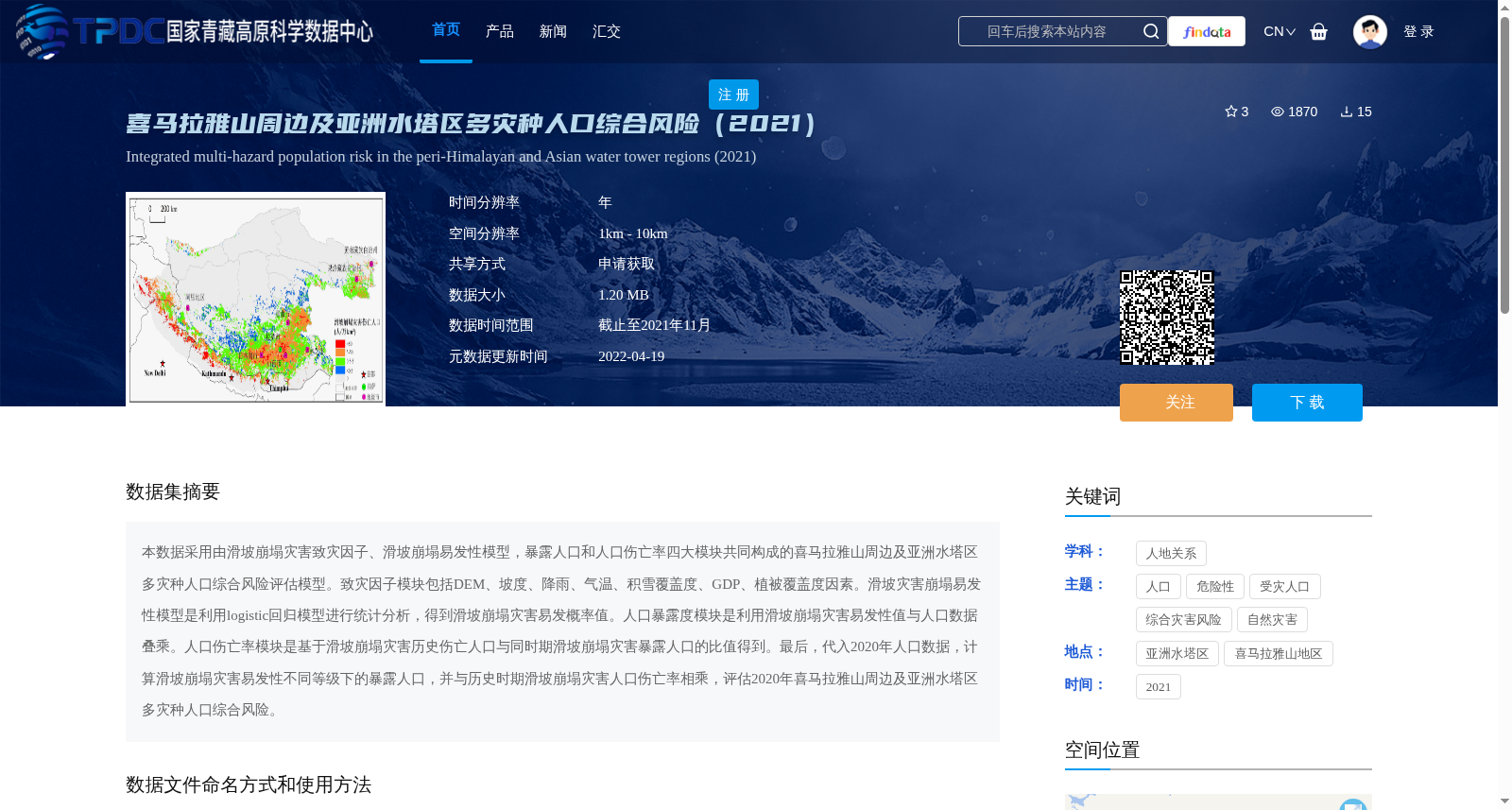
本数据采用由滑坡崩塌灾害致灾因子、滑坡崩塌易发性模型,暴露人口和人口伤亡率四大模块共同构成的喜马拉雅山周边及亚洲水塔区多灾种人口综合风险评估模型。致灾因子模块包括DEM、坡度、降雨、气温、积雪覆盖度、GDP、植被覆盖度因素。滑坡灾害崩塌易发性模型是利用logistic回归模型进行统计分析,得到滑坡崩塌灾害易发概率值。人口暴露度模块是利用滑坡崩塌灾害易发性值与人口数据叠乘。人口伤亡率模块是基于滑坡崩塌灾害历史伤亡人口与同时期滑坡崩塌灾害暴露人口的比值得到。最后,代入2020年人口数据,计算滑坡崩塌灾害易发性不同等级下的暴露人口,并与历史时期滑坡崩塌灾害人口伤亡率相乘,评估2020年喜马拉雅山周边及亚洲水塔区多灾种人口综合风险。
This dataset employs a comprehensive multi-hazard population risk assessment model for the regions surrounding the Himalayas and the Asian Water Tower, which is constructed from four core modules: hazard-inducing factors of landslide and collapse disasters, landslide and collapse susceptibility model, population exposure, and population casualty rate. The hazard-inducing factors module comprises variables including DEM, slope, rainfall, air temperature, snow cover fraction, GDP, and vegetation coverage. The landslide and collapse susceptibility model is developed via statistical analysis using the logistic regression model, generating the susceptibility probability values for landslide and collapse disasters. The population exposure module is calculated by spatially overlaying and multiplying the landslide and collapse susceptibility values with population datasets. The population casualty rate module is derived from the ratio of the historical casualty population of landslide and collapse disasters to the exposed population of such disasters in the same corresponding period. Finally, by utilizing the 2020 population dataset, the exposed population under different susceptibility grades of landslide and collapse disasters is calculated, then multiplied by the historical population casualty rate of these disasters to assess the comprehensive multi-hazard population risk in the Himalayan surrounding regions and the Asian Water Tower area in 2020.
提供机构:
王瑛
创建时间:
2022-02-25
搜集汇总
数据集介绍
背景与挑战
背景概述
该数据集评估2020年喜马拉雅山周边及亚洲水塔区的多灾种人口综合风险,采用基于致灾因子、滑坡崩塌易发性、暴露人口和人口伤亡率的模型,空间分辨率为1km-10km,以Tif格式提供,数据截止至2021年11月,适用于自然灾害风险分析和人地关系研究。
以上内容由遇见数据集搜集并总结生成


