中国降雨侵蚀力数据(2014-2022)
收藏国家青藏高原科学数据中心2025-03-19 更新2025-03-22 收录
下载链接:
https://data.tpdc.ac.cn/zh-hans/data/3ae6537d-5713-4e8b-8f90-7c9ee1369037
下载链接
链接失效反馈官方服务:
资源简介:
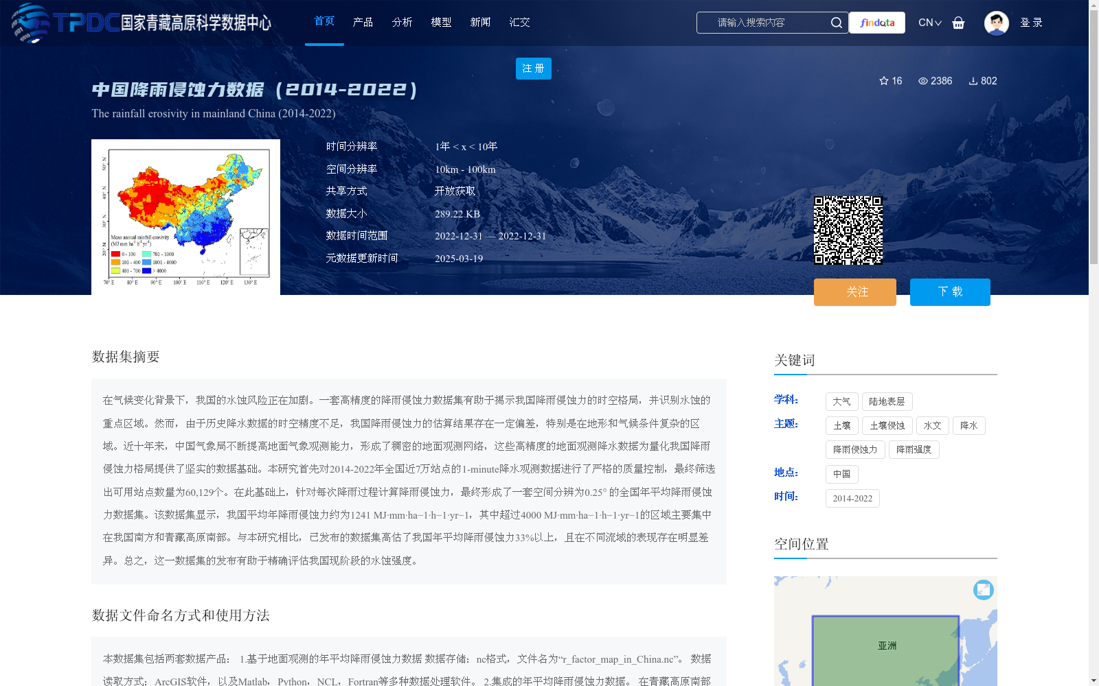
在气候变化背景下,我国的水蚀风险正在加剧。一套高精度的降雨侵蚀力数据集有助于揭示我国降雨侵蚀力的时空格局,并识别水蚀的重点区域。然而,由于历史降水数据的时空精度不足,我国降雨侵蚀力的估算结果存在一定偏差,特别是在地形和气候条件复杂的区域。近十年来,中国气象局不断提高地面气象观测能力,形成了稠密的地面观测网络,这些高精度的地面观测降水数据为量化我国降雨侵蚀力格局提供了坚实的数据基础。本研究首先对2014-2022年全国近7万站点的1-minute降水观测数据进行了严格的质量控制,最终筛选出可用站点数量为60,129个。在此基础上,针对每次降雨过程计算降雨侵蚀力,最终形成了一套空间分辨为0.25° 的全国年平均降雨侵蚀力数据集。该数据集显示,我国平均年降雨侵蚀力约为1241 MJ·mm·ha−1·h−1·yr−1,其中超过4000 MJ·mm·ha−1·h−1·yr−1的区域主要集中在我国南方和青藏高原南部。与本研究相比,已发布的数据集高估了我国年平均降雨侵蚀力33%以上,且在不同流域的表现存在明显差异。总之,这一数据集的发布有助于精确评估我国现阶段的水蚀强度。
Against the backdrop of climate change, the risk of water erosion in China is intensifying. A high-precision rainfall erosivity dataset can help reveal the spatiotemporal patterns of rainfall erosivity in China and identify key areas prone to water erosion. However, due to insufficient spatiotemporal accuracy of historical precipitation data, there are certain deviations in the estimation results of rainfall erosivity in China, especially in areas with complex topography and climatic conditions. Over the past decade, the China Meteorological Administration (CMA) has continuously improved ground meteorological observation capabilities and established a dense ground observation network. These high-precision ground-observed precipitation data provide a solid data foundation for quantifying the patterns of rainfall erosivity in China. This study first conducted strict quality control on 1-minute precipitation observation data from nearly 70,000 national stations during 2014–2022, and finally screened out 60,129 usable stations. On this basis, rainfall erosivity was calculated for each rainfall event, and finally a national annual average rainfall erosivity dataset with a spatial resolution of 0.25° was developed. This dataset shows that the average annual rainfall erosivity in China is approximately 1241 MJ·mm·ha⁻¹·h⁻¹·yr⁻¹, and areas with values exceeding 4000 MJ·mm·ha⁻¹·h⁻¹·yr⁻¹ are mainly concentrated in southern China and southern Qinghai-Tibet Plateau. Compared with this study, previously published datasets have overestimated the annual average rainfall erosivity in China by more than 33%, and their performance varies significantly across different river basins. In summary, the release of this dataset will facilitate accurate assessment of the current water erosion intensity in China.
提供机构:
陈悦丽
创建时间:
2024-05-16
搜集汇总
数据集介绍
背景与挑战
背景概述
该数据集提供了2014年至2022年中国大陆地区的降雨侵蚀力数据,基于全国60,129个气象站的高精度1分钟降水观测计算得出,空间分辨率为0.25°。数据显示中国平均年降雨侵蚀力约为1241 MJ·mm·ha−1·h−1·yr−1,高值区域主要分布在南方和青藏高原南部,有助于精确评估水蚀风险和时空格局分析。
以上内容由遇见数据集搜集并总结生成


