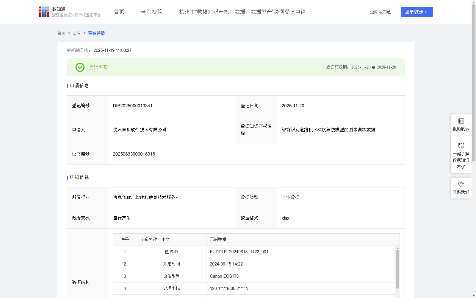
智能识别道路积水深度算法模型的图像训练数据
收藏浙江省数据知识产权登记平台2025-11-19 更新2025-11-26 收录
下载链接:
https://www.zjip.org.cn/home/announce/trends/8402071
下载链接
链接失效反馈官方服务:
资源简介:
本数据集主要用于提升AI模型对道路积水深度的识别能力与精确性。通过对该数据集的训练,使AI模型能够通过图像分析实现道路积水深度的识别,并可应用于城市内涝监测、高速公路积水预警等场景。同时,本数据集可为市政排水管理、交通应急响应及智慧城市建设中的积水风险评估提供决策支持,助力构建城市洪涝预警系统。
1.数据采集
通过企业自有摄像设备自行采集道路积水图像,记录图像ID、采集时间、设备型号、地理坐标、光照条件、天气状况参数等数据。
2.数据预处理与标注
通过数据清洗剔除模糊、重复图像。按6:2:2比例划分训练集/验证集/测试集,设置多级标注体系:
一级标签:积水/无积水
二级标签:浅积水<5cm/深积水≥5cm
辅助标注:边界框坐标
3.模型选择与初始化
采用ResNet-50+UNet混合架构,初始化参数并优化超参数:学习率0.001-0.0001动态调整,批量大小1-16动态调整,锚框参数适配积水区域形态。
4.模型训练
基于PyTorch实施分布式训练,采用混合精度训练(FP16)提升效率。设置训练时长,数据增强模拟复杂场景,添加动态模糊、遮挡物干扰等特效,模拟雨雾/夜间/油膜反光等复杂光学干扰。设置早停机制(patience=15)防止过拟合。
5.模型评估
在训练模型的过程中,使用验证集调整超参数,训练完成后在测试集上评估模型表现,评估指标包含:
基础性能:mAP@0.5、误报率
场景鲁棒性测试:夜间误报率
This dataset is primarily used to enhance the recognition capability and accuracy of AI models in identifying road waterlogging depth. Training AI models on this dataset enables them to recognize road waterlogging depth through image analysis, which can be applied in scenarios such as urban waterlogging monitoring and expressway waterlogging early warning. Meanwhile, this dataset can provide decision support for waterlogging risk assessment in municipal drainage management, traffic emergency response and smart city construction, helping to build urban flood early warning systems.
1. Data Collection
Road waterlogging images are collected using the enterprise's own camera equipment, with data such as image ID, collection time, equipment model, geographic coordinates, lighting conditions and weather status parameters recorded.
2. Data Preprocessing and Annotation
Blurry and duplicate images are removed via data cleaning. The dataset is split into training, validation and test sets at a ratio of 6:2:2, and a multi-level annotation system is established:
- Primary label: Waterlogging / No Waterlogging
- Secondary label: Shallow waterlogging (<5cm) / Deep waterlogging (≥5cm)
- Auxiliary annotation: Bounding box coordinates
3. Model Selection and Initialization
A hybrid ResNet-50 + UNet architecture is adopted, with parameters initialized and hyperparameters optimized: dynamically adjust the learning rate between 0.001 and 0.0001, dynamically adjust the batch size from 1 to 16, and adapt anchor box parameters to the morphology of waterlogging areas.
4. Model Training
Distributed training is implemented based on PyTorch, and mixed-precision training (FP16) is used to improve training efficiency. Training duration is set, and data augmentation is applied to simulate complex scenarios, adding effects such as dynamic blur and occlusion interference to replicate complex optical disturbances like rain/fog, nighttime conditions and oil film reflection. An early stopping mechanism (patience=15) is set to prevent overfitting.
5. Model Evaluation
During the model training process, the validation set is used to adjust hyperparameters. After training is completed, the model performance is evaluated on the test set. The evaluation metrics include:
- Basic performance: mAP@0.5, False Positive Rate
- Scenario robustness test: Nighttime False Positive Rate
提供机构:
杭州声贝软件技术有限公司
创建时间:
2025-08-03
搜集汇总
数据集介绍
背景与挑战
背景概述
该数据集是用于训练智能识别道路积水深度算法模型的图像数据,包含606条记录,每日更新,覆盖图像ID、采集参数、标签和模型性能指标等字段。它专为提升AI模型在道路积水深度识别中的精确性而设计,可应用于城市内涝监测和智慧城市建设,通过算法规则优化模型鲁棒性。
以上内容由遇见数据集搜集并总结生成


