Plankton and environmental monitoring dataset from the Iroise Marine Natural Park (NE Atlantic, 2010-2023)
收藏DataCite Commons2025-08-05 更新2025-04-16 收录
下载链接:
https://www.seanoe.org/data/00943/105465/
下载链接
链接失效反馈官方服务:
资源简介:
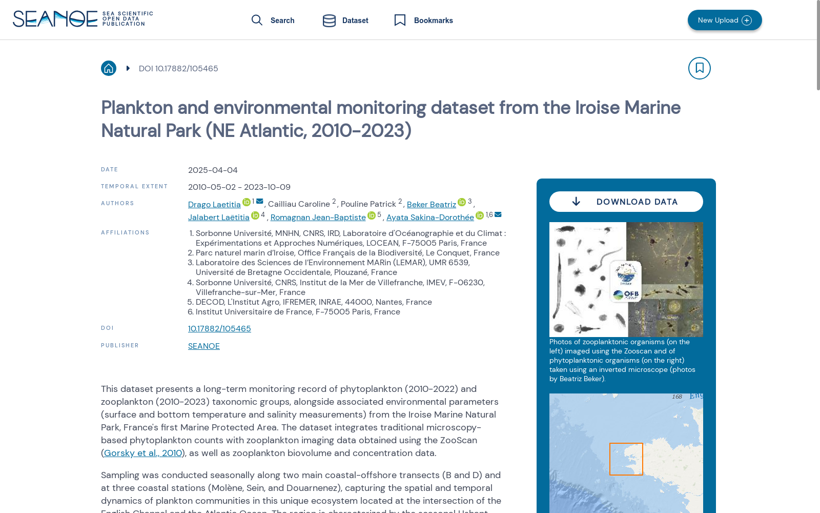
This dataset presents a long-term monitoring record of phytoplankton (2010-2022) and zooplankton (2010-2023) taxonomic groups, alongside associated environmental parameters (surface and bottom temperature and salinity measurements) from the Iroise Marine Natural Park, France's first Marine Protected Area. The dataset integrates traditional microscopy-based phytoplankton counts with zooplankton imaging data obtained using the ZooScan (Gorsky et al., 2010), as well as zooplankton biovolume and concentration data.
Sampling was conducted seasonally along two main coastal-offshore transects (B and D) and at three coastal stations (Molène, Sein, and Douarnenez), capturing the spatial and temporal dynamics of plankton communities in this unique ecosystem located at the intersection of the English Channel and the Atlantic Ocean. The region is characterized by the seasonal Ushant thermal front, which creates diverse habitats supporting rich plankton communities.
Phytoplankton identification was performed consistently by the same taxonomist throughout the study period, resulting in a high-resolution dataset with 573 distinct taxa across the 785 phytoplankton samples. Zooplankton samples (total number of samples = 650) were digitized using the ZooScan imaging system (Gorsky et al., 2010), with organisms automatically sorted using built-in semi automatic algorithms (random forest and convolutional neural networks) of the Ecotaxa platform (Picheral et al., 2017). Expert taxonomists then reviewed and validated the classifications resulting in 103 taxonomic and morphological groups. Individual zooplankton images are accessible through the EcoTaxa web platform for further morphometric analyses.
Bibliography
Gorsky, G., Ohman, M.D., Picheral, M., Gasparini, S., Stemmann, L., Romagnan, J.-B., Cawood, A., Pesant, S., Garcia-Comas, C., Prejger, F., 2010. Digital zooplankton image analysis using the ZooScan integrated system. J. Plankton Res. 32, 285–303. https://doi.org/10.1093/plankt/fbp124
Picheral, M., Colin, S., Irisson, J.-O., 2017. EcoTaxa, a tool for the taxonomic classification of images.
WoRMS Editorial Board, 2025. World Register of Marine Species https://doi.org/10.14284/170
Dataset content
The dataset contains three distinct tables all containing both text and numerical data.
The first dataset integrates zooplankton measurements with their corresponding environmental parameters and is organised as follows (see also units_PNMI_data_paper.csv):
- Metadata information (columns 1-8): Station name (column 1) Transect name (column 2) Coordinates: longitude and latitude (columns 3-4, in DD.dddd) Sampling time: date, year, month, and julian day (columns 5-8)
- Environmental measurements: Surface and bottom temperature (columns 9-10, in °C) Surface and bottom salinity (columns 11-12, in PSU)
- Biological data for each taxonomic group: Sample abundance in individuals/m³ (columns 13-116, prefix "conc_" + taxa name) Total biovolume in mm³/m³ (columns 117-220, prefix "tot_biov_" + taxa name) Mean individual biovolume in mm³ (columns 221-324, prefix "mean_biov_" + taxa name)
The second dataset contains phytoplankton data and follows a similar organizational structure:
- Metadata information (columns 1-8): Station name (column 1) Transect name (column 2) Coordinates: longitude and latitude (columns 3-4, in DD.dddd) Sampling time: date, year, month, and julian day (columns 5-8)
- Environmental measurements: Surface and bottom temperature (columns 9-10, in °C) Surface and bottom salinity (columns 11-12, in PSU)
- Phytoplankton taxa concentrations: Surface abundance in individuals/L (columns 13-580, prefix "surface_" + taxa name) Bottom abundance in individuals/L (columns 581-1148, prefix "bottom_" + taxa name)
Each taxa is provided in the third dataset with the corresponding unique identifier called aphiaID from the World Register of Marine Species (WoRMS Editorial Board, 2025), which enables unambiguous species identification across databases.
For the transect stations (D1 through D6 and B1 through B7), phytoplankton was initially sampled at sub-surface and bottom depths before 2017 (see Table 2). Following the introduction of CTD profiling in 2017, vertical profiles from 2017-2018 revealed that at offshore stations (B5-B7 and D5-D6), the chlorophyll a maximum, when present, consistently occurred between 15-18 m depth. At coastal stations (up to 40 m deep), strong vertical mixing typically maintained a homogeneous water column with no deep chlorophyll maximum, though when present, it also occurred at approximately 15 m depth. Based on these observations, bottom sampling was discontinued in 2019 and replaced with sampling at 15 m depth to better capture phytoplankton biomass.
本数据集呈现了法国首个海洋保护区——伊罗伊斯海洋自然公园(Iroise Marine Natural Park)内,2010-2022年浮游植物、2010-2023年浮游动物的分类学类群长期监测记录,以及配套的环境参数数据(表层与底层水温、盐度测定结果)。本数据集整合了基于传统显微镜计数的浮游植物统计数据、采用ZooScan成像系统(Gorsky等,2010)获取的浮游动物成像数据,以及浮游动物生物体积与浓度数据。
采样工作按季节在两条主要的近岸-离岸断面(B断面与D断面)以及三个近岸站位(莫莱讷岛、桑岛和杜阿尔讷内斯)开展,完整捕捉了这片位于英吉利海峡与大西洋交汇处的独特生态系统中浮游生物群落的时空动态。该区域以季节性乌尚特热锋为典型特征,该热锋造就了多样生境,支撑起丰富的浮游生物群落。
本研究周期内,浮游植物的分类鉴定均由同一位分类学家完成,最终得到覆盖785份浮游植物样本、包含573个独特类群的高分辨率数据集。共计650份浮游动物样本通过ZooScan成像系统(Gorsky等,2010)完成数字化,依托Ecotaxa平台(Picheral等,2017)内置的半自动算法(随机森林(random forest)与卷积神经网络(convolutional neural networks))实现生物的自动分类。随后由专业分类学家对分类结果进行复核与验证,最终得到103个分类学与形态学类群。单份浮游动物图像可通过Ecotaxa网页平台获取,用于后续的形态计量学分析。
参考文献
Gorsky, G., Ohman, M.D., Picheral, M., Gasparini, S., Stemmann, L., Romagnan, J.-B., Cawood, A., Pesant, S., Garcia-Comas, C., Prejger, F., 2010. 基于ZooScan集成系统的数字化浮游动物图像分析. J. Plankton Res. 32, 285–303. https://doi.org/10.1093/plankt/fbp124
Picheral, M., Colin, S., Irisson, J.-O., 2017. EcoTaxa:图像分类学分类工具
WoRMS编辑委员会(WoRMS Editorial Board), 2025. 世界海洋物种登记册(World Register of Marine Species)https://doi.org/10.14284/170
数据集内容
本数据集包含三张均包含文本与数值数据的独立数据表。
第一张数据表整合了浮游动物测量数据与对应的环境参数数据,结构如下(详见units_PNMI_data_paper.csv):
- 元数据信息(第1-8列):站位名称(第1列)、断面名称(第2列)、坐标:经度与纬度(第3-4列,单位为十进制度DD.dddd)、采样时间:日期、年份、月份与儒略日(第5-8列)
- 环境测量数据:表层与底层水温(第9-10列,单位为摄氏度°C)、表层与底层盐度(第11-12列,单位为实用盐度单位PSU)
- 各分类学类群的生物数据:单位体积个体丰度(单位为ind./m³,第13-116列,前缀为"conc_"+类群名称)、单位体积总生物体积(单位为mm³/m³,第117-220列,前缀为"tot_biov_"+类群名称)、单个个体平均生物体积(单位为mm³,第221-324列,前缀为"mean_biov_"+类群名称)
第二张数据表包含浮游植物数据,组织结构与前者类似:
- 元数据信息(第1-8列):站位名称(第1列)、断面名称(第2列)、坐标:经度与纬度(第3-4列,单位为十进制度DD.dddd)、采样时间:日期、年份、月份与儒略日(第5-8列)
- 环境测量数据:表层与底层水温(第9-10列,单位为摄氏度°C)、表层与底层盐度(第11-12列,单位为实用盐度单位PSU)
- 浮游植物类群丰度:表层水体个体丰度(单位为ind./L,第13-580列,前缀为"surface_"+类群名称)、底层水体个体丰度(单位为ind./L,第581-1148列,前缀为"bottom_"+类群名称)
第三张数据表为各分类类群对应的唯一标识符aphiaID,该标识符来自世界海洋物种登记册(World Register of Marine Species),可实现不同数据库间物种的精准鉴定(WoRMS编辑委员会,2025)。
提供机构:
SEANOE
创建时间:
2025-04-07
搜集汇总
数据集介绍
背景与挑战
背景概述
该数据集提供了2010年至2023年在法国Iroise海洋自然公园(东北大西洋)的长期浮游生物和环境监测记录,涵盖浮游植物和浮游动物的分类群数据以及温度、盐度等环境参数。数据集基于季节性采样,结合传统显微镜和ZooScan成像技术,具有高分辨率(浮游植物573个分类群,浮游动物103个分类群),并经过专家验证,适用于研究海洋保护区内浮游生物群落的时空动态。
以上内容由遇见数据集搜集并总结生成


