2015-2019全球海洋地质地球物理数据集
收藏地球大数据科学工程2024-04-26 收录
下载链接:
https://data.casearth.cn/sdo/detail/60e55fca819aec59a2af706e
下载链接
链接失效反馈官方服务:
资源简介:
一、自由空间重力异常数据
提交的数据共分两类:一类是从相关网站收集的数据,一类是利用科学号海测数据跟网上收集数据融合后的数据。
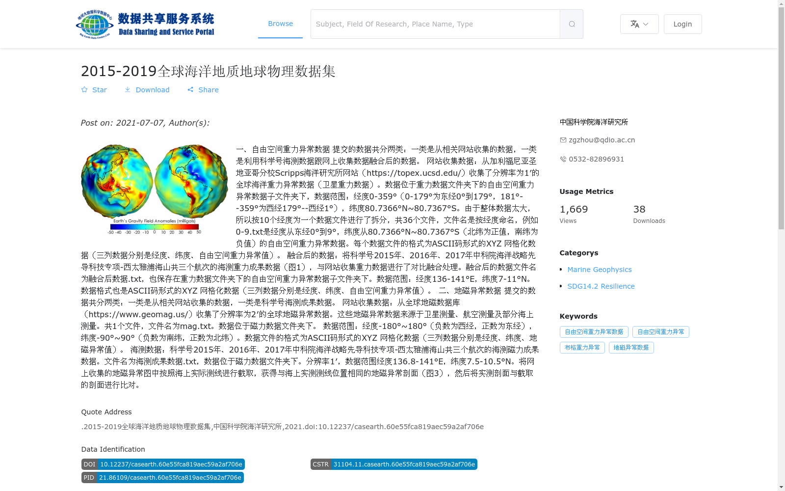
网站收集数据:从加利福尼亚圣地亚哥分校Scripps海洋研究所网站(https://topex.ucsd.edu/)收集了分辨率为1′的全球海洋重力异常数据(卫星重力数据)。数据位于重力数据文件夹下的自由空间重力异常数据子文件夹下,数据范围:经度0-359°(0-179°为东经0°到179°,181°--359°为西经179°--西经1°),纬度80.7366°N~80.7367°S。由于整体数据太大,所以按10个经度为一个数据文件进行了拆分,共36个文件,文件名是按经度命名,例如0-9.txt是经度从东经0°到9°,纬度从80.7366°N~80.7367°S(北纬为正值,南纬为负值)的自由空间重力异常数据。每个数据文件的格式为ASCII码形式的XYZ 网格化数据(三列数据分别是经度、纬度、自由空间重力异常值)。
融合后的数据:将科学号2015年、2016年、2017年中科院海洋战略先导科技专项-西太雅浦海山共三个航次的海测重力成果数据(图1),与网站收集重力数据进行了对比融合处理。融合后的数据文件名为融合后数据.txt,也保存在重力数据文件夹下的自由空间重力异常数据子文件夹下。数据范围:经度136-141°E,纬度7-11°N。数据格式也是ASCII码形式的XYZ 网格化数据(三列数据分别是经度、纬度、自由空间重力异常值)。
二、地磁异常数据
提交的数据共分两类:一类是从相关网站收集的数据,一类是科学号海测成果数据。
网站收集数据:从全球地磁数据库(https://www.geomag.us/)收集了分辨率为2′的全球地磁异常数据。这些地磁异常数据来源于卫星测量、航空测量及部分海上测量。共1个文件,文件名为mag.txt。数据位于磁力数据文件夹下。
数据范围:经度-180°~180°(负数为西经,正数为东经),纬度-90°~90°(负数为南纬,正数为北纬)。数据文件的格式为ASCII码形式的XYZ 网格化数据(三列数据分别是经度、纬度、地磁异常值)。
海测数据:科学号2015年、2016年、2017年中科院海洋战略先导科技专项-西太雅浦海山共三个航次的海测磁力成果数据。文件名为海测成果数据.txt,数据位于磁力数据文件夹下。分辨率1′,数据范围经度136.8-141°E,纬度7.5-10.5°N。将网上收集的地磁异常图中按照海上实际测线进行截取,获得与海上实测测线位置相同的地磁异常剖面(图3),然后将实测剖面与截取的剖面进行比对。
1. Free-air Gravity Anomaly Data
The submitted data consists of two categories: data collected from relevant websites, and data fused from in-situ marine survey data of the R/V Science and the online-collected data.
1.1 Online-collected Data
The global marine gravity anomaly data (satellite gravity data) with a resolution of 1 arcminute was downloaded from the website of the Scripps Institution of Oceanography, University of California, San Diego (https://topex.ucsd.edu/). This data is stored in the Free-air Gravity Anomaly Data subfolder under the Gravity Data folder. Its data range is: longitude 0° to 359° (0° to 179° correspond to 0°E to 179°E, while 181° to 359° correspond to 179°W to 1°W), latitude 80.7366°N to 80.7367°S. Owing to the large overall size of the dataset, the data is split into 36 files, with each file covering a 10-degree longitude span. The filenames are named after their longitude ranges, e.g., 0-9.txt contains free-air gravity anomaly data corresponding to longitude 0°E to 9°E and latitude 80.7366°N to 80.7367°S (positive values denote north latitude, negative values denote south latitude). Each data file is formatted as ASCII-encoded XYZ gridded data, with three columns representing longitude, latitude, and free-air gravity anomaly value, respectively.
1.2 Fused Data
The fused data was obtained through comparative fusion processing between the in-situ marine gravity survey data (Figure 1) from three cruises conducted in 2015, 2016 and 2017 under the Chinese Academy of Sciences (CAS) Strategic Priority Research Program on Oceanology – Western Pacific Yap Seamounts, and the online-collected gravity data. The fused data file is named "Fused Data.txt", and is also stored in the Free-air Gravity Anomaly Data subfolder under the Gravity Data folder. Its data range is: longitude 136°E to 141°E, latitude 7°N to 11°N. The data format is also ASCII-encoded XYZ gridded data, with three columns representing longitude, latitude, and free-air gravity anomaly value, respectively.
2. Geomagnetic Anomaly Data
The submitted geomagnetic anomaly data consists of two categories: data collected from relevant websites, and in-situ marine survey data from the R/V Science.
2.1 Online-collected Data
The global geomagnetic anomaly data with a resolution of 2 arcminutes was downloaded from the Global Geomagnetic Database (https://www.geomag.us/). This dataset is sourced from satellite surveys, aerial surveys and partial marine surveys, and is stored as a single file named "mag.txt" under the Magnetic Data folder. Its data range is: longitude -180° to 180° (negative values denote west longitude, positive values denote east longitude), latitude -90° to 90° (negative values denote south latitude, positive values denote north latitude). The data file is formatted as ASCII-encoded XYZ gridded data, with three columns representing longitude, latitude, and geomagnetic anomaly value, respectively.
2.2 In-situ Marine Survey Data
The in-situ marine magnetic survey data comes from three cruises conducted in 2015, 2016 and 2017 under the CAS Strategic Priority Research Program on Oceanology – Western Pacific Yap Seamounts, aboard the R/V Science. The data is stored as a file named "In-situ Survey Data.txt" under the Magnetic Data folder, with a resolution of 1 arcminute. Its data range is: longitude 136.8°E to 141°E, latitude 7.5°N to 10.5°N. To perform comparative analysis, geomagnetic anomaly profiles matching the positions of the in-situ marine survey lines were extracted from the online-collected geomagnetic anomaly map (Figure 3), and then the in-situ measured profiles were compared with the extracted profiles.
提供机构:
中国科学院海洋研究所
搜集汇总
数据集介绍
背景与挑战
背景概述
该数据集是2015-2019年全球海洋地质地球物理数据,主要包含自由空间重力异常和地磁异常两类数据,来源于网站收集和科学号海测融合成果。数据覆盖全球及西太平洋雅浦海山区域,格式为ASCII码XYZ网格化文本文件,总容量3.37 GB,适用于海洋地球物理研究。
以上内容由遇见数据集搜集并总结生成


