亚洲高山区冰川物质平衡和融水径流模拟与预估数据集(2000-2100)v2.0
收藏国家青藏高原科学数据中心2025-06-16 更新2025-08-23 收录
下载链接:
https://data.tpdc.ac.cn/zh-hans/data/ce45ee9a-2bd5-4ac9-9924-1b13a20e035d
下载链接
链接失效反馈官方服务:
资源简介:
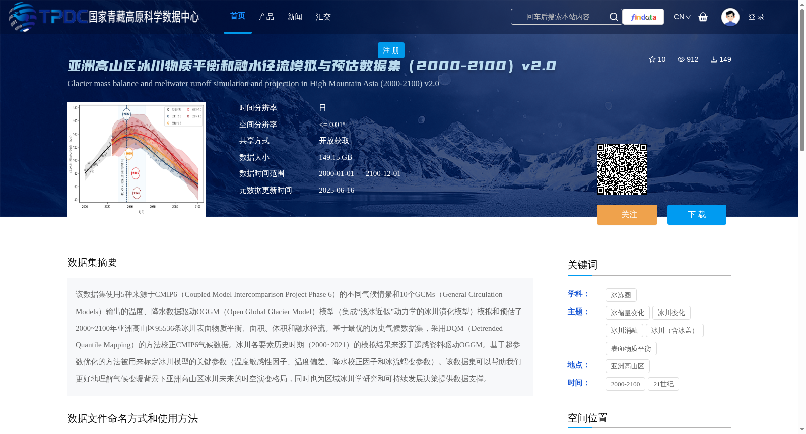
该数据集使用5种来源于CMIP6(Coupled Model Intercomparison Project Phase 6)的不同气候情景和10个GCMs(General Circulation Models)输出的温度、降水数据驱动OGGM(Open Global Glacier Model)模型(集成“浅冰近似”动力学的冰川演化模型)模拟和预估了2000~2100年亚洲高山区95536条冰川表面物质平衡、面积、体积和融水径流。基于最优的历史气候数据集,采用DQM(Detrended Quantile Mapping)的方法校正CMIP6气候数据。冰川各要素历史时期(2000~2021)的模拟结果来源于遥感资料驱动OGGM。基于超参数优化的方法被用来标定冰川模型的关键参数(温度敏感性因子、温度偏差、降水校正因子和冰流蠕变参数)。该数据集可以帮助我们更好地理解气候变暖背景下亚洲高山区冰川未来的时空演变格局,同时也为区域冰川学研究和可持续发展决策提供数据支撑。
This dataset uses 5 distinct climate scenarios from CMIP6 (Coupled Model Intercomparison Project Phase 6) and temperature and precipitation outputs from 10 GCMs (General Circulation Models) to drive the OGGM (Open Global Glacier Model) — a glacial evolution model integrating shallow ice approximation dynamics — to simulate and project the surface mass balance, area, volume and meltwater runoff of 95,536 glaciers across the high mountainous regions of Asia between 2000 and 2100. CMIP6 climate data were corrected via the DQM (Detrended Quantile Mapping) method using the optimal historical climate dataset. The historical simulation results of all glacial variables from 2000 to 2021 were derived from OGGM forced by remote sensing data. A hyperparameter optimization approach was adopted to calibrate the key parameters of the glacial model, namely the temperature sensitivity factor, temperature bias, precipitation correction factor and ice flow creep parameter. This dataset enables a deeper understanding of the future spatiotemporal evolution patterns of glaciers in the high mountainous regions of Asia amid climate warming, while providing robust data support for regional glaciological research and sustainable development decision-making.
提供机构:
赵宏宇,苏勃,张通,效存德
创建时间:
2025-04-28
搜集汇总
数据集介绍
背景与挑战
背景概述
该数据集模拟和预估了2000~2100年亚洲高山区95536条冰川的表面物质平衡、面积、体积和融水径流,使用5种CMIP6气候情景和10个GCMs数据驱动OGGM模型。数据以netCDF格式存储,空间分辨率<=0.01º,时间分辨率为日,适用于冰川学研究和区域可持续发展决策。
以上内容由遇见数据集搜集并总结生成


