墨脱风廓线雷达数据(2021-2022)
收藏国家青藏高原科学数据中心2025-03-21 更新2025-04-19 收录
下载链接:
https://data.tpdc.ac.cn/zh-hans/data/b64246d5-e5d2-4d0e-9802-10b2518bfa4a
下载链接
链接失效反馈官方服务:
资源简介:
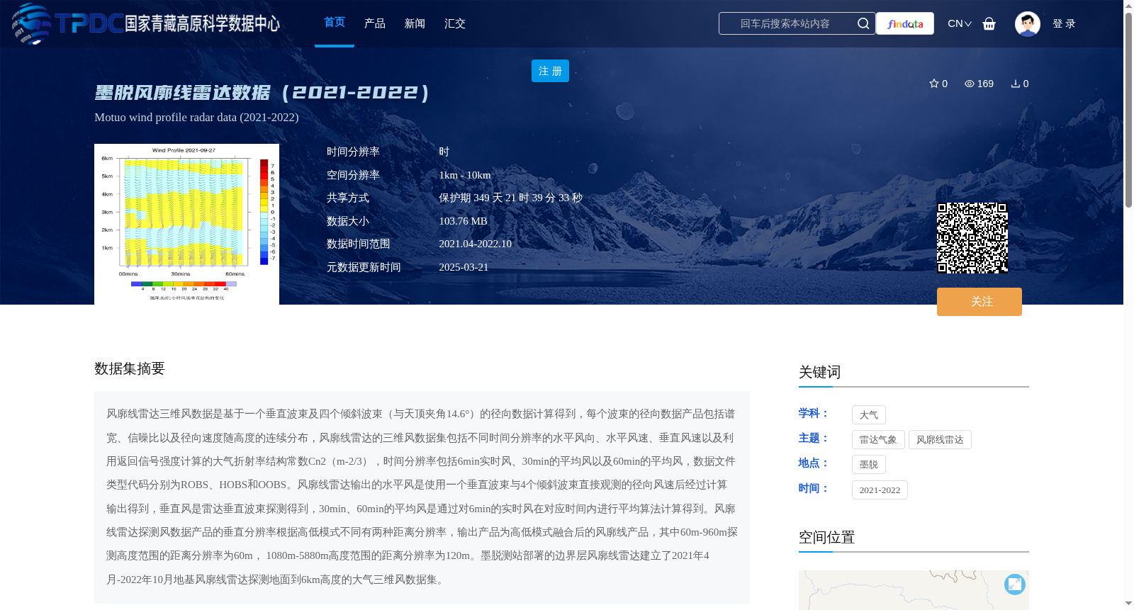
风廓线雷达三维风数据是基于一个垂直波束及四个倾斜波束(与天顶夹角14.6°)的径向数据计算得到,每个波束的径向数据产品包括谱宽、信噪比以及径向速度随高度的连续分布,风廓线雷达的三维风数据集包括不同时间分辨率的水平风向、水平风速、垂直风速以及利用返回信号强度计算的大气折射率结构常数Cn2(m-2/3),时间分辨率包括6min实时风、30min的平均风以及60min的平均风,数据文件类型代码分别为ROBS、HOBS和OOBS。风廓线雷达输出的水平风是使用一个垂直波束与4个倾斜波束直接观测的径向风速后经过计算输出得到,垂直风是雷达垂直波束探测得到,30min、60min的平均风是通过对6min的实时风在对应时间内进行平均算法计算得到。风廓线雷达探测风数据产品的垂直分辨率根据高低模式不同有两种距离分辨率,输出产品为高低模式融合后的风廓线产品,其中60m-960m探测高度范围的距离分辨率为60m, 1080m-5880m高度范围的距离分辨率为120m。墨脱测站部署的边界层风廓线雷达建立了2021年4月-2022年10月地基风廓线雷达探测地面到6km高度的大气三维风数据集。
The 3D wind dataset generated by wind profile radars is calculated using radial data collected by one vertical beam and four tilted beams (with a 14.6° angle from the zenith). The radial data product for each individual beam encompasses spectral width, signal-to-noise ratio (SNR), and the continuous altitude-resolved distribution of radial velocity. The 3D wind dataset from the wind profile radar includes horizontal wind direction, horizontal wind speed, vertical wind speed across multiple temporal resolutions, as well as the atmospheric refractive index structure constant Cn² (m^(-2/3)) derived from the returned signal intensity. The available temporal resolutions are 6-minute real-time wind, 30-minute averaged wind, and 60-minute averaged wind, with corresponding data file type codes being ROBS, HOBS, and OOBS respectively. The horizontal wind product output by the wind profile radar is derived via computational processing of radial wind speeds directly measured by one vertical beam and four tilted beams, whereas the vertical wind is detected solely by the radar's vertical beam. The 30-minute and 60-minute averaged wind products are calculated by applying temporal averaging algorithms to the 6-minute real-time wind data over their respective time windows. The wind data products from the wind profile radar have two range resolution modes based on high and low altitude operating configurations, and the final output products are fused wind profile products combining data from both modes. For the altitude range of 60 m to 960 m, the range resolution is 60 m, while for the range from 1080 m to 5880 m, the resolution is 120 m. The boundary layer wind profile radar deployed at the Motuo Station established a ground-based 3D atmospheric wind dataset spanning from the ground surface up to 6 km in altitude, with observations conducted between April 2021 and October 2022.
提供机构:
王改利
创建时间:
2025-02-28
搜集汇总
数据集介绍
背景与挑战
背景概述
该数据集包含2021年4月至2022年10月期间墨脱地区的地基风廓线雷达探测数据,覆盖地面到6km高度的大气三维风信息,包括水平风向、水平风速、垂直风速和大气折射率结构常数。数据具有不同时间分辨率(6分钟实时风、30分钟和60分钟平均风)和垂直分辨率(60m和120m),适用于大气科学研究。
以上内容由遇见数据集搜集并总结生成


