全球3小时河道洪水再分析数据GRFR V1.0(1980-2019)
收藏国家青藏高原科学数据中心2022-11-14 更新2024-03-01 收录
下载链接:
https://data.tpdc.ac.cn/zh-hans/data/89c36e43-3690-4e5b-bf0a-19d057876dfe
下载链接
链接失效反馈官方服务:
资源简介:
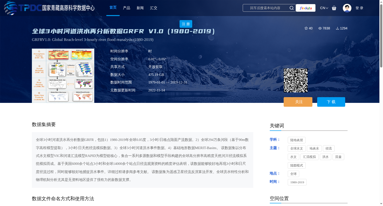
全球3小时河道洪水再分析数据GRFR,包括1)1980-2019年全球0.05度,3小时/日格点陆面产流数据。2)全球294万条河段(基于90m数字高程模型提取),3小时/日天然径流模拟数据。3)全球3小时河道洪水事件数据。4)基础地形数据MERIT-Basins。
该数据集以分布式水文模型VIC和河道汇流模型RAPID为模型链核心,集合一系列多源数据和模型手段构建的全球高分辨率高精度天然河川径流模拟系统模拟而成。基于美国6000余个站点3小时和全球14000余个站点日径流观测资料的精度评估表明,该数据能够较好地再现3小时和日尺度径流过程,同时能够较好地捕捉洪水事件。详细过程请参阅参考文献。
该数据集为遥感卫星径流反演算法开发、全球洪水特性分析和物理机制分析尤其是无资料地区提供了强有力的新数据支撑。
Global 3-hour river flood reanalysis dataset GRFR includes:
1) Global 0.05° grid-scale land surface runoff generation data at 3-hourly/daily intervals from 1980 to 2019.
2) Global 2.94 million river segments (extracted from 90m digital elevation model) with natural runoff simulation data at 3-hourly/daily intervals.
3) Global 3-hourly river flood event data.
4) Basic topographic dataset MERIT-Basins.
This dataset was developed based on a global high-resolution and high-precision natural river runoff simulation system, which takes the distributed hydrological model VIC and river routing model RAPID as the core of the model chain, and integrates a series of multi-source data and modeling methods.
Accuracy assessments based on 3-hourly runoff observation data from over 6,000 stations in the United States and daily runoff observation data from more than 14,000 global stations demonstrate that this dataset can well reproduce 3-hourly and daily-scale runoff processes, and effectively capture flood events. For detailed procedures, please refer to the references.
This dataset provides powerful new data support for the development of remote sensing satellite runoff inversion algorithms, global flood characteristic analysis and physical mechanism analysis, especially in data-scarce regions.
提供机构:
杨媛,潘铭,林佩蓉
创建时间:
2022-11-03
搜集汇总
数据集介绍
背景与挑战
背景概述
全球3小时河道洪水再分析数据GRFR V1.0(1980-2019)是一个高分辨率、高精度的全球河川径流模拟数据集,包含陆面产流、天然径流、河道洪水事件和基础地形数据,适用于洪水特性分析和无资料地区研究。
以上内容由遇见数据集搜集并总结生成


