A dataset of annual surface water extent in the Xijiang River Basin from 1986 to 2023
收藏DataCite Commons2025-09-17 更新2025-04-16 收录
下载链接:
https://www.scidb.cn/detail?dataSetId=66f8a6df0edc40b99241cbe6eb5226cf
下载链接
链接失效反馈官方服务:
资源简介:
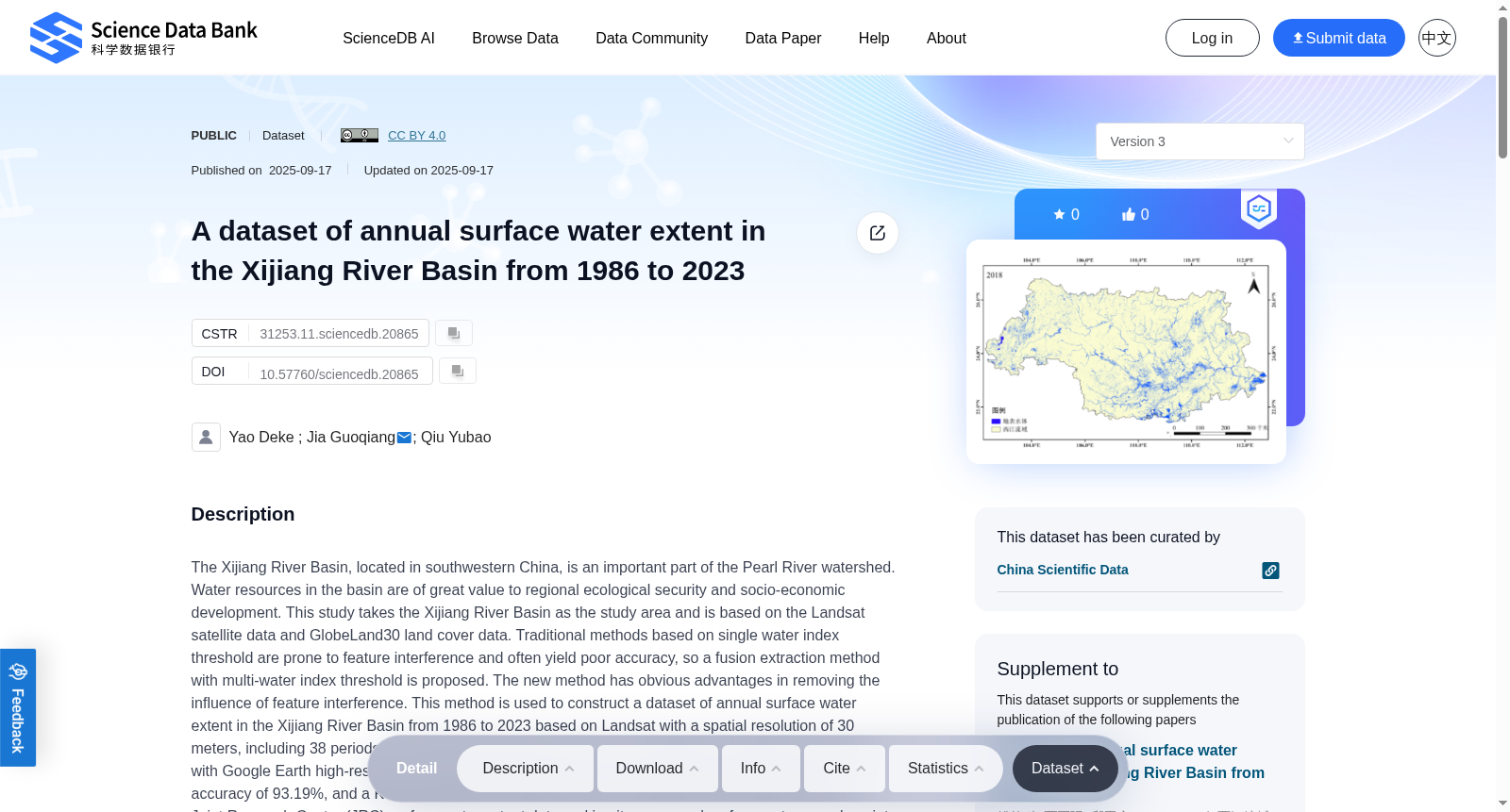
The Xijiang River Basin, located in southwestern China, is an important part of the Pearl River watershed. Water resources in the basin are of great value to regional ecological security and socio-economic development. This study takes the Xijiang River Basin as the study area and is based on the Landsat satellite data and GlobeLand30 land cover data. Traditional methods based on single water index threshold are prone to feature interference and often yield poor accuracy, so a fusion extraction method with multi-water index threshold is proposed. The new method has obvious advantages in removing the influence of feature interference. This method is used to construct a dataset of annual surface water extent in the Xijiang River Basin from 1986 to 2023 based on Landsat with a spatial resolution of 30 meters, including 38 periods of surface water extent vector data. The dataset is compared and verified with Google Earth high-resolution images sample points by random sampling, indicating an overall accuracy of 93.19%, and a Kappa coefficient of 0.8639. Further comparison with the European Union Joint Research Center (JRC) surface water extent data and in-situ measured surface water sample points showed that the overall accuracy relative to the JRC annual data exceeded 92%, with the Kappa coefficients above 0.84. All measured points are all within the 30-meter buffer range of the extracted surface water boundaries, demonstrating strong consistency. This dataset provides long-term time series data for water resource management and ecological protection in the Xijiang River Basin, and offers a scientific basis for assessing the impacts of climate change on basin ecology and supporting the sustainable use of regional water resources.
地处中国西南地区的西江流域,是珠江流域的重要组成部分。流域内的水资源对于区域生态安全与社会经济发展具有重要价值。本研究以西江流域为研究区域,以Landsat卫星数据与GlobeLand30土地覆盖数据为基础。传统的单一水体指数阈值法极易受到地物干扰,往往精度欠佳,为此本研究提出了一种多水体指数阈值融合提取方法。该新方法在消除地物干扰影响方面具有显著优势。基于空间分辨率为30米的Landsat数据,本研究利用该方法构建了1986年至2023年西江流域年度地表水体范围数据集,包含38期地表水体范围矢量数据。通过随机采样选取谷歌地球(Google Earth)高分辨率影像样点对该数据集进行验证比对,结果显示其总体精度达93.19%,Kappa系数为0.8639。进一步结合欧盟联合研究中心(European Union Joint Research Center,JRC)地表水体范围数据与原位实测地表水体样点开展比对,结果表明该数据集相较于JRC年度地表水体数据的总体精度超过92%,Kappa系数均高于0.84。所有实测样点均落在提取得到的地表水体边界30米缓冲范围内,证明二者具有极强的一致性。本数据集为西江流域水资源管理与生态保护提供了长时序数据支撑,同时为评估气候变化对流域生态的影响、支撑区域水资源可持续利用提供了科学依据。
提供机构:
Science Data Bank
创建时间:
2025-02-18
搜集汇总
数据集介绍
背景与挑战
背景概述
该数据集提供了1986年至2023年西江流域地表水体范围的年度矢量数据,空间分辨率为30米,共包含38期数据。通过多水指数阈值融合提取方法,有效减少了特征干扰,验证结果显示总体精度超过92%,Kappa系数高于0.84,为流域水资源管理和生态保护提供了长期时间序列数据支持。
以上内容由遇见数据集搜集并总结生成


