祁连山区域30m土地覆盖分类产品数据集(1985-2017)V1.0
收藏地球大数据科学工程2024-03-04 收录
下载链接:
https://data.casearth.cn/sdo/detail/5feae827819aec33049b7cd6
下载链接
链接失效反馈官方服务:
资源简介:
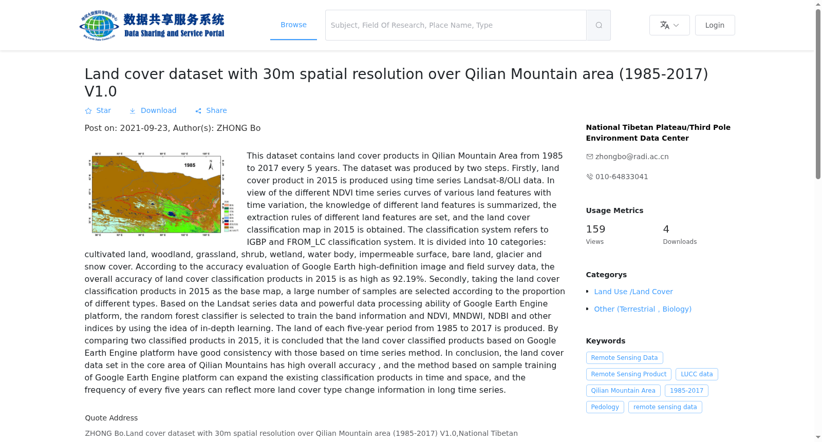
本数据集包括祁连山区域1990年至2017年每5年一期的30m土地覆盖分类产品。该产品首先利用Landsat-8/OLI构造2015年时间序列数据,针对各类地物随时间变化呈现的NDVI时间序列曲线不同,对不同地物特征进行知识归纳,设定提取规则不同地物信息,得到2015年的土地覆盖分类图。分类系统参考了IGBP分类系统和FROM_LC分类系统,共分为耕地、林地、草地、灌丛、湿地、水体、不透水面、裸地、冰川和积雪共10大类。由Google Earth高清影像和实地调研数据进行精度评价,得出2015年土地覆盖分类产品的总体精度高达92.19%。以2015年的土地覆盖分类产品为底图,按各类别的比例选取大量样本,基于Google Earth Engine平台的Landsat系列数据和强大地数据处理能力,利用深度学习的思想,选取随机森林分类器,对波段信息和NDVI、MNDWI、NDBI等指数进行样本训练,生产出1985-2017年每5年一期的土地覆盖分类产品。对2套2015年的分类产品进行比较,得出基于Google Earth Engine平台生产的土地覆盖分类产品与基于时间序列方法得到的分类产品具有很好的一致性。总之,祁连山核心区的土地覆盖数据集具有较高的总体精度,且基于Google Earth Engine平台样本训练的方法能够在时间和空间上对现有的分类产品进行扩展,每5年一期的频次能够在长时间序列上反映更多的土地覆盖类型变化信息。
This dataset contains 30m land cover classification products for the Qilian Mountains region, with a 5-year interval from 1990 to 2017. Initially, 2015 time-series data was constructed using Landsat-8/OLI. Based on the distinct NDVI time-series curves exhibited by different land cover types during temporal changes, knowledge induction was conducted for the characteristics of various land features, and specific extraction rules were set for different land objects to obtain the 2015 land cover classification map. The classification system refers to the IGBP classification system and the FROM_LC classification system, which is divided into 10 major categories in total: cropland, forestland, grassland, shrubland, wetland, water body, impervious surface, bare land, glacier and snow cover. The accuracy of the 2015 land cover classification product was evaluated using high-resolution Google Earth imagery and field survey data, resulting in an overall accuracy of up to 92.19%. Taking the 2015 land cover classification product as the base map, a large number of samples were selected according to the proportion of each category. Relying on Landsat series data and the powerful data processing capabilities of the Google Earth Engine platform, adopting the idea of deep learning and selecting the random forest classifier, the model was trained with band information and indices such as NDVI, MNDWI, and NDBI, thereby producing land cover classification products with a 5-year interval from 1985 to 2017. By comparing the two sets of 2015 classification products, it was found that the land cover classification product generated on the Google Earth Engine platform has excellent consistency with the one obtained via the time-series method. In summary, the land cover dataset for the core area of the Qilian Mountains has a high overall accuracy. The sample training method based on the Google Earth Engine platform can extend existing classification products both temporally and spatially, and the 5-year interval frequency can reflect more change information of land cover types over a long time series.
提供机构:
国家青藏高原科学数据中心
搜集汇总
数据集介绍
背景与挑战
背景概述
该数据集包含祁连山区域1985-2017年每5年的30米分辨率土地覆盖分类产品,采用两步法生成,分类系统包含10个类别,2015年产品精度达92.19%。数据基于Google Earth Engine平台扩展,适用于长时间序列土地覆盖变化研究。
以上内容由遇见数据集搜集并总结生成


