淮河-王家坝附近水域水体变化监测图(2020年)
收藏国家地球系统科学数据中心2020-07-29 更新2024-03-04 收录
下载链接:
https://www.geodata.cn/data/datadetails.html?dataguid=173119819559714&docId=12355
下载链接
链接失效反馈官方服务:
资源简介:
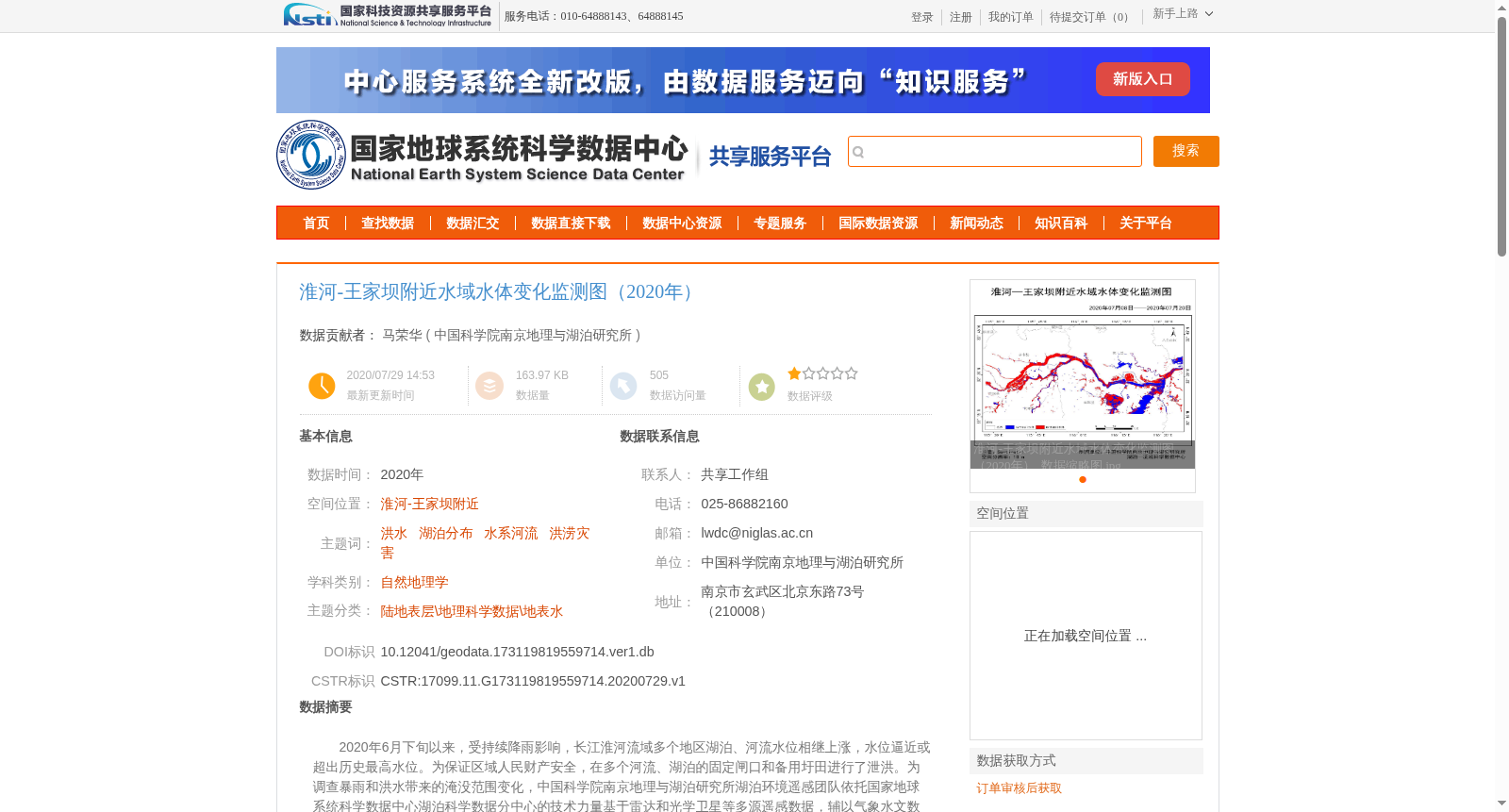
2020年6月下旬以来,受持续降雨影响,长江淮河流域多个地区湖泊、河流水位相继上涨,水位逼近或超出历史最高水位。为保证区域人民财产安全,在多个河流、湖泊的固定闸口和备用圩田进行了泄洪。为调查暴雨和洪水带来的淹没范围变化,中国科学院南京地理与湖泊研究所湖泊环境遥感团队依托国家地球系统科学数据中心湖泊科学数据分中心的技术力量基于雷达和光学卫星等多源遥感数据,辅以气象水文数据为参考提取了典型洪泛区洪水前后的淹没范围,计算淹没区面积及其变化,以期分析洪水带来的生态和经济影响。该数据集在淮河王家坝(阜阳)-淮南段洪泛区开展监测研究。以Sentinel-1的雷达卫星数据为主实现了研究区域内洪水事件发生前后至少1次的水体面积监测。
该数据集数据格式为jpg图片数据,每期数据出一张图。
Since late June 2020, driven by persistent rainfall, water levels of lakes and rivers in various regions across the Yangtze River and Huaihe River basins rose sequentially, approaching or exceeding the historical maximum water levels. To safeguard the lives and property of local residents, flood discharge operations were carried out at fixed sluices and emergency polders along multiple rivers and lakes. To investigate the changes in inundation extent caused by the rainstorm and subsequent flood, the Lake Environmental Remote Sensing Team from the Nanjing Institute of Geography and Limnology, Chinese Academy of Sciences, leveraged technical support from the Lake Science Data Sub-center of the National Earth System Science Data Center. The team extracted inundation extents of typical floodplains before and after the flood event using multi-source remote sensing data including radar and optical satellites, supplemented by meteorological and hydrological data as references. They further calculated the area of inundated regions and their variation trends, with the goal of analyzing the ecological and economic impacts of the flood. This dataset was developed for monitoring and research in the floodplain section of the Huaihe River from Wangjiaba (Fuyang) to Huainan. Sentinel-1 radar satellite data was primarily utilized to conduct water body area monitoring for the study area at least once before and once after the occurrence of the flood event. The dataset is provided in JPG image format, with one image generated for each data period.
提供机构:
中国科学院南京地理与湖泊研究所
创建时间:
2020-07-29
搜集汇总
数据集介绍
背景与挑战
背景概述
淮河-王家坝附近水域水体变化监测图(2020年)数据集通过多源遥感数据监测了洪水前后的水体面积变化,适用于洪水灾害和生态影响研究。数据以jpg图片格式提供,由中国科学院南京地理与湖泊研究所制作,具有较高的科研价值。
以上内容由遇见数据集搜集并总结生成


